|
RÍO MARAÑÓN: Grand Canyon of the Amazon (Upper) |
|
207 km (116 miles), class IV+ ; 9-11 days |
| launches: Sep6 Oct2 Oct30 (2025) RESERVE |
| OTHER TRIPS |
| versión ESPAÑOL |
The Upper Amazon River (Río Marañon) in the Andes offers the finest raft-support trip in South America. On this trip we will paddle through the Upper and Inner Gorge Grand Canyon sections, with challenging class IV rapids, soothing hot springs, amazing side hikes, and beautiful beach camps. You will have the option of continuing down the Central+LowerGC sections after this trip. Help us stop the dams! SAVE RÍO MARAÑON!
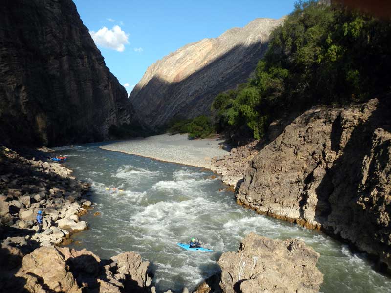
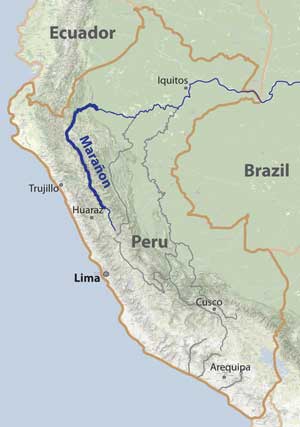
Río Marañon is the parent stream or "mainstem" source of the Amazon, meeting no stronger rival at any junction on its route to the Atlantic. It therefore is the Upper Amazon and the only stream meriting this title. From its birthplaces at glaciers on the highest tropical mountains in the world [Yerupajá and Huascarán; 6600-6800 m (21000-22000 ft)], the Marañon courses north over about 1/3 of the length of the country of Peru in the central Andes. As it does so, it is squeezed into the bottom of an arid canyon up to 3000 m (10000 ft) deep on both sides - more than double the depth of Arizona's Grand Canyon. A SierraRios expedition in 2012 explored what the Marañón was like, and learned of plans for over a dozen hydroelectric dams. These expeditions are intended to increase appreciation of the river so more authoritative opinions can be formed against the dams and action taken. Voice your opinion now in the SAVE RIO MARANON campaign. Sign a petition! Watch a film. Make the issue known. Support the cause with a donation! The trips are open to everyone: rafters, kayakers, IKers, and passengers. No prior whitewater experience is necessary on a raft. SierraRios now offers full service trips comparable to standard Grand Canyon outfitters.
This 12-day trip covers the first two of four Grand Canyon sections:
Upper: 127 km; class IV; ~7 days; Puchka-to-Huchus
InnerGorge: 81 km; class IV(V); ~5 days; Huchus-to-Chagual
Central:149 km; class II-III (IV); ~7 days; Chagual-to-Balsas
Lower: 143 km; class III-IV; ~7 days; Balsas-to-P.Malleta
- the expedition will usually continue through the Central+LowerGC sections for 12-14 additional days
- Some expeditions will continue into the Jungle Pongos section.
- lt is possible to join or leave any expedition at any access point.
- Private groups are welcome to schedule a trip - either as a fully guided trip or a self-organized trip. Do it soon and help us save the river!
EMAIL LIST: Sign up for our email list and you'll be be advised of upcoming trips and often special lower rates compared to the general contribution rate.
| MORE INFO: |
| 2012 trip (First Descent Amazon) |
| OUTFITTING SERVICE |
| SPOT (latest GPS position) |
| PAYMENTS |
| -------------------------------------------- |
| Trip reports: Sep28(2013) |
| Jan16(2014) :: Jun4(2014) |
| Oct14 info :: Oct30 info |
MARAÑON SECTIONS:
The "Grand Canyon Amazon" refers to the profound canyon section of Río Marañon located downsteam of the Río Puchka confluence and upstream of the Jungle Pongos section. This canyon is generally 2600-3000 m (8000-10000 ft) deep on both sides throughout its length. Access points conveniently divide it into four sections, each with various difficulties and other features. These are summarized in the table below to help you decide the best trip for you. In general, the river is class III-IV in difficulty and comparable to the Grand Canyon of the Colorado (GCC), though some rapids of the Upper Grand Canyon Amazon section are considerably more challenging.
Anyone (even folks with no river experience) can always join a normal SierraRios trip through any section scheduled and have experienced class V guides lead the trip. Ideally, participants in charge of a raft or kayak should feel challenged, but not scared. If you're planning to row or kayak, you should note the difficulties below. It is always possible to avoid the tough Inner Gorge section by joining an expedition at Chagual (which can be arranged even for expeditions launching on the Upper) or taking a shuttle around it. It's best to discuss this possibility with the trip planner, as we can usually accommodate some class III boaters even on the Upper section.
| section | km | days | class | rapids | scenery | hikes | cultural | note | |
| Headwaters | 200 | ~10 | V/P | +++++ | +++++ | ++++ | ++ | not raftable; many long portages | |
| Upper GC | 127 | ~7 | IV | +++++ | +++++ | ++++ | ++ | one of the best week-long trips in Peru | |
| Inner Gorge GC | 81 | ~5 | IV (V) | +++++ | +++++ | +++ | + | very difficult; lining/portage at Wasson's | |
| Central GC | 149 | ~7 | II-III (IV) | +++ | +++++ | +++++ | +++ | incredible canyon scenery | |
| Lower GC | 143 | ~7 | III-IV | ++++ | +++ | +++ | ++++ | soon to be dammed: Veracruz & ChadinII | |
| Cumba Valley | 81 | ~2 | I-II | + | ++ | + | ++ | flat and sometimes windy | |
| Jungle Pongos1 | 85 | ~3 | III+ | +++ | +++ | ++ | +++++ | lush jungle; often rainy; need Awajún permission | |
| Jungle Pongos2 | 215 | ~6 | I-II (III) | + | +++ | + | ++++ | mostly mellow big rio; need Awajún permission | |
| -------------------------- | -- | --- | --- | --- | --- | --- | --- | -------------------------- | |
| TOTAL RAFTABLE | 881 | 36 | - | - | - | - | - | awesome long Upper Amazon trip |
====================================================================================
Upper Grand Canyon Amazon (Puchka section)
class IV
127 km (79 miles) ; ~7 days
Puchka (2080 m) to Huchus (1600 m) [6900 ft to 5280 ft];
4.0 m/km (22 ft/mile)
Google Maps (put-in area)
The Upper Grand Canyon Amazon section is filled with class III and IV rapids and most folks usually consider it a little more challenging than the Grand Canyon Colorado. The UpperGC section is quite scenic in arid canyon and has numerous interesting side excursions - to narrows, waterfalls, and ruins. There are some residents to encounter but not many, so cultural interactions are usually minimal. The three toughest rapids are Pauca (IV), Sanachgán (IV), and Shapalmonte (IV). While they can be somewhat technical at low flows, at high flows these rapids have high raft flip potential (rating of 10 on GC scale) and while not more dangerous than Lava Falls, one is difficult to portage (Shapalmonte). Some rapids are very long, including Huaycanoragra, Yesojirca Narrows runout, and Sanachgán. This section has an easy access point at Puente Jitaraxan/Comara (km 100) at the road bridge joining the towns of Sihuas and Tayabamba, and can also be accessed at Huchus (km 127). At least two dams are planned for this section including the Yaku project that has been under study intensively in 2015. See slideshows of this section at low and high water:
PUCHKA SECTION SLIDESHOW Jan16 [from the Jan16 (2014) trip]
PUCHKA SECTION SLIDESHOW_Sep28 [from the Sep28 (2013) trip]
====================================================================================
Inner Gorge Grand Canyon Amazon
class IV (V)
81 km (49 miles) ; ~5 days
Huchus (1600 m) to Chagual (1260 m) [5280 ft to 4160 ft];
4.2 m/km (23 ft/mile)
Google Maps (put-in area)
The Inner Gorge section is 81 km from Huchus to Chagual and significantly more difficult than the Grand Canyon Colorado. The section starts with ~20 km of class III passing a great hot-springs to soak in before entering the bona fide Inner Gorge, which has numerous class IIIs and IVs as well as an intimidating class V (Wasson's Landslide) and a more runnable V- (Llamara). "Wasson's" is a ~400 m rapid with a series of drops/holes around boulders that can cause flips and problems, and is particularly dangerous due to a sieve rock at the end of the rapid that half the river enters (read AW article). It often takes over half a day to safely pass Wasson's, and at high flows, it can be particularly treacherous. [Note: in 2015 the rapid had cleared of many problematic boulders and made passage significantly easier - although the entire rapid has been rafted at low water, we still usually line one part]. The other class V is Llamara, which is about 500 m long with a steep ledge drop in the upper part and a long wide open class IV runout. At lower flows, we generally run rafts and kayaks over its main ledge drop and through the rest of the rapid. Other notable class IVs are Mayas, Ihuano, the runout at Wasson's, Rupaybamba, Chayalo, Pinto, Chinchango, and Carrizal. It is possible to circumvent the whole Inner Gorge section by taking a vehicle from Huchus to Chagual or from Puente Comaru to Chagual. It is also possible to hike up and out of the Inner Gorge from a trail just before Wasson's, and then take a bus/taxi back to the river at Chagual. At least 2 dams are planned for this section - one under study at the Cajas confluence and another near the San Miguel confluence. See a slideshow of the Inner Gorge at low water:
INNER GORGE SLIDESHOW [from the Sep28 (2013) trip]
====================================================================================
Personality/Experience:
No river rafting experience is required to join a trip. However, you should be comfortable camping and in good physical condition, and also should have an easygoing attitude in order to get along with a diverse group on a Grand Canyon-style trip for an extended period. If you are concerned about the latter issue, consider arranging a private trip, or if you're an experienced group, contracting our Outfitting Services. You don't need to be bilingual but it is helpful and more fulfilling to communicate with local residents when we meet them. In some sections of the river, it is essential to have bilingual guides who can communicate with the residents to ensure friendly interactions. Every participant must sign a liability waiver.
Everyone joining SierraRios trips should have an interest in river conservation and help us on our mission to document the river further, talk to residents, publicize the planned dams, and help train local guides. We welcome competent boaters. If you want to kayak, you must have adequate class IV experience and a solid roll. If you want to row a raft, you must have adequate experience rowing class IV rivers. Comparable rivers are the Colorado (Grand Canyon), Middle Fork Salmon (high water), Thompson, Futaleufu, Karnali, or Sun Kosi. In general, the pace is relaxed with layover days planned, but there may be some long days on the water.
The policy we will take on the trip is that the trip leader will have main authority when it comes to decisions for the group regarding river progress, camp, etc. If a participant has overestimated their ability to row or kayak, he/she may be mandated to ride on a raft and/or be assessed other penalties. Trip leader decisions can be vetoed by a majority vote of the group. Any participant always has the right to leave the trip if they so desire, but no refund is due. You should plan to help facilitate the trip in any way possible, including transport of some gear into the country.
Leadership/Decisions:
The policy we will take on the trip is that the trip leader will have main authority when it comes to decisions for the group regarding river progress, camp, etc. If a participant has overestimated their ability to row or kayak, he/she may be mandated to ride on a raft and or be assessed other penalties. Trip leader decisions can be vetoed by a majority vote of the group. Any participant always has the right to leave the trip if they so desire.
RENDEZVOUS POINTS/TRANSPORTATION
HUARAZ: Click on HUARAZ RENDEZVOUS for general information regarding Huaraz, including getting there and accommodations. Briefly, you should arrive 1-2 days before the launch date. We will arrange transportation for the ~7 hr drive to the put-in near the pueblo of Huacaybamba on departure day.
TRUJILLO / CHAGUAL: The "Upper" Grand Canyon Amazon trip ends at Chagual. Transportation will be provided for you to go back to Trujillo if you are not continuing with us on the Central+Lower GC section. Transport to Trujillo will be by bus or car (10-12 hr). It also might be possible to fly but this will cost more (1 hr; departures 7-8 am Tue, Thur, Sat; some flights are cancelled if not enough passengers).
SAMPLE ITINERARY:
This is for the the Upper Grand Canyon Amazon trip (UpperGC+InnerGorge). We will usually paddle through the entire Upper section in 12 days. This time allotment includes plenty of time for side hikes, a full day to get through Wasson's, as well as 1-2 layover days.
Day 0: rendezvous in Huaraz; meet trip leader and team members 7 pm at My House Hostal
Day 1: ToPut-in: bus/van to Chavin; visit ruins; continue to Puchka put-in (near Huacaybamba); rig rafts; camp
Day 2: Upper GC: finish rigging; safety talk; Huacanoragra (III-IV); Jata (IV); Yesojirca Narrows (III-IV); class IV; ~25 km
Day 3: Upper GC: Yanamayo confluence; Pauca (IV); Pachachín (III-IV); Collpayuca hike; Sanachgán camp; ~30 km
Day 4: Upper GC: layover; hike to travertine falls; tombs
Day 5: Upper GC: Sanachgán; Tranca; Mante; hikes; camp before the big one; class IV; ~20 km
Day 6: Upper GC: Shapalmonte (IV); through Upper Gorge; pass Puente Marañón; class IV; ~35 km
Day 7: Upper GC: Cañas hike & rapid; pass Huchus; hot spring camp; class III; ~35 km
Day 8: InnerGorge: into Inner Gorge; Cajas; Mayas (IV); Ihuano (IV); to Wasson's Staging Camp; class IV; ~20 km
Day 9: InnerGorge: Wasson's Landslide (V); Wasson's runout (IV); Rupaybamba (IV); class IV-V; ~6 km
Day 10: InnerGorge: Chayalo(IV); Llamara(IV-V); Pinto(IV+); class IV-V; ~20 km
Day 11: InnerGorge: Carrizal (IV); Pumurgo (IV); arrive to Chagual; camp or hostel; ~35 km
Day 12: Chagual: morning flight Chagual-Trujillo
From Chagual you should consider continuing with us through the Central+Lower GC (12-14 additional days)
Maps:
We have all TOPO MAPS of the entire river marked with rapids and potential beach camps. All those signing up for a trip will receive access to the printable maps (or you can get access by signing up as a member of SierraRios specifying you're interested in the Marañón maps). If you have the password, click here for access: MAPS. [also note links at top left column of this page and at TOPO MAPS on the main www.SierraRios.org homepage.
CLIMATE AND BUGS:
The trip occurs at tropical latitudes in semi-arid country and at moderate elevation. Average annual precipitation is about 450 mm (19 in) near Puchka and 300 mm (12 in) at Chagual. The elevation at the put-in is 6900 ft, so expect warm days and cool evenings in the initial sections (highs of 27oC/80oF and lows of 10oC/50oF are common the first days). Water is pretty cool initially (15-20oC). After the first week of the trip, the air will generally be hot (highs of 32oC/90oF and lows of 20oC/68oF are common) and the water warms up considerably (to ~21oC by Chagual). There is almost no rain in the dry season May-Sep in the Upper Grand Canyon Amazon section, but expect some in the rainy season. On our July 2012 and June 2014 trips, we had only a few sprinkles of rain for the first 25 days.
Expect daytime-biting midges (no-see-ums) in most camps, especially during the dry season when they are worst. Cover up and liberally apply DEET and/or lemon eucalyptus repellents to prevent bites - bring light clothing to cover you legs and ankles. Permethrin-treated tents and clothing reduces the nuisance. Mosquitos are not present at most camps but can come out at night in a few areas. They are much more common in the jungle. Other critters to beware of are spiders, scorpions, snakes, and giant centipedes.
COST
This trip is being run to increase appreciation of the river and help preserve this unique natural resource. We welcome everyone: raft passengers, raft paddlers, raft rowers, kayakers, IKers, and guides. The pricing policy has been carefully considered and takes into account the costs associated with running the trip, the services offered, and what other outfitters charge for similar long multi-day raft trips. See the current rates and what's includedr at: TRIP COSTS
We strongly encourage potential participants to offer the general contribution rate if possible (some discounts may apply). Special discounts are sometimes offered to folks on our email list, so you are encouraged to sign up (Email List info).
RESERVATIONS
If interested in joining a trip, start a discussion by sending a note stating how you found out about the trip and a little background info about you and your paddling experience, what dates might work for you, and what sections of the expedition you are most interested in joining. Once you get the go-ahead, you will need to provide a deposit to reserve your place on the trip. The balance must be received prior to trip commencement. See PAYMENTS for payment options.
A minimum of 4 full-rate guests will assure a general SierraRios trip occurs, while our maximal limit is 16 guests on any trip. We may allow trips with fewer folks depending on circumstances. The current boats available allow for two trips at a time. If interested in doing a trip on a date not listed, send a message about optimal scheduling for you, as well as a little info about you. We may list the launch date, and if enough folks sign up by the 3-month cut-off, we'll organize it.
TRIP LEADERS AND TEAM MEMBERS:
(1) Rocky Contos descended the entire Marañon from its headwaters on Río Lauricocha to Iquitos from July to September 2012, and led three 20+ person 30-day expeditions in 2013 (Sep28) and 2014 (Jan16, Jun4, Oct14, and Dec4). He discovered the most distant source of the Amazon [see articles C&K, Outside, Nat.Geo, FoxNews, LaRepublica] and in 2012, also paddled all of Ríos Apurímac, Mantaro, and Urubamba as part of his Headwaters of the Amazon expedition. He has explored nearly every river in Mexico including >100 first descents covering ~8,000 km of river and ~55,000 m of drop, as well as most in Peru. Rocky believes the Marañon is one of the finest Grand Canyon-style raftable rivers in the South America. He is fluent in Spanish and has organized many Grand Canyon length trips. Several articles have featured Rocky (American Whitewater; Kayak Session; Canoe & Kayak). While attaining his Ph.D. in neuroscience (see CV), Rocky worked as a kayak instructor and guide for UCSD's Outback Adventures from 1993-1996 and gained valuable trip planning skills for large groups. Rocky started out kayaking in 1991 but also learned to raft in the mid-1990s in order to introduce more people to the wonders of river travel. He has organized numerous large group raft and kayak expeditions through the Grand Canyon Colorado (7X), Gramd Canyon Amazon (9X), MF and/or Main Salmon River (4X), Mulatos-Aros (4X), Usumacinta (12X), Taseko-Chilcotin-Fraser (1X), and many other long trips to the Salt, Kern, Rogue, Deschutes, John Day, Thompson, Similkameen, and Baja California. Rocky founded SierraRios with the goal of conserving the rivers of Latin America, and hopes that increased awareness and enjoyment of the resource will lead to protection. He is organizing most aspects of the trips and will lead some trips but not all. .
(2) Pedro Peña will be trip leader on many expeditions. Pedro was born in Lunahuana near Lima and started kayaking and rafting at a young age on the Lunahuana. He has been a raft guide for most of this life on the Cañete, Apurímac, and Futaleufu. Bilingual and a class V kayaker and rafter, Pedro has guided our trips >15X and is very familiar with the river and residents in the entire Grand Canyon section.
(3) Ariel Diaz will be trip leader on many expeditions. Ariel is a Peruvian resident and river guide but was born in Uruguay. He has guided in Argentina, Chile (Futaleufu), Bolivia (SanPedro-Grande and Pilcomayo), Peru (Marañón, Cañete, Apurímac), Italy and Mexico. As of 2018 he has guided the Marañón >12X and is very familiar with all rapids and the residents along the way.
(4) Julio Baca may be co-guide or trip leader on many expeditions. Julio was born in Curahuasi (near Cusco) and learned to paddle at a young age, advancing to class V ability in both kayaking and rafting. When Julio is home in Cusco, he typically guides the Apurimac and Urubamba in the main season and has headed to the Futaleufu to guide during the season in Chile (Dec-Mar). In recent years Julio has guided seasons in British Columbia (Kicking Horse), New Zealand, and Zambia (Zambezi).
(5) Other river guides may be employed at times, including Alonso Campana ("Rambito") a class V rafter and kayaker who joined the Upper+Central GC Amazon trip Jan16 and runs his own rafting operation in Cusco (Apurimac Explorer), Victor Baca, a class IV-V kayaker/rafter from Cusco, Andrey Coto, a Costa Rican guide who has worked in CR, Switzerland, Chile, Ecuador, and Mexico (and has 3 Marañón trips), and Fico Gallese, a Peruvian guide from Cusco who has a ton of experience guiding the Apurimac, Tambopata, Urubamba and Futaleufu.
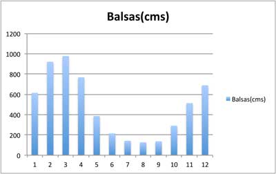
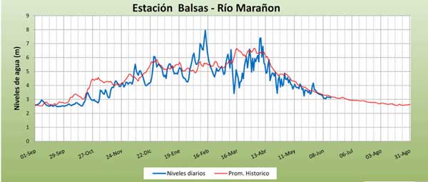
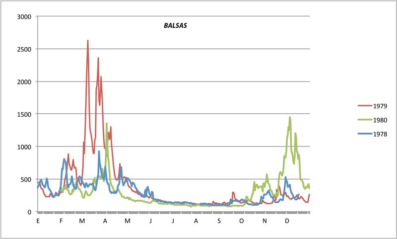
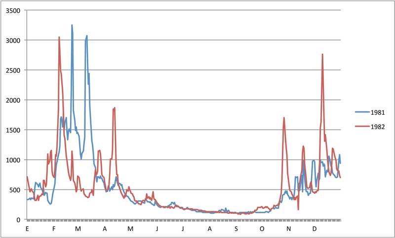
WATER LEVELS
See more info at Marañón Water Levels. By the time the Marañón reaches Balsas, it is about the same volume as the Colorado through Grand Canyon. The UpperGC section starts just past the Puchka confluence with only ~50% of this flow. While the Inner Gorge is generally too dangerous to take rafts through at higher flows (when river is running >500 cms at Balsas). However, ideal levels to line rafts through Wasson's are 200-400 cms (enough to cover many rocks but not so much to cause more flips and make recovery difficult) - generally encountered in May-June and October.
| river | Ene | Feb | Mar | Abr | May | Jun | Jul | Ago | Sep | Oct | Nov | Dic | Avg | |
| Marañon (at Balsas) | cms | 640 | 920 | 980 | 870 | 410 | 210 | 140 | 130 | 140 | 240 | 450 | 580 | 475 |
| cfs | 22800 | 32700 | 34700 | 30600 | 14700 | 7500 | 5000 | 4600 | 5000 | 8400 | 16200 | 21400 | 17000 | |
| ---------------------------- | ----- | -------- | -------- | -------- | -------- | -------- | -------- | -------- | -------- | -------- | -------- | -------- | -------- | -------- |
| Colorado (LeesFerry) | cms | 148 | 188 | 259 | 560 | 1188 | 1476 | 597 | 293 | 234 | 234 | 175 | 163 | 486 |
| [pre-dam flows 1922-1962] | cfs | 5300 | 6700 | 9200 | 19900 | 42200 | 52400 | 21200 | 10400 | 8300 | 8300 | 7500 | 5800 | 16480 |
BOATS AVAILABLE IN PERU:
[current list available]
A FEW COMMENTS FROM PAST PARTICIPANTS:
"The Marañón resembles the Grand Canyon of Colorado in many ways with its rapids, beaches, side canyons and deep cacti-studded gorges. Both rivers offer numerous side-hikes and waterfalls. Like the Canyon, the Maranon is ideal for a long multi-day boat trip where a person can forget the grind of everyday life... However, the Maranon offers much more. Unlike the Grand Canyon, the Maranon is free flowing and its character can change overnight by the whims of nature. Its navigable section is much longer than that of Colorado and its canyon is deeper. Some Maranon beaches are big enough to accommodate small villages. The Maranon offers more and greater variety of rapids that are overall more challenging to navigate. Its continuously strong current makes it possible to easily cover 30-40 miles per day in a raft, assuming one does not stop for side hikes. The jungle area of the lower Maranon has no equivalent on the Colorado... I cannot think of another river in the lower 48 States that offers the same kind of experience."
Boris Trgovcich, class IV rafter/IKer and former raft tour operator in N.California. [2013Sep Marañon trip participant]
See Full Comment
"I found the river trip labeled the "Grand Canyon of the Amazon" to be completely comparable to the Grand Canyon of the Colorado in most respects, and it exceeded my expectations in every way... In the 1980s I paddled the Bio-Bio as a participant on one of the first commercial kayak trips in Chile [with] Chris Spelius. While [the Bio Bio's] destruction was abominable both environmentally and culturally, the size and importance of the Bio-Bio's destruction was but a small warning shot compared to the potential disaster planned for the Marañón/Amazon."
Kelly Kellstadt, class III-IV kayaker and former guide/instructor in New Mexico. [2013Sep Marañon trip participant]
See Full Comment
"I need to do another expedition!!!!! I'm already jonsing for one .... The Marañon trip was one of kind that I will never forget ... the perfect combination of big water, gorgeous scenery and a taste of rurual Peruvian lifestyle! ... I would do this trip again in a heart beat ... It really is amazing how helpful some people have been along the way. Going way out of their way in order to help..."
Amie Begg; class IV kayaker on 2012 Marañon trip
"The Marañon trip was a magical journey. Big, clean water; big canyons and expansive natural beauty; and big-hearted, friendly people who made us feel welcome along the way, while sharing with us their fears of imminent dams, mines, and petroleum drilling. I hope we can find a way to help them protect this incredible treasure and their ways of life."
Barbara Conboy; SierraRios board member and rafter/kayaker on 2012 Marañon trip