DESCENTS OF THE FOUR HEADWATER STREAMS AND MAINSTEM [Rocky Contos]
In 2012, I (Rocky Contos) planned 6 months of expeditions to paddle and document the four main headwater streams of the Amazon: Ríos Apurímac, Mantaro, Marañon, Urubamba, and then the rest of the Amazon (Ene-Tambo-Ucayali). I carried GPS units down each river to obtain accurate measurement of lengths. Much of the Mantaro and a section of the Marañon had never been paddled. My descents began on May 1, 2012 on Río Mantaro and ended on Nov.7, 2012 when I stood at the mouth of the Amazon. This was the first complete descent of the river from the most distant source. More info on each river is listed below. West Hansen completed his Amazon Express journey on Dec.5, a second descent.
BOOK: First Descent of the Amazon: Click for more details about the book I am writing about the expedition. Another book, "Last Descent of the Amazon" is planned to discuss the mainstem Upper Amazon and all the dams planned to drown the river(!)
GUIDING SERVICES: Click for details on my services to guide you down any of the headwater streams of the Amazon: your dream adventure.
TOPOGRAPHIC MAPS of all rivers in Peru. These are available to friends and certain members of SierraRios.
SIERRARIOS SPOT LINK: See where the SierraRios trips are occurring now. (password: AmazonSource2012)
---------------------------------------------------------------------------------------------------------------------------------------
MEDIA:
I am available for interviews (if not on a river trip).
Contact me directly [rocky@SierraRios.org]
----------------------------------------------------------------------------------------------------------------------------------------
ARTICLES:
"OUTSIDE article: "Fastest to the Atlantic Wins"; January, 2013 [note corrections in "Comments"]
by Grayson Schaffer (editor of Outside)
OUTER LOCAL article: "Rocky Contos' First Descent of the Amazon"; Dec 17, 2012
by Tom Diegel
----------------------------------------------------------------------------------------------------------------------------------------
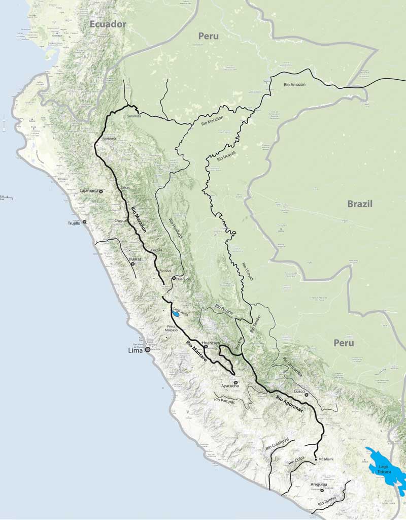
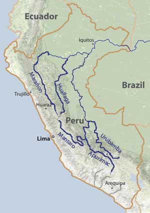
RIO APURÍMAC:
The Apurímac is considered the headwater stream of the Amazon with the actual source point up by Mt. Mismi or Mt. Quehuisha. James Duesenberry and I started kayaking the river at its uppermost point on June 11 and reached Puente Cunyac on June 24. James soon completed the river, while I did not finish until Pedro Peña joined me from Puente Cunyac to the Mantaro confluence on October 1-7. The river has many class Vs and portages, particularly in the upper "Queswachaca" section (formerly called the "Black Canyon") and also in the Acombamba Abyss.
RIO MANTARO:
James Duesenberry and I completed the first full descent of Rio Mantaro between May 1 and June 4, 2012 with Boris Trgovcich and Max Chmielinski joining us for some sections. Although Río Mantaro is one of the biggest and longest rivers in the Andes, nearly all of it was obscure to the boating community before our descent. We went into the trip only with knowledge that the final 140 km had been paddled by Richard Pethigal in October 2001. The most challenging section of river is a lower part that I call the Mantaro's Abyss, with class V rapids and several portages.
RIO MARAÑON:
Río Marañon was considered the headwater source stream of the Amazon for over 200 years, and it has a good claim to the title as it carries the most water of any branch if one progresses upstream on the Amazon from the mouth. This "mainstem source" of the Amazon has seen two nearly complete descents in the past (Wasson et al., 1977 and Biggs et al., 2004) - but neither of these groups started on Río Lauricocha, the uppermost source of the river. Kurt Casey describes much of the upper Marañon on his PeruWhitewater website. I completed a raft-support 650 km trip from the Puchka confluence down to the jungle at Imacita from July 1-28, along with my wife Barbara Conboy and two kayakers (Amy Begg and Mike Doktor). Barb and I continued down the rest of the Marañon to Iquitos, arriving August 5. Later I kayaked the uppermost Marañon on Ríos Lauricocha and Nupe down to the Puchka confluence with Tom Diegel (Aug31-Sep8). The Marañon is the best rafting Grand Canyon-style river I have ever done, and I look forward to returning to paddle it many times: see here for more info on a future trip. But there are a number of hydroelectric dams planned that will destroy the river, some in late planning stages already. Join SierraRios in the SAVE RIO MARAÑON campaign to help stop the dams.
RIO URUBAMBA:
Río Urubamba is the most sacred river of the Inca, flowing close to Cusco and by the citadel Machu Picchu. The river starts up by Lago Sabinacocha as Río Salcca and continues as Río Vilcanota before taking on the name of Urubamba near the eponymous town. The Urubamba was considered the headwaters source stream of the Amazon by various individuals starting in the late 19th century and through the 1960s before the Apurímac became established as the longer stream and therefore the true source. I kayaked most of the Urubamba starting near Combapata and continuing down by Machu Picchu to Quillabamba and to near Kiteni. I was accompanied by Simon Yerovi on the tough steep class V section from Chilca to Quillabamba. I would like to guide a raft-support descent of this river in 2013: more details.
RIO HUALLAGA:
Río Huallaga is nearly as long as the Marañon and nearly as voluminous, so it was considered the headwaters stream by various individuals and organizations in the 1800s through the 1950s. The majority of whitewater and gradient on the river are in the first 400 km above Tingo Maria. We plan to paddle a first descent on the uppermost extension of the Huallaga on a branch called Río Huertas. We also plan to paddle through Huánuco and the Great Bend, which was only first descended completely in 2009 by Matt Wilson and friends. THere is a chance we will run a raft or fast-kayak trip down the Lower Hallaga, which is mostly flat moving water but does have some class II-III rapids and canyon sections.