WATER LEVELS ON RÍO MARAÑÓN
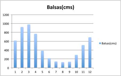
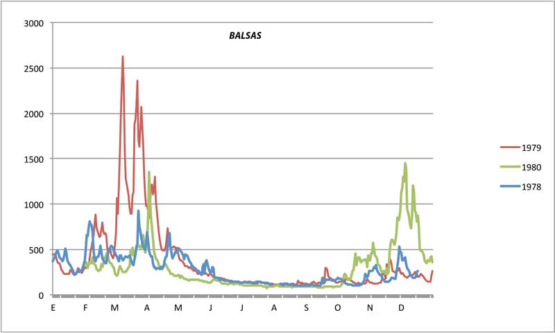
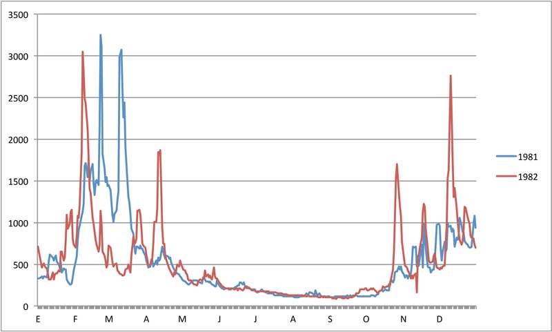
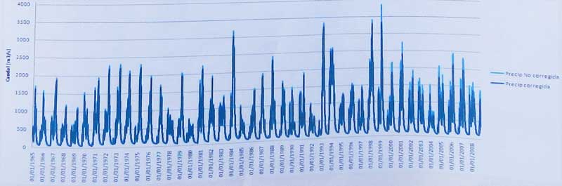
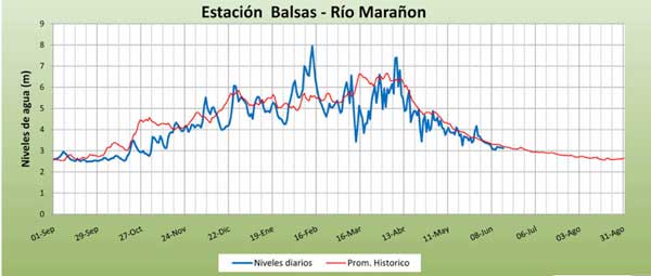
Río Marañon starts fairly small at the start of the Upper Grand Canyon section but by the time it enters the jungle it is a river ~3X as big as the Colorado through Grand Canyon. Average annual discharge at Balsas is a bit higher than the Colorado River through Grand Canyon (see comparison below). Average flows at other points are listed below in the table for both a dry-season month (July) and the highest wet-season month (March). The graphs show average river levels and actual recorded levels at Balsas. May is the start of the dry season and the river is generally at medium levels and dropping steadily. From October through April, there will likely be rain some days in the main canyon and water levels will generally be fluctuating. Flood flows have be experienced mid-October through mid-April, but are most common Dec-Apr. Note the river at Balsas most years peaks around 1500-2500 cms (53000-87000 cfs) several times between Nov-Apr, but is more typically 500-900 cms (18000-32000 cfs) during these months.
The river is runnable all year long and never gets too low. In fact, most previous descents have been at low levels Jun-Sep, which has the advantage of stable clear flows, more and larger beach camps, more smaller drops, and less chance of rain. In the rainy season (Oct-Apr), the river is usually muddy, there are bigger raft-flipping hydraulics, some rapids become very long, and potential rising river levels may mandate moving camps to higher ground at times. The Inner Gorge section is best avoided at high water due to the danger posed by the class Vs. However, the river from Chagual down is an excellent run even at high flows with numerous big Grand Canyon style rapids of class III and IV difficulty.
| river | Ene | Feb | Mar | Abr | May | Jun | Jul | Ago | Sep | Oct | Nov | Dic | Avg | |
| Marañon (at Balsas) | cms | 640 | 920 | 980 | 870 | 410 | 210 | 140 | 130 | 140 | 240 | 450 | 580 | 475 |
| cfs | 22800 | 32700 | 34700 | 30600 | 14700 | 7500 | 5000 | 4600 | 5000 | 8400 | 16200 | 21400 | 17000 | |
| ---------------------------- | ----- | -------- | -------- | -------- | -------- | -------- | -------- | -------- | -------- | -------- | -------- | -------- | -------- | -------- |
| Colorado (LeesFerry) | cms | 148 | 188 | 259 | 560 | 1188 | 1476 | 597 | 293 | 234 | 234 | 175 | 163 | 486 |
| [pre-dam flows 1922-1962] | cfs | 5300 | 6700 | 9200 | 19900 | 42200 | 52400 | 21200 | 10400 | 8300 | 8300 | 7500 | 5800 | 16480 |
If 16480 cfs average for the Colorado River sounds high, that's because it is pre-dam flows. After Glen Canyon Dam, Colorado River flows have averaged only 14200 cfs, presumably due to decreases from filling the reservoir and from evaporation.
| km | location | elevation | avg. flow July | avg. flow March | difficulty | |
| 0 | Puchka | 2130 m | 70 cms (2400 cfs) | 350 cms (12000 cfs) | IV (V) | [to Chagual] |
| 206 | Chagual | 1230 m | 120 cms (4000 cfs) | 600 cms (21000 cfs) | II-III (IV) | [to Balsas] |
| 357 | Balsas | 850 m | 140 cms (5100 cfs) | 980 cms (34700 cfs) | III-IV | [to CorralQ.] |
| 542 | CorralQ. | 390 m | 250 cms (8000 cfs) | 1200 cms (41000 cfs) | II | [to Rentema] |
| 600 | Rentema | 380 m | 600 cms (21000 cfs) | 2200 cms (77000 cfs) | III-IV | [to Nieva] |
| 788 | Nieva | 200 m | 2000 cms (70000 cfs) | 4000 cms (140000 cfs) | II-III | [to Sarameriza] |
| 872 | Sarameriza | 140 m | 3500 cms (120000 cfs) | 6000 cms (210000 cfs) | flat | [to Iquitos] |