|
RÍO MARAÑON: Jungle Pongos |
|
|
120-300 km (75-186 miles), class III, 5-10 days |
|
| launches: after end of MainGC trips: rendezvous in Jaén |
OTHER TRIPS |
Join our raft/kayak expedition as we paddle the Upper Amazon (Río Marañon) from the dry Cumba Valley into lush jungle canyon with numerous pongos (jungle rapids in canyon) and Awajún tribal communities. This trip will normally be an continuation of a Grand Canyon Amazon trip. The exhilarating class III rapids, big beach camps, verdant jungle scenery and hikes, and friendly interaction with the Awajún will be an unforgettable experience. See what a free-flowing Upper Amazon is like and help us stop numerous dams planned for the river: SAVE RÍO MARAÑON!
| INTRODUCTION |
| CLIMATE |
| ITINERARY |
| COST |
| GUIDES |
| SAFETY & HEALTH |
| FOOD, ALCOHOL, WATER |
| CHORES, TOILET, BATHING |
| WHAT TO PACK |
| WATER LEVELS |
| ----------------------------- |
| Trip reports: Sep28 Jan16 |
| ----------------------------- |
| SAVE RIO MARAÑON |
| OVERVIEW MAP :: TOPOS |
| PETITION (protest the dams) |
| ARTICLES: (AW) (IR) (C&K) |
| FILM (15 min Vimeo) |

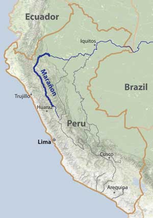
Río Marañón is the parent stream or "mainstem" source of the Amazon, and therefore is the Upper Amazon. The Jungle Pongos section follows the journey started on the Grand Canyon Amazon section, passing through more canyon that enters lush jungle. A SierraRios expedition in 2012 learned of plans for three mega hydroelectric dams that are due to flood most of this section of river and dislocate thousands. The next expeditions are intended to increase appreciation of the river and generate more awareness to help stop the dams. Voice your opinion in the SAVE RIO MARANON campaign. Sign a petition! Watch a film. Make the issue known! Support the cause with a donation! We may have a representative from International Rivers with us. The trip is open to everyone: rafters, kayakers, IKers, and passengers. No prior whitewater experience is necessary on a raft.
Our journey will start at 400 m (1320 ft) elevation in the Bagua Valley near Corral Quemado. In the first ~6 days we progress to Imacita through the majority of the difficult jungle pongo rapids. Some expeditions will continue another 6 days through the final Andean gorge at the Pongo de Manseriche and end at Sarameriza. On this journey you will meet Awajún villagers who rarely see tourists. Help them protect their villages by learning more about their way of life, their struggles, and publicizing the menace they face with mega-dam projects that will flood their villages.
Private groups are welcome to schedule a trip - either as a fully guided trip or a self-guided trip. Help us save the river and the Awajún communities!
GENERAL DESCRIPTIONS OF JUNGLE PONGOS SECTIONS
Cumba Valley
class I-II
81 km (50 miles); 2 days
Puerto Malleta (500 m) to Rentema (390 m)
1.4 m/km (7 ft/mile)
Google Maps (Balsas)
The journey generally will start in the dry Cumba Valley as a continuation of a Grand Canyon Amazon expedition upstream. The Cumba Valley section starts at Puerto Malleta and continues to Rentema. In this stretch, the river flows flat and fast (class I-II) in an arid open valley section with the canyon walls generally receding away from the river. There are numerous huge beach camps, some with protection from the afternoon winds (which are most common May-Oct). Notable points of interest along the way are numerous papaya/banana/mango orchards, the pueblo of Cumba, the Río Chamaya confluence with Baños Almendral (which offers hot water for soaking or bathing), Corral Quemado (nice to go up for lunch and get a coco helado), the surf wave and restaurants at Bellavista, and an archaeological site nearby. At the end of the valley, Río Marañón is joined by two additional large tributaries: Ríos Utcubamba (RR) and Chinchipe (RL), which generally double the flow. The Cumba Valley section ends at Rentema where the river enters a narrow canyon again.
Jungle Pongos1 (Upper)
class III+
85 km (62 miles); ~4 days
Rentema (390 m) to Imacita (300 m)
1.1 m/km (6 ft/mile)
Google Maps (Balsas)
The actual Jungle Pongos section starts at Rentema where the Marañon enters another imposing canyon section. Annual precipitation increases and vegetation quickly turns to lush jungle. Rapids in here are referred to as "pongos", a Quechua word meaning "constriction", "gorge" or "rapid". In this section to Imacita there are a dozen such big water class III pongos (some of which can be IVs if you're in the wrong place) and at least a dozen more rating class II. Whirlpools can get huge as well, causing delays and flips. Large whitewater rafts are ideal for descents of these pongos. Starting about ~40 km downstream of Rentema, the river flows by Awajún communities who do not allow people to pass without permission. The Awajún are an Amazon tribe who have their own language and have been known to be hostile to outsiders - detaining, robbing, and sometimes even killing European/American tourists (see C&K article; Outside). It is absolutely essential to have approval from them and take along Awajún guides for safe passage, something we arrange on SierraRios trips. This often leads to some of the most rewarding cultural interactions on the expedition.
See a slideshow of this section at medium water:
JUNGLE PONGOS SLIDESHOW_Sep28 [from the Sep28 (2013) trip]
JUNGLE PONGOS SLIDESHOW_Jan16 [from the Jan16 (2014) trip]
Jungle Pongos (Lower)
class I-II (III)
215 km (124 miles); ~5 days
Imacita (300 m) to Sarameriza (130 m)
0.8 m/km (4 ft/mile)
Google Maps (Balsas)
Some expeditions will continue an additional 215 km to Sarameriza, the first major port after the Marañon emerges from the Andes. In the section downstream of Imacita, the river moves quickly through canyon/gorge for ~80 km, often with class I-II riffle-type rapids, before opening up past the Pongo de Huaracayo into the wide island-studded river typical of the main Amazon basin. In here we generally stop at the port of Santa Maria de Nieva, the largest town in the region. Downstream of Nieva, the river is joined by Río Santiago (from Ecuador) and then blazes ~8 km through the final mountain range of the Andes: the notorious Pongo de Manseriche, which at higher flows sports some class II-III water that has been the ruin of many large boats attempting passage. The port of Sarameriza is located ~40 km past the final pongo. Whirlpools can get huge as well, causing delays and flips. Large whitewater rafts are ideal for descents of this section.
Gradient/Difficulty:
| km | location | elevation | avg. flow | gradient (to next) | difficulty | description of section that follows |
| -142 | Rondos | 3300 m | 40 cms (1300 cfs) | 8.2 m/km (45 fpm) | IV (V/P) | III-IV but many long V-VI (portages) |
| 0 | Puchka | 2130 m | 170 cms (6000 cfs) | 4.4 m/km (24 fpm) | IV (V) | lots of III-IV; amazing gorge; two V |
| 206 | Chagual | 1230 m | 380 cms (13000 cfs) | 2.6 m/km (14 fpm) | II (III-IV) | class II; some class III-IV start & end |
| 357 | Balsas | 850 m | 480 cms (17000 cfs) | 2.3 m/km (12 fpm) | IV | hot desert canyon; many III-IV |
| 582 | Rentema | 380 m | 1200 cms (42000 cfs) | 1.1 m/km (6.0 fpm) | III-IV | pongos: many III-IV rapids to Imacita |
| 664 | Imacita | 290 m | 1500cms (52000cfs) | 0.7 m/km (3.9 fpm) | II | class II in places |
| 788 | Nieva | 200 m | 3600cms (126000cfs) | 0.7 m/km (3.9 fpm) | I-II(III) | class I-II but III in Pongo de Manseriche |
| 872 | Sarameriza | 140 m | 4800cms (170000cfs) | 0.07 m/km (0.4 fpm) | - | flat to Iquitos (772 km) and beyond |
| 1544 | Iquitos | 100 m | 31000 cms |
Visas/Permits:
Peru is a travel-friendly country that readily offers tourist permits for up to 90 days. Flights would be into Lima. You should consider getting vaccinations against Yellow Fever, Typhoid, and Hepatitis A. Also, you will be traveling into a malaria area as well, so consider anti-malaria medication.
Personality/Experience:
You must be an easygoing person who doesn't complain much and is likely to get along with others on a Grand Canyon-style trip for an extended period. You should have an interest in river conservation and help us on our mission to document the river further, talk to residents, publicize the issue, and train local guides. Raft passengers are welcome - previous river trip experience is not required. If you want to kayak, you must have adequate class III-IV experience and a solid roll. If you want to row a raft, you must have adequate experience rowing class IV rivers. Comparable rivers are the Colorado (Grand Canyon), Middle Fork Salmon, Thompson, Futaleufu, Sun Kosi, Karnali, Omo, Yangtze (Great Bend), and Zanskar. You should be in good physical condition. You should plan to help facilitate the trip in any way possible. You don't need to be bilingual but it is helpful.
Leadership/Decisions:
The policy we will take on the trip is that the trip leader will have main authority when it comes to decisions for the group regarding river progress, camp, etc. If a participant has overestimated their ability to row or kayak, he/she may be mandated to ride on a raft. However, trip leader decisions can be vetoed by a majority vote of the group. Any participant always has the right to leave the trip if they so desire.
TENTATIVE ITINERARY [launches generally may be at the end of Grand Canyon Amazon trips]:
Day 1: rendezvous Corral Quemado; meet rafts and trip leader; protected Huanguera camp; class I; ~10 km
Day 2: enter jungle pongos; Rentema; Amojado; camp Amojado; play wave; class III; 43 km
Day 3: Amojado; El Muyo; enter Awajún areas; Tutumberos; camp at Nahém; class III; 28 km
Day 4: visit Nahém; big pongos: Cedro, Shaém, Mayasi(Sasa); camp Durucachi; class III-IV; 14 km
Day 5: layover; beautiful beach camp in the jungle; possible hike with Awajún guide to cave system; 0 km
Day 6: pass Yupicusa (potential stop); arrive Imacita; possible end and take-out; class II; ~30 km
Day 7: continue downstream through more Awajún areas; Numpatkaim; class I-II; ~40 km
Day 8: pass Chipe & Cenepa confluence; camp by Pongo de Huaracayo; class I-II; ~40 km
Day 9: arrive Santa Maria de Nieva; night in hotel; ~40 km
Day 10: visit Ideal; arrive to Manseriche huge beach camp; class I-II; ~45 km
Day 11: cave hike; pass Pongo de Manseriche (possible II-III); visit San Borja; class I-III; ~20 km
Day 12: flat wide Amazonian jungle paddle; arrive Sarameriza; hotel
Day 13: derig; 8 hr ride back to Bagua
Sites/Excursions:
At the end of this trip in Bagua you might be interested in visiting some areas such as the Catarata de Gocta (771 m high and one of the tallest waterfalls in the world) and Kuelap, the Machu Picchu equivalent of the Chacahpoyas culture (near Chachapoyas). You can also continue down to the Pacaya-Samiria reserve, where canoe trips into small flat Amazon tributaries allow an abundance of fauna to be viewed/heard.
Maps:
Rocky already has all topo maps of the entire river marked with rapids and potential beach camps. If you would like access to these, you can sign up as a member of SierraRios specifying you're interested in the Marañon map/book/video, and you'll receive immediate access to the maps (book/DVD later). If you have the password, click here to access printable maps.
CLIMATE AND BUGS:
The trip occurs at tropical latitudes in Amazon jungle at low elevations. Expect hot days and warm evenings in the initial sections (highs of 31oC/88oF and lows of 22oC/72oF are common. Average annual precipitation is >2000 mm (80 in) and almost double in areas near the Pongo de Manseriche, so expect some rainstorms at all times of the year. Rain usually falls in short intense storms.
Although many camps have no biting bugs, in some camps there are annoying biting gnats and flies. Mosquitos often come out at night. Repellent works against these. You should take precautions against bites and also possible Yellow Fever and Malaria (see Safety section below). Other critters to beware of are spiders, scorpions, snakes, and centipedes.
RENDEZVOUS POINTS/TRANSPORTATION
JAEN/BAGUA: These are two towns by the Bagua Valley section near the start of the jungle pongos section of the Marañon. Rafts will generally be arriving from the upstream Grand Canyon Amazon section. In this region, the river flows peacefully in valley, and the slope of the Andes to east and west is much lower. To get to either Bagua or Jaén, it is a ~6 hr bus ride from Chiclayo, where there are regular commercial flights (1 hr) and bus service (10 hr) to Lima. For flights, check STAR, LAN, PeruvianAir, or LC Peru. Some trips will end at Imacita where most of the big pongo rapids end. Other trips will continue down to Nieva or Sarameriza. At the end of the trip we generally will contract a ride back to Bagua - but you can continue the journey down the rest of the Amazon (to Iquitos or further downstream).
CONTRIBUTION
We strongly encourage potential participants to offer the general contribution rate if possible. See Contribution guidelines: General. Special discounts are sometimes offered to folks on our email list, so you are encouraged to sign up (Email List info). Reduced rates may also be granted to certain participants with more limited financial means. This can be to raft guides, safety kayakers, and experienced oarsmen willing to work on the trip, to others who can help with publicity and/or fill the trip, and to anti-dam activists who will be instrumental in protecting the river. Please send an inquiry to Rocky if you would like to be considered for a reduced rate, and keep in mind what basic Outfitting Services cost for a trip.
Contribution guidelines: General
RESERVATIONS
If interested in joining a trip, start a discussion by sending Rocky a note (rocky@sierrarios.org) stating how you found out about the trip and a little background info about you and your paddling experience, what dates might work for you, and what sections of the expedition you are most interested in joining. Once you get the go-ahead from Rocky, you will need to provide a deposit to reserve your place on the trip ($1000 for full trip). The balance must be received prior to trip commencement. See PAYMENTS for payment options.
CANCELLATIONS:
We reserve the right to cancel the trip 2+ months in advance. This generally will occur only if there are not enough folks signed up (<12). If we cancel the trip, all deposits and payments will be refunded.
If you must cancel, you'll get your money back if you find someone to take your place on the trip. If you don't find someone, we may allow much of the payment to be applied to a future trip (at our discretion). The amount depends on the circumstances surrounding the cancellation.
TRIP LEADERS AND TEAM MEMBERS:
(see individual trip info pages for details - links at top of MainMarañon page)
(1) Rocky Contos (scheduled trip leader on most 2014 launches), descended the entire Marañon from its headwaters on Río Lauricocha to Iquitos from July to September 2012, and led two 20+ person 30-day expeditions in 2013 (Sep28) and 2014 (Jan16). He discovered the most distant source of the Amazon [see articles C&K, Outside, Nat.Geo, FoxNews, LaRepublica] and in 2012, also paddled all of Ríos Apurímac, Mantaro, and Urubamba as part of his Headwaters of the Amazon expedition. He has explored nearly every river in Mexico including >100 first descents covering ~8,000 km of river and ~55,000 m of drop. Rocky believes the Marañon is one of the finest Grand Canyon-style raftable rivers in the South America. He is fluent in Spanish and has organized many Grand Canyon length trips. Several articles have featured Rocky (American Whitewater; Kayak Session; Canoe & Kayak). While attaining his Ph.D. in neuroscience (see CV), Rocky worked as a kayak instructor and guide for UCSD's Outback Adventures from 1993-1996 and gained valuable trip planning skills for large groups. Although primarily a kayaker, Rocky started rafting in the mid-1990s in order to introduce more people to the wonders of river travel. He has organized numerous large group raft and kayak expeditions through the Grand Canyon (7X), MF+Main Salmon River (4X), Río Mulatos-Aros (4X), Río Usumacinta (8X), Taseko-Chilcotin-Fraser (1X), and many other long trips to the Salt, Kern, Rogue, Deschutes, John Day, Thompson, Similkameen, and Baja California. Rocky founded SierraRios with the goal of conserving the rivers of Latin America, and hopes that increased awareness and enjoyment of the resource will lead to protection. He is organizing most aspects of the trips and will lead some but cannot lead all.
(2) Pedro Peña will be co-guide or trip leader on many expeditions. Pedro was born in Lunahuana near Lima and started kayaking and rafting at a young age on the Lunahuana. He has been a raft guide for most of this life on the Cañete, Apurímac, and Futaleufu. He rafted the Lower GC Amazon several times for dam survey crews but would not do so now for a love of the free-flowing river. He signed the PETITION and is working to help stop the dams.
(3) Julio Baca will be co-guide or trip leader on many expeditions. Julio was born in Curahuasi (near Cusco) and learned to paddle at a young age, advancing to class V ability in both kayaking and rafting. He lives in Cusco is typically guides the Apurimac and Urubamba in the main season (May-Sep) and then heads to the Futaleufu to guide during the season in Chile (Dec-Mar). Julio speaks English well.
(4) Lorenzo Bergamin will be co-guide or trip leader on some expeditions. Born in Milan, Lorenzo grew up near the Alps with their great whitewater and fell in love with river running and guiding. He has traveled in 62 countries and paddled/guided rivers in many areas around the world, including the Grand Canyon (several times), Futaleufu, Zambezi, Sun Kosi, Karnali, and Tamur. Lorenzo speaks English, Italian, and Spanish. He may be more permanently based in Colorado in the future.
(5) Other river guides may be employed at times, including Alonso Campana ("Rambo") a class V rafter and kayaker who joined the Upper+Middle GC Amazon trip Jan16 and runs his own rafting operation in Cusco (Apurimac Explorer), Victor Baca, a class IV-V kayaker/rafter from Cusco, Victor Memdivi ("Bacteria"), a class V kayaker/rafter from Cusco, and other Peruvian guides.
(6) Eusebio Chumpi or other Awajún will be local guides with the group in the jungle Aguaruna areas. It is not possible to pass without approval from the Aguaruna nation [you will be detained and possibly robbed/attacked] and such local guides. Eusebio or his son Manasés Chumpi joined the 2012, 2013 and 2014 trips and will likely join future trips. In addition, sometimes we will have other Awajún with us, such as Segundo Valera, and local conservationist Luciano Troyes of Gotas de Agua.
SAFETY
There is no threat from terrorists, as the Sendero Luminoso was never based along the Marañon. There is a chance we may meet some unfriendly villagers along the river in places, but nearly all residents we met in 2012 were friendly, especially when they realized we were opposed to the dams. In the jungle, the Aguaruna do not allow passage by their villages without approval. We intend to have such approval as well as Aguaruna guides along with us in these sections for safety and pleasant interactions.
The other aspect of safety is prevention of accidents. It is of utmost importance that you take all precautions necessary to avert injury, sickness, and complications while on the trip. You should be vaccinated against Yellow Fever, Typhoid, and Hepatitis A. You might consider taking anti-malaria medication if you do not plan to use insect repellent or protect yourself adequately from mosquitos. We cannot guarantee against accidents. You must accept the responsibility for what happens on the river if you are in control of your craft. If you are concerned about the whitewater or other aspects, it is your responsibility to make appropriate decisions whether to run the rapid or not and to stay close to someone who can watch and oversee you (if you desire that level of protection). If an accident occurs, we will do all in our power to help you, see that proper care is rendered, or evacuate you if need be. Rocky is a trained Wilderness First Responder. We are planning to have a satellite phone and SPOT device for communication.
KAYAKS, IKs, and RAFTS AVAILABLE FOR THIS TRIP
[current list available]
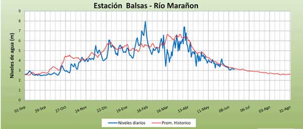
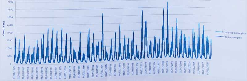
Río Marañon in the jungle pongos section starts about 3X as voluminous as the Grand Canyon Colorado, and ends at Saramariza about 12X as voluminous. This is a huge river but has very low gradient. The lower water time of year is Jun-Oct, while high water peaks around Mar-Apr. See some flow stats below (Balsas is about 1/3 the amount of water at Rentema at the start of the Jungle Pongos section. A more thorough discussion is at MarañónWaterLevels.
| river | Ene | Feb | Mar | Abr | May | Jun | Jul | Ago | Sep | Oct | Nov | Dic | Avg | |
| Marañon (at Balsas) | cms | 640 | 920 | 980 | 870 | 410 | 210 | 140 | 130 | 140 | 240 | 450 | 580 | 475 |
| cfs | 22800 | 32700 | 34700 | 30600 | 14700 | 7500 | 5000 | 4600 | 5000 | 8400 | 16200 | 21400 | 17000 | |
| ---------------------------- | ----- | -------- | -------- | -------- | -------- | -------- | -------- | -------- | -------- | -------- | -------- | -------- | -------- | -------- |
| Colorado (LeesFerry) | cms | 148 | 188 | 259 | 560 | 1188 | 1476 | 597 | 293 | 234 | 234 | 175 | 163 | 486 |
| [pre-dam flows 1922-1962] | cfs | 5300 | 6700 | 9200 | 19900 | 42200 | 52400 | 21200 | 10400 | 8300 | 8300 | 7500 | 5800 | 17280 |
| km | location | elevation | avg. flow July | avg. flow March | difficulty | |
| 0 | Puchka | 2130 m | 70 cms (2400 cfs) | 350 cms (12000 cfs) | IV (V) | [to Chagual] |
| 206 | Chagual | 1230 m | 120 cms (4000 cfs) | 600 cms (21000 cfs) | III | [to Balsas] |
| 357 | Balsas | 850 m | 140 cms (5100 cfs) | 980 cms (34700 cfs) | III-IV | [to CorralQ.] |
| 542 | CorralQ. | 390 m | 250 cms (8000 cfs) | 1200 cms (41000 cfs) | II | [to Rentema] |
| 600 | Rentema | 380 m | 600 cms (21000 cfs) | 2200 cms (77000 cfs) | III-IV | [to Nieva] |
| 788 | Nieva | 200 m | 2000 cms (70000 cfs) | 4000 cms (140000 cfs) | II-III | [to Sarameriza] |
| 872 | Sarameriza | 140 m | 3500 cms (120000 cfs) | 6000 cms (210000 cfs) | flat | [to Iquitos] |
.A FEW COMMENTS FROM PAST PARTICIPANTS:
"I need to do another expedition!!!!! I'm already jonsing for one .... The Marañon trip was one of kind that I will never forget ... the perfect combination of big water, gorgeous scenery and a taste of rurual Peruvian lifestyle! ... I would do this trip again in a heart beat ... It really is amazing how helpful some people have been along the way. Going way out of their way in order to help..."
Amie Begg; class IV kayaker on 2012 Marañon trip
"The Marañon trip was a magical journey. Big, clean water; big canyons and expansive natural beauty; and big-hearted, friendly people who made us feel welcome along the way, while sharing with us their fears of imminent dams, mines, and petroleum drilling. I hope we can find a way to help them protect this incredible treasure and their ways of life."
Barbara Conboy; SierraRios board member and rafter/kayaker on 2012 Marañon trip
"The Marañón resembles the Grand Canyon of Colorado in many ways with its rapids, beaches, side canyons and deep cacti-studded gorges. Both rivers offer numerous side-hikes and waterfalls. Like the Canyon, the Maranon is ideal for a long multi-day boat trip where a person can forget the grind of everyday life... However, the Maranon offers much more. Unlike the Grand Canyon, the Maranon is free flowing and its character can change overnight by the whims of nature. Its navigable section is much longer than that of Colorado and its canyon is deeper. Some Maranon beaches are big enough to accommodate small villages. The Maranon offers more and greater variety of rapids that are overall more challenging to navigate. Its continuously strong current makes it possible to easily cover 30-40 miles per day in a raft, assuming one does not stop for side hikes. The jungle area of the lower Maranon has no equivalent on the Colorado... I cannot think of another river in the lower 48 States that offers the same kind of experience."
Boris Trgovcich, class IV rafter/IKer and former raft tour operator in N.California. [2013Sep Marañon trip participant]
See Full Comment
"I found the river trip labeled the "Grand Canyon of the Amazon" to be completely comparable to the Grand Canyon of the Colorado in most respects, and it exceeded my expectations in every way... In the 1980s I paddled the Bio-Bio as a participant on one of the first commercial kayak trips in Chile [with] Chris Spelius. While [the Bio Bio's] destruction was abominable both environmentally and culturally, the size and importance of the Bio-Bio's destruction was but a small warning shot compared to the potential disaster planned for the Marañón/Amazon."
Kelly Kellstadt, class III-IV kayaker and former guide/instructor in New Mexico. [2013Sep Marañon trip participant]
See Full Comment