|
YANGTZE: Lower Canyon (last descent) |
|
Lower: 360 km (242 miles), class III-IV 14 days [last descent!] |
| departures: TBD (Lower) RESERVE |
| OTHER TRIPS |
The Yangtze River is the largest and longest river in Eurasia and the main river of China. It flows through one of the longest canyons in the world but already has 8 megadams on it, 3 currently under construction and 8 more planned. On this journey we will do a last descent of the Lower Canyon before two giant dams start flooding the river in June 2019. This is a last descent of the Lower Canyon gorge with its huge rapids. You might consider also joining the Upper Canyon Yangtze as well.

The Yangtze is one of the most important rivers in the world flowing through the heart of China. Although there are ~3000 km of whitewater canyon on the river, only ~1800 km remain free-flowing. On this expedition we will descend all that remains of the lower whitewater canyon of the Yangtze (Jinsha Jiang) in what is a true last descent (reservoirs start filling June 2019). The main Lower Canyon expedition will be a 14-day ~360 km last descent trip (from ~1000m elevation to ~600m elevation) starting near Panzhihua and ending just before the Baihetan Dam site near Qiaojia (Yunnan). Most of the river is class II and III but there are a several IVs and one V (that we portaged/lined last time).
This will be an historic last descent! The Lower Canyon section of river is in amazing canyon with a fair amount of rapids on a river that has ~10X the volume of the Colorado in Grand Canyon. There are two major dams nearing completion that will flood the remaining Lower Canyon section starting June 2019. We will have to vehicle portage around the Wudongde Dam site midway through this section. Last year we ware out there in May and rafted most of the “Lower Canyon” section - we were likely the first rafting group to pass through (much of the section was passed in an inflatable ball in 1986 by the Chinese groups trying to float the entire river). This year, the Lower Canyon trip will be a true last descent of an epic section of river in the world. Below are more details that can give you a better idea of the expedition.
Note: The map below shows the sections of the Yangtze that we'll be rafting/kayaking down in the Upper Canyon (~30 days) and the Lower Canyon (14 days). All other whitewater canyon sections have been drowned by hydroelectic dams. To see a more detailed map with more details on each section, click on YANGTZE MAP AND SECTIONS.
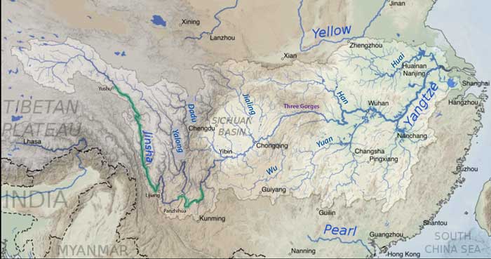
YANGTZE SECTIONS:
The Yangtze can be divided into several sections based on access points (see Yangtze Map and Sections for more):
| section | km | days | class | elevation | m/km | fpm | note |
| 1_Source | 368 | 8 | II | 5060m-4490m | 2.0 | 10 | source to float start point is ~20 km; then mostly class II and flat |
| 2_UpperTongtian | 427 | 8 | II | 4490m-4070m | 1.2 | 7 | often open flat Tibetan plain; some hills; class II max |
| 3_LowerTongtian | 347 | 7 | II-III | 4070m-3530m | 1.2 | 7 | into hills and canyon; first rapids (wide) class II and III |
| 4_Yushu | 278 | 6 | III (IV) | 3530m-3030m | 1.9 | 10 | occasional II-III rapids including a few bigger ones |
| 5_Dege | 285 | 9 | IV (V) | 3030m-2530m | 1.9 | 10 | middle section has many major rapids; Warren party aborted here |
| 6_Batang | 226 | 7 | IV (V) | 2530m-2020m | 2.0 | 11 | Wangdalong Shoals (IV); Moding Shoals (V); dam under const. |
| 7_Benzilan | 243 | 4 | II (III) | 2020m-1830m | 0.8 | 5 | some rapids for ~80 km; then gets greener and mellower |
| 8_TigerLeapGorge | 20 | 2 | V-VI | 1830m-1600m | 10 | 60 | monstrous whitewater in a confined gorge |
| 9_Great Bend | 280 | 8 | IV (V) | 1600m-1200m | 1.3 | 8 | most popular rafted section in 1990s-2000s; ALL DAMMED NOW |
| 10_Guanyinyan | 143 | 3 | II (III) | 1200m-1000m | 1.0 | 6 | pretty canyon; occasional rapids; ALL DAMMED NOW |
| 11_LowerCanyon1 | 255 | 7 | II-III (IV) | 1000m-820m | 0.8 | 4 | pretty canyon; occasional rapids; to be flooded June2019 |
| 12_LowerCanyon2 | 177 | 5 | III-IV(V) | 820m-610m | 1.2 | 7 | Laojun (V) and Baihe Shoals (IV); to be flooded June 2019 |
| 13_FinalCanyon | 401 | 8 | III (IV) | 610m-250m | 0.9 | 5 | occasional rapids ; ALL DAMMED NOW |
| 14_ChongqingValley | 701 | 12 | I | 250m-120m | 0.19 | 1.0 | no rapids ; open to shipping traffic |
| 15_Three Gorges | 332 | 6 | II-III | 120m-34m | 0.31 | 1.7 | many "shoals" rapids ; ALL DAMMED NOW (THREE GORGES) |
| 16_Final Flat | 1698 | ~30 | II-III | 34m-0m | 0.02 | 0.1 | no rapids ; open to shipping traffic |
| total: | 6232 |
====================================================================================
SECTIONS OF THE YANGTZE (Lower Canyon trip):
** (11) LOWER CANYON1 (255km; 1030m-820m; class II-III(IV); 0.8m/km; Guanyinyan Dam to Wudongde Dam): We paddled most of this section in May2018 and found a beautiful canyon with few roads but occasional villages and people, along with occasional fun class II and III rapids. The weather is very hot in May and the rest of summer. There are massive beaches in places that make for excellent camps, and some fine side hikes to do from the river. The first 40 km from Guayinyan Dam to Panzhihua is off-limits to boaters due to a nuclear power plant and other construction projects, but it is possible to start floating somewhere in the ~30 km dowstream of Panzhihua. The word from the residents is that those in the flood zone need to move out by June 2019, probably meaning the dam will start impounding water before the 2019 summer monsoon and will likely fill up the reservoir the same season.
** (12) LOWER CANYON2 (177km; 820m-610m; 1.1m/km; class III-IV(V); Wudongde Dam to Baihetan Dam): We paddled most of this section in May2018 and found a hot arid beautiful canyon with no roads for >100 km but occasional villages and people, along with occasional fun class II and III rapids and some much more challenging ones. The first big rapid is only 16 km downstream of the Wudongde Dam (~10 km downstream of our put-in point) and may be called Laojuntan. It is a big class IV wave-riddled rapid with a few holes on the far sides of the river. There’s a nice side hike to do into the RR side canyon that likely was responsible for the boulder debris that created the rapid. There’s also a nice beach here that would make a great camp. About 15km downstream of this rapid, one arrives at the massive “OldMan” or “Laojuntan” rapid, which will prompt most boaters to line or portage on the RL side. The rapid, however, goes on for ~2 kilometers with massive waves in a big water display that is unforgettable and unlike almost any other river. It is possible to walk along a thin trail on the RL side but this can be scary and dangerous (falls can happen). AFter the main rapid settles down, there are occasional class II and III rapids for another ~100 km down to past Qiaojia, a city on the RR side. Past the bridge by the city there is another ~30 km of fine river to float with some big rapids appearing again including the feared “Baihe Shoal” (aka "Xiaojun" or "Small Man" rapid), located just before the Baihetan Dam site.
BRIEF HISTORY OF DESCENTS ON THE YANGTZE (online summary: YangtzeFirstDescents):
The Yangtze saw its first serious attempts at rafting starting July 1986 when the Ken Warren expedition covered a large segment of the upper river in an intended first descent. Two competing Chinese groups (woefully unprepared) also attempted the same descent, starting 3-5 weeks before the Warren group. On the cold, high, relatively flat Tibetan plateau section, the Warren team's photographer (Dave Shippee) died from pneumonia and pulmonary edema (probably partly due to the high elevation), which amplified tension among many in his group, leading some to complain about Warren’t leadership. This, combined with the news that many in the Chinese teams were drowning and had aborted their attempt to raft the river in the Dege section, prompted four of Warren’s group to leave the expedition at Yushu. This was after ~1100 km of river had been traversed and ~4 weeks into the expedition. Warren continued with the rest of his group in the descent, successfully navigating the 278 km section from Yushu to Dege, where a few big rapids were encountered. However, about halfway through the 285 km section from Dege to Batang, they encountered severe rapids and were not able to adequately control and stop their giant “diamond-rig” of 4-rafts lashed together, so accidentally ran some rapids that should have been scouted, resulting in injuries and major damage. The problems and the fear of many more severe rapids downstream eventually prompted all in the group to hike out. The Chinese had passed into this section as well, and with flips and swimmers had some of their team members drown, which similarly prompted them to also abort. The Warren expedition ended entirely, but the Chinese teams continued to attempt to navigate the rest of the river, skipping down to Tiger Leaping Gorge for the publicity that would materialize from it. They actually were successful floating through in “unflippable” balls that could hold up to 4 team members inside. These “pods” couldn’t be controlled, but each of the two Chinese teams were successful using them to pass some team members through the major rapids in Tiger Leaping Gorge (with the most ferocious rapids of the entire river), as well as the Great Bend (with some big powerful rapids), and the Lower Canyon (including the formidable Laojun and Baihe Shoal rapids). Although initially the Chinese teams skipped much of the Upper Canyon, at least one of the teams came back months later to attempt floating it at lower water levels (with many more drownings in the Moding Shoal rapids of the Batang section). Sobek organized a rafting trip in 1987 through the Great Bend, and found it comparable in quality to a Grand Canyon journey. They subsequently organized many more expeditions in the coming two decades on this section of the river. Several other outfitters also started running trips on the Great Bend, the Yushu section, and the Qumarleb section just upstream, including Steve Currey Expeditions, Earth River Expeditions, and Last Descents. By 2011, the Great Bend was closed to rafting when several dams were nearing completion. Since 2013, the entire Great Bend section has been flooded by three dams. After that, Earth River and Last Descents ran some trips on the Upper Canyon on the section upstream of Yushu and down to Dege (but never past Dege), yet no outfitter has offered these expeditions as of 2014.
BOOKS:
If you’re going to join one of these expeditions, I highly recommend getting and reading some of the accounts of the Yangtze:
Riding the Dragon’s Back (Richard Bangs) : The most popular book describing the first descents of the Yangtze in 1986-1987, written by founder of SOBEK who also did the first raft descent of the Great Bend section in 1987 (book is from Bang's perspective and includes a comprehensive description of the SOBEK trip). The book is accurate but presents a one-sided view of the Warren Expedition mainly from interviews of those who deserted and were unhappy with Warren.
When Dreams and Fear Collide (Jan Warren) : Account by the wife of expedition leader Ken Warren (who died a few years after the 1986 descent, particularly addressing the publicized criticism of Warren’s leadership and the desertion of the group by several members.
VIDEOS:
HistoryFirstDescents_Yangtze - by Peter Winn, this video describes the history of descents of the Yangtze
VideoWarren_BuddhaHole- short video of Warren’s group including 4-boat rig going through Buddha Hole rapid (DEGE section)
VideoWarrenExpedition - short clips of news reports and some events on the Warren expedition 1986
I’m working on a more comprehensive edited video of the trips in 2018, but for now, you can see some clips that I posted on Facebook: please share!
UpperYangtze_Scenic
UpperYangtze_Rapid(III)
LowerYangtze_Whirlpool
LowerYangtze_Marty’sRapid(III)
LowerYangtze_CanyonWhirlpool
LowerYangtze_BaihetanSection
Personality/Experience/Leadership:
Participants should have some prior rafting experience as a passenger and everyone on the trip should be comfortable camping with an easygoing attitude in order to get along with a diverse group on a multi-day trip for an extended period. All participants should be in good physical condition. We welcome competent boaters, but if you want to paddle or row, you need to be an experienced class IV kayaker or oarsman with adequate experience. If you are in charge of your own kayak or raft, you are responsible for what happens to you on the water and for the equipment you use. Every participant must sign a liability waiver acknowledging the risks on the expedition and assuming responsibility.
Everyone joining these trips should have an interest in river conservation and help us on our mission to document the river further, talk to residents, and publicize the planned dams. You should plan to help facilitate the trip in any way possible, including inviting others to join the expedition and transport of some gear into the country and to the river if necessary
Visa:
You will need to get a specific Chinese tourist visa to enter China (see China_VISA). Unless you live close to one of the embassies (there is one in Los Angeles, another in San Francisco, and one in Washington DC) where you can hand-deliver your passport and leave it with them for several days with the application, you should consider sending it through a travel or passport agency to get the visa. When you get a visa it takes up a page in your passport book and is good for 10 years of multiple entries. There is a fee of $140 for US citizens. The Chinese consulate website says the turnaround time to process and get the visa is about 4 working days (I found it ready in 2 days). You do not need to be present (unless called in for an interview) - someone else can deliver your passport and the application to them such as a travel agent (see VisaExpress, Passports&Visas). You will need to know the hotel you’ll be staying in during your trip. I put this info below.
Health:
Information on health recommendations for visitors to various countries can be found at the CDC page (select the country to visit: in this case “China"). After reading this, if you're concerned about specific health issues, you may want to pay a visit to your doctor to get any recommended vaccinations or other prescriptions. In general, this area of the Yangtze has few biting insects/mosquitos and does not have malaria or yellow fever present. Aside from routine vaccinations, the CDC recommends the hepatitis A and typhoid vaccines. [though note that typhoid vaccine is only 70% effective]. Anyone going to Yushu or higher elevations (>3600 m) should consider getting a prescription of acetazolamide (Diamox) that can help prevent the development of altitude sickness.
Flights:
We are basing the Lower Canyon expedition out of Lijiang (LIJ), so this is the best city to fly in/out if you’re doing this part of the trip. Although we are tentatively planning to go straight to Chengdu at the end of the Lower Canyon trip, all participants will have the option to return to Lijiang by bus/train. For the Upper Canyon expedition, our rendezvous will be Chengdu (CTU) initially (from which we’ll all be getting a one-way flight to Yushu), but the end of the trip is in Lijiang. So you can consider RT flights into either Lijiang or Chengdu (there are numerous one-way flights each day available between these two cities). There are many low cost airfares to fly to China from the USA during this time period (as low as $381RT from LAX). Look at the itinerary to know when you’ll need to arrive and when you can depart. Usually you’ll want to arrive at least a day before the scheduled departure day (which is Day1 on the itinerary).
Currency and time:
The currency in China is the Chinese Renmibi (RMB) also known as Yuan, currently exchanging at about 6.8 RMB/USD (Mar2019). There are ATMs where you can withdraw cash but it is probably better and more certain to exchange some cash when you arrive at the airport. Larger amounts of cash may be better to exchange at a bank in Lijiang or Chengdu. [Exchange places usually will charge a flat commission so better to exchange larger sums]. The time zone of China is ~15 hr ahead that of the USA. When it’s 8am in California, it is 11pm in Yunnan. So you automatically lose almost a day when flying there, but gain it back when flying home. When looking for flights, you’ll want to try to fly there starting ~2 days before your expected arrival date. For electrical charging apparatus, the plugs in China are generally British two-prong. Most outlets in China are 220V (as opposed to 110V in the USA) so a converter is highly recommended so no electrical appliance is damaged.
RENDEZVOUS POINTS/TRANSPORTATION
LIJIANG: We will be basing the Lower Canyon trip out of Lijiang and spending several extra days there before the trip to see some of the sights (I’ll be scouting out Tiger Leaping Gorge). Lijiang is a very popular tourist destination in China and has many amenities for budget and luxury-minded tourists, as well as adventurous travelers. The city sits at ~2400 m elevation and has generally pleasant cool weather throughout the spring and summer (avg. hi/lo 24/14oC or 73/55oF for May-Oct). Monsoon rains start in May and last through October. The main attractions of the city itself are the Old Town, the Black Dragon Pools, Zhongyi market and Baimalong Pool, the Mu Mansion and various Naxi-related culture offerings such as the food, music, dance and architecture (the Naxi were the people who inhabited this area and founded the city - they were of Tibeten origin). As important as the city itself are the natural and cultural sites nearby, including the Jade Dragon Snow Mountain [Yulong Xue Shan - at 5596 m (18,500 ft), where there is a gondola going up to near the top), the Tiger Leaping Gorge of the Yangtze (tourists usually take a 1-hr bus there and hike often 1-2 days sometimes staying in a hostel enroute - see Video_HikeTigerLeapingGorge), the Baoshan Stone City (100 km northeast) and various Buddhist temples such as Yufeng Temple (the most visited and in a beautiful pine-forest setting; only ~15 km north of the city). If you’re out there, you should consider staying seeing some of these sites, and in particular the Tiger Leaping Gorge. Cycling is a great way to tour around the city and some nearby areas. .
Hotel::
Our main hotel in Lijiang will be the KTL Guesthouse (No.18 West Jibaowu, Xiabahe, Lijiang Ancient Town, 024050 Lijiang, China). It has most amenities (including wifi, hot water, and helping arrange visits to other sites), gets great reviews, is located at the entrance to the Old Town, and costs only ~$15-25/room per night. I have the equipment stored here too. While rooms may not be available through the normal booking engines (Booking.com, Agoda.com, etc), they are availalble through me by direct contact with the owner Hang Deng. I will reserve some rooms for those who are joining the trip. Otherwise you can book a room at a nearby hotel such as JiangyiGuesthouse (~$20/night), LIijiangYueTuInn (~$50USD/night), or LijiangXixiShuibaInn ($25/night). The hotel we are planning to stay at in Chengdu is tentatively the Chengdu Panda Hotel (~$35-40/night; N.209, W Hanggang Ave 1st Section, Shuangliu District, Chengdu, 610000; +86 139 0817 2105), which is near the airport and gets great reviews
Communication:
The national language in China is Mandarin - everyone speaks it and few people speak English. It is a good idea to have a translator app on your phone so you can whip out some written Chinese characters to communicate when you’re not with someone bilingual. Most hotels have wifi which is perhaps the best way to stay in touch with people back home (and otherwise) while in China. You might consider getting a SIM card for your cell phone (the phone needs to be unlocked) if you’d like to access data and calls while on the river trip with the cell network there (there will be signal at many locations). For electrical charging apparatus, the plugs in China are generally British two-prong round type or three-prong flat (see OutletTypesChina). Most outlets in China are 220V (as opposed to 110V in the USA) so a converter is highly recommended to prevent damange to electrical appliances (though some such as Apple product transformers can handle 110-240V). With regard to Internet, note that the PRC (People’s Republic of China) bans the use of Facebook and Google in the entire country due to (1) these websites allowing freedom of political expression (i.e. criticism of the government and their decisions) and (2) the companies not giving the Chinese government the right to monitor and control content. [There are alternative popular Chinese websites such as Baidu that are controlled by the PRC]. So if you’re using normal internet connections, you won’t be able to open these pages. You can still access most internet sites and your email. If you’d like to use Facebook or Google in China, you can usually get around the firewall by using a VPN (Virtual Private Network) which masks where you are accessing data from. [I use ExpressVPN but there is a fee for ther sevice (~$10/month).] On the expedition we’ll have a Garmin InReach and a satellite phone that we can use when there is no cell phone signal available..
TENTATIVE ITINERARY:
ITINERARY LOWER CANYON YANGTZE:
Day1 Drive to Panzhihua; Hotel (Panzhihua)
Day2 LOWER1: rig & start; km70-96 [km relative to Guanyinyan Dam]; Camp1
Day3 LOWER1: class III; km90-135; Camp2
Day4 LOWER1: pass Jiangbiangxiang (km147); class II; km135-180; Camp3
Day5 LOWER1: to Xiguadi beach (beautiful secluded camp before flatwater gorge); class II; km180-205; Camp4
Day6 LOWER1: Marty’s Rapid (III-IV); km205-230; class III-IV; Camp5 (take-out)
Day7 PORTAGE of Wudongde Dam (km253); Camp6 (hotel)
Day8 LOWER2: Put-in (km260) & progress 10km to Laohutan; km270; Camp7
Day9 LOWER2: run Laohutan (IV); pass worst part of Laojun(V); km285; Camp8
Day10 LOWER2: LowerLaojun(IV+); hikes on RL; near windy beach camp; km305; Camp9
Day11 LOWER2: km305-357; Camp10
Day12 LOWER2: km357-402; Camp11
Day13 LOWER2: Xiaojun(V)_Baihe Shoal; km402-423 (END) by Dam; derig; drive Xichang (5hr); Hotel Xichang
Day14 Fly out of Xichang or bus to Lijiang (8hr) or Chengdu (6hr);
Expected Progress:
We will generally paddle from ~9 am to 4 pm with some stops for side excursions. At normal May-June flows the river has low or medium flows and a good current. We will be averaging 30-50 km/day. Stops for hikes, scouts, talking to officials and local people, raft flips, and water collection do cause delays, but we should still easily cover the full distance in the allotted time provided there are not major setbacks.
Maps:
If you have provided a deposit for the trip, you can access printable maps of the river with appropriate pass codes. Topo maps span the entire river with roads, rapids, features and potential beach camps marked. Otherwise, if you would like access to the maps, you can pay a donation to SierraRios specifying you're interest in Myanmar, and you'll receive immediate access to the maps (book later).
CLIMATE AND BUGS:
The trip occurs at temperate latitudes with a general monsoonal type climate with the most rain and warmest temperatures in the summer months of June to September. There is a striking difference between the Upper Canyon (cool) and Lower Canyon (hot) due to the elevation. We require drysuits on the Upper Canyon but anything goes for the Lower Canyon (though anytime if it is raining, it can be chilly).
CLIMATE: The climate averages for Yangon (10 m elevation) which is more representative of the Final Gorge climate, and Lashio (830 m elevation) which is near the Salween in northern Shan State (but considerably higher in elevation so a bit cooler).
| Dege (3300m) | Jan | Feb | Mar | Apr | May | Jun | Jul | Aug | Sep | Oct | Nov | Dec | Avg/Total |
| AvgHigh(°C) | 8 | 9 | 12 | 16 | 19 | 22 | 23 | 22 | 20 | 16 | 12 | 8 | 16 °C |
| AvgLow(°C) | -9 | -6 | -3 | 1 | 5 | 8 | 10 | 9 | 7 | 2 | -5 | -9 | 23 °C |
| AvgPrecip(mm) | 2 | 4 | 13 | 28 | 57 | 127 | 132 | 116 | 101 | 36 | 6 | 2 | 622 mm |
| Panzhihua (1000m) | Jan | Feb | Mar | Apr | May | Jun | Jul | Aug | Sep | Oct | Nov | Dec | Avg/Total |
| AvgHigh(°C) | 22 | 25 | 29 | 32 | 33 | 32 | 31 | 31 | 28 | 26 | 23 | 21 | 27 °C |
| AvgLow(°C) | 7 | 10 | 14 | 18 | 20 | 21 | 21 | 21 | 19 | 16 | 11 | 7 | 15 °C |
| AvgPrecip(mm) | 5 | 4 | 7 | 14 | 54 | 140 | 219 | 180 | 137 | 60 | 17 | 2 | 838 mm |
BUGS / UV / SILT: UV rays from the sun are intense so it is recommended that you use sunblock liberally. This trip has few or no biting bugs. Aside from the main colder low-water winter season (Dec-Apr) the river runs with silt and will be muddy. We generally will collect and use clear side stream water for filtering/drinking, dishwash rinse, and handwash. In the event we do not have such clear water, we will use alum to settle out the silt from river water.
COST
This trip is being run because it is one of the most incredible in the world and more paddler visitation is needed to help raise awareness. More ecotourism income to the region and appreciation of the natural resource will help stop the river's destruction with dams. See current pricing and what's included at the following link: TRIP COST
Special discounts are sometimes offered to folks on our email list, so you are encouraged to sign up (Email List info).
RESERVATIONS/PAYMENTS
If interested in joining the trip, you'll need to send a note (reservations@sierrarios.org) and provide a deposit of $500 per trip (or $1000 for trips >15 days). See PAYMENTS for payment options and cancellation policy. Full contribution must be received >2 weeks before the trip. Trips may be cancelled 2 months before launch if there is not enough interest (4 full-paying participants will assure a trip occurs).
TRIP LEADER AND TEAM MEMBERS:
(1) Rocky Contos (scheduled trip leader), a former neuroscientist, is the founder and owner of Global Grand Canyons and researches, organizes and leads river expeditions for a living. In 2017, he led a first descent through the final gorge of the Nujiang in Yunnan (see video), and in 2018, he led a first controlled descent through the Lower Canyon of the Yangtze, as well as through the lower Batang and Benzilan sections of the Upper Canyon of the Yangtze. Rocky has also paddled most rivers in Peru and Mexico, and has >130 first descents mostly on rivers in Mexico, but also including rivers in Central America, Bolivia, Ecuador, Argentina, Ethiopia, Myanmar and China. Rocky discovered the most distant source of the Amazon [see articles C&K, Outside, Nat.Geo, FoxNews, LaRepublica] and completed the first full descent of this river (Mantaro) as well as the other three main headwaters of the Amazon (see Headwaters of the Amazon expedition). Rocky is fluent in Spanish, trained in swiftwater rescue (SRT-PRO) and as a Wilderness First Resonder (WFR). Several articles have featured Rocky (American Whitewater; Kayak Session; Canoe & Kayak). For more info, see Bio_Rocky.
(2) Chinese/Tibetan guides: We will have a bilingual (Mandarin/English) or trilingual guide (Tibetan/Mandarin/English - on the Upper Canyon) with us at all times.
(3) All oarsmen will be experienced river runners with extensive experience. Non-experienced and less-experienced participants are welcome to inquire about joining as raft paddlers/passengers.
SAFETY / HEALTH / INSURANCE
A major aspect of safety on this trip is prevention of sickness and accidents. It is of utmost importance that you take all precautions necessary to avert sickness and complications while on the trip. See the CDC page on China . For example, it is a good idea to be vaccinated against Hepatitis A, Typhoid, and Tetanus [however, no vaccines are required].
You should also consult the US Dept. of State page on China to be aware of current conditions in China. This is a country with various political situations that can cause restrictions of visitors and us possibly not realizing our intended itinerary. We will alwyas do our best to provide the service (or something comparable) to that intended. However, if circumstanes out of our control result in us not being able to paddle the river in full or part, we are not responsible for refunds. Because of this uncertain situation, we require all paying particpants to have a travel insurance policy to cover unexpected changes in itinerary or cancellation of trip/permits for our groups: see travel insurance policies at WorldNomads, Squaremouth, Tavelguard, or Travelsafe.
All participants must assume responsibility for themselves and sign a liability waiver before the trip. We cannot guarantee against accidents. If you're an inexperienced boater, the trip leader and guides will advise you on saftey issues. If you are an experienced boater in control of your craft, you must accept the responsibility for what happens to you on the river. It is the experienced boater's responsibility to make appropriate decisions whether to run the rapid or not and to stay close to someone who can watch and oversee you. A certain level of freedom will be provided, but each such person must abide by trip leader requests, which may mandate not paddling certain rapids. If an accident occurs, we will do all in our power to help you, see that proper care is rendered, or evacuate you if need be.
We will have an Inmarsat satellite phone ($1.20/min for calls) and probably a Garmin InReach device. We will also have at least one cell phone operating that can be used when there is signal available (cell signal is widespread even in fairly remote areas of China).
lThe Jinsha Jiang flow varies greatly through the year with stable low flows generally encountered from Dec-May, and peak flows (usually ~8X that of the low flow months) from July through September caused by both snowmelt and summer monsoon rains. At Zhimenda Bridge (by Yushu) the river averages ~405 cms (14400 cfs) which is the same flow as the Colorado in Grand Canyon. In May and June, we can expect low flows with a rising river going from ~250 cms to ~600 cms (as opposed to August when the flow is ~1000 cms). In the next ~1000 km, tributaries add signficantly to the flow, to the point where at Tiger Leaping Gorge and the Great Bend, the Yangtze averages about 1400 m3/s or 50,000 cfs (about 4X the flow of the Colorado). In May-June, the flow by Tiger Leaping Gorge is generally increasing rapidly from an average of ~1000 cms (35000 cfs) to 2000 cms (70000 cfs). The Yangtze in the Lower Canyon section receives a huge boost of water from the Yalong river that joins at Panzhihua (to an average flow of approximately 3500 m3/s or 120,000 cfs). Usually in May, the river averaged ~2000 m3/s or 70,000 cfs with generally rising levels. However, flows on the entire section are now regulated by the dams upstream, but the reservoirs created by these dams have relatively low storage capacity. In May, flows should be low and similar to last year, or ~2000 cms (70,000 cfs), which is roughly what the natural flow was. With the rains starting, it may start turning more turbid/brown. This is a HUGE RIVER with ~10X the volume of the Colorado in Grand Canyon and is similarly confined in a narrow canyon, so it doesn’t take much gradient to make it pretty exciting with rapids.
| Station | Ene | Feb | Mar | Abr | May | Jun | Jul | Ago | Sep | Oct | Nov | Dic | - | Avg | |
| Yangtze (Yushu) | cms | 90 | 90 | 90 | 180 | 290 | 650 | 1050 | 1100 | 900 | 450 | 180 | 90 | - | 410 |
| cfs | 3200 | 3200 | 3200 | 6400 | 10300 | 23000 | 37200 | 39000 | 32000 | 16000 | 6400 | 3200 | - | 14500 | |
| ----------------------- | ----- | -------- | -------- | -------- | -------- | -------- | -------- | -------- | -------- | -------- | -------- | -------- | -------- | - | -------- |
| Yangtze (Shigu) | cms | 350 | 340 | 390 | 680 | 1120 | 2370 | 3220 | 3300 | 2510 | 1450 | 680 | 480 | - | 1390 |
| cfs | 11000 | 11000 | 13000 | 22000 | 40000 | 84000 | 114000 | 117000 | 89100 | 51400 | 24000 | 17000 | - | 49300 | |
| ----------------------- | ----- | -------- | -------- | -------- | -------- | -------- | -------- | -------- | -------- | -------- | -------- | -------- | -------- | - | -------- |
| Yangtze (Pingshan) | cms | 1610 | 1390 | 1300 | 1450 | 2250 | 4940 | 9510 | 10500 | 9910 | 6440 | 3460 | 2150 | - | 4570 |
| cfs | 57000 | 49000 | 46000 | 52000 | 80000 | 175000 | 337000 | 373000 | 351000 | 229000 | 123000 | 77000 | - | 162000 | |
BOATS AVAILABLE IN CHINA:
Boats available in China can be viewed at BoatsChina:
A FEW COMMENTS FROM PAST PARTICIPANTS:
"The Yangtze is incredible - even with the low gradient, it still has many rapids, and can be passed by seasoned class IV big water boaters. The big water rapids are truly an experience unlike any other river I've been on with big whirlpools that spin you around at the end. Bugs were almost non-existent, and beach camps enormous. I loved every day of the Yangtze expedition!."
Rocky Contos, class V explorer who did rafted Yangtze Lower Canyon in 2018 and part of Upper Canyon in 2018.