|
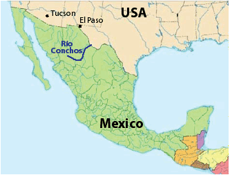
RÍO CONCHOS: Beautiful Rio in the Sierra Tarahumara |
|
197 km (122 miles, class III+, 12 days) |
| departures: Sep1 (2024) . RESERVE NOW |
Join an expedition down one of the most scenic rivers in Mexico just south of the New Mexico/Texas border! Enjoy beautiful canyon with unique pillars, interesting caves, fun rapids, and hotsprings in Tarahumara land. Everyone is welcome: raft paddlers/passengers, kayakers, oarsmen, and IK/packrafters. This is generally a class III trip suitable for intermediate kayakers though there are 2-3 class V passages to get through (portaging/lining). This trip is usually preceded by the more commonly organized Tutuaca-Aros trip (with more reliable flows).
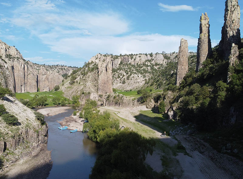
This trip on Río Conchos will start in Chihuahua with a drive to the put-in at Tehuerichi located near Creel in the heart of beautiful high altitude Tarahumara country. After a day exploring Arroyo Hondo and the pillars and caves there, we will launch the rafts and continue for 9 days into the central Chihuahuan desert through some of the most dramatic scenery and interesting sites in Mexico. You'll get a good feel of the Copper Canyon region on this trip and get to enjoy the incredible scenery, explore bizarre rock pillars, camp in sheltered caves, view abandoned cliff dwellings, hike interesting arroyos, meet Tarahumara, and navigate some fun rapids. We will run as much of the river as possible, most likely starting at Tehuerichi and continuing down through Cascada Conchos, the Red Gorges section and Cañon Ciriacos. Most of the bigger rapids are class III, though there are two rapids that we generally will line the rafts through (Cascada Conchos and Inesperado, both class Vs). We'll likely end our trip just before the final major catract on the river (class V Laborcita). We expect to have several large rafts to accommodate the group and passengers, though as on all our trips, competent paddlers can reserve a kayak or IK: bring your own boat or use one of ours.
TENTATIVE ITINERARY:
DAY 0: participants arrive to Chihuahua; welcome dinner; stay night in hotel (Chihuahua)
DAY 1: Conchos: drive to Tehuerichi; start rigging rafts; class II; km 0
DAY 2: Conchos: Upper: optional hike/paddle Arroyo Hondo section (Pilares); class II; km 0 (+10)
DAY 3: Conchos: Meanders: launch with rafts; meanders, caves and canyon walls; class II; ~km 10
DAY 4: Conchos: Meanders; to Cascada Conchos (line/walk); class III; ~km 25
DAY 5: Conchos: Meanders; paddle fun rapids just downstream; hot springs; class IIIs; ~km 40
DAY 6: Conchos: Red Gorge; pass Puente Baqueachi; Inesperado (class V/P); class II-III; ~km 50
DAY 7: Conchos: Red Gorge; super fun class IIIs (a little IV); class III-IV; ~km 65
DAY 8: Conchos: Red Gorge; more IIIs; easier day with faster progress; pass Nonoava & puente; ~km 80;
DAY 9: Conchos: Ciriacos ; into beautiful canyon with decent volume (avg ~80 cms/~2500 cfs); ~km 110
DAY 10: Conchos: Ciriacos; lots of class IIIs in pretty canyon; class III; ~km140
DAY 11: Conchos: Ciriacos; mostly class II in pretty canyon; to near Balleza confluence; class II-III; ~km 175
DAY 12: Conchos: Ciriacos last part; optional Laborcita; km 197; hotel (Chihuahua)
DAY 13: possible flight home (Chihuahua) or Copper Canyon train to Creel or farther
Total Conchos trip length : 197 km or 273 km
54 km CascadaConchos (Tehuerichi to Puente Baqueachi)
39 km Red Gorge (Puente Baqueachi to Puente Agua Caliente)
94 km Ciriacos (Puente Agua Caliente to Puente Laborcita)
76 km Valle de Zaragoza (Puente Laborcita to Valle de Zaragoza)
Note: if water levels are medium to high, we will progress more rapidly and probably continue the trip 76 km extra to Valle de Zaragoza (and may even put in a layover day) . If water levels are low, we will likely just do the indicated itinerary .
COST
We welcome everyone on the trip: raft passengers, raft paddlers, raft rowers, kayakers, IKers, and guides. No prior rafting experience is required to join a trip. We offer professional level service similar to other established outfitters. The general costs of this and other trips and what's included are listed at: TRIP COSTS
RESERVATIONS
If interested in joining a trip, start a discussion by sending a note stating how you found out about the trip and a little background info about you and your paddling experience. Once you get the go-ahead, you will need to provide a deposit to reserve your place on the trip. The balance must be received 2 weeks prior to trip commencement. See PAYMENTS for payment options.
HEALTH
(click here)
FOOD/ALCOHOL/WATER
(click here)
CHORES, TOILET AND BATHING
(click here)
WHAT TO PACK
(click here)
SAFETY
The violence in Mexico surrounding the drug was has been in the news a lot in the past three years. The violence is confined to drug traffickers (narcos) and those associated with them, including law enforcement. In addition, the river we will be journeying down did not have any marijuana cultivation visible near it and goes through Tarahumara country rather than narco countr. As such, we are not likely to be harassed or molested in any way related to the drug war. For further discussion of the drug war and safety concerns, click here.
WATER LEVELS
We have timed this trip to coincide with highest probability of good river flows. Trips on the Conchos will generally be scheduled only in August and September when highest probability of finding fun floatable flows. Although the river averages only ~20 cms (700 cfs) at the put-in of Tehuerichi in these months, you don't need a lot of water to float this river over the smooth bedrock riverbed, but if flows are very low, it will be very difficult to get large rafts down. After the confluence with Río Carichi/AguaCaliente, the flow averages ~50 cms and there will almost always be enough water for rafts in Aug-Sep. With the added water of Río Nonoava farther down, the river averages ~80 cms (2600 cfs) in Cañon Ciriacos. If water levels are low , we all will go to Puente Baqueachi and start there with the rafts for the Red Gorges and Ciriacos sections. Water levels can fluctuate rapidly due to spotty intense thunderstorms that are characteristic of the monsoon season in the region. It is important that rafts be tied up well so they don’t drift away in a rising tide on the river. Equally important, the camp must be set at a high enough location so it will not be flooded. We may encounter rapidly rising river that reaches camp (usually in the evening). If this happens and you are the first to notice, please wake the guides first, and we will assess the situation. It may be necessary to move camp higher.
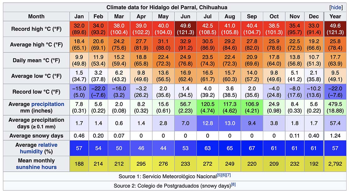
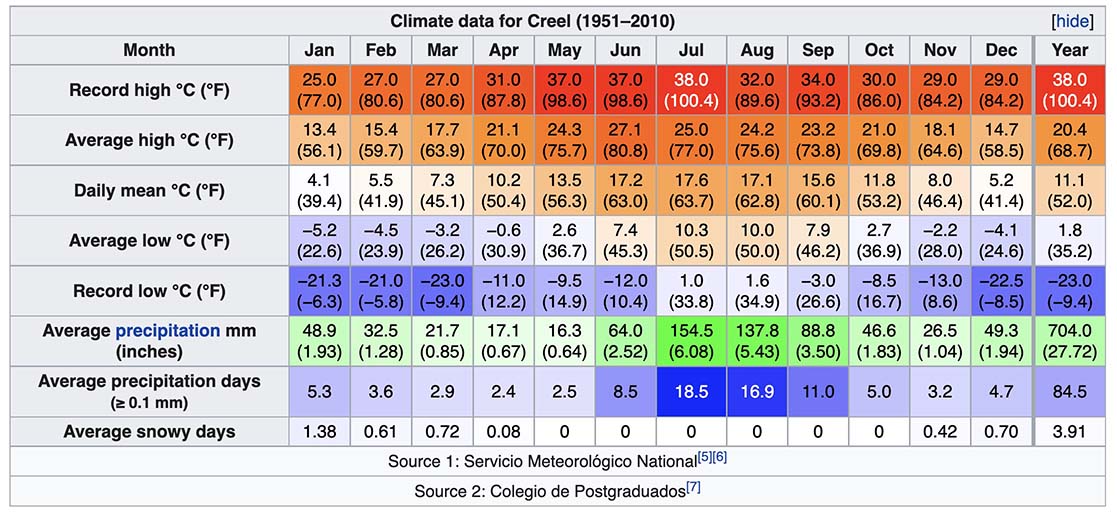
CLIMATE
This trip is at fairly high elevation, starting appx. 1800m (5000 ft) and ending ~1000m (3300 ft), and due to this, the nights are generally comfortably cool on this trip and days are warm (sometimes it feels hot if the sun is shining). Much of the trip is at approximately the same elevation as Hidalgo del Parral (1400m) so the climate averages for that nearby city are representative for what you might experience on this river. Closer to the start of the trip, it will be more like Creel weather, and toward the end, hotter than Parral (due to elevation changes). We only run this trip in the rainy season, so we generally will experience thunderstorms and rain on some evenings.