AN EXPEDITION TO DESCEND THE FIVE MAIN HEADWATER STREAMS OF THE AMAZON
Rocky Contos and friends: [more about Rocky Contos here]
This is an exciting time to be paddling in Peru. After an extensive cartographic analysis of rivers in Peru, coupled with great information from CanoAndes and Kurt Casey, I planned a 4-month expedition to paddle and document the five main headwater streams of the Amazon: Ríos Apurímac, Marañon, Mantaro, Urubamba, and Huallaga. Most of the Mantaro, and sections of the Marañon, Huallaga, and Urubamba will be first descent. After these trips, I will help West Hansen get through the whitewater in his AMAZON EXPRESS bid to be the fastest ever to descend the entire Amazon source-to-sea. I will post updates of the expedition periodically. Please let me know if you are interested in the venture and also in the book that I plan to write about the expedition. Click here to see all annotated TOPO MAPS of Peruvian Rivers: only available to SierraRios friends/reviewers. There is a possibility to become a part of this expedition as a member of the raft-support Marañon trip. Also, you might be interested in other raft support trip possibilities in Mexico listed on the main SierraRios homepage. You can see where we are located over the previous 7 days at the SPOT link here. Contact me for password. Press/Sponsors: Please consider sponsoring or donating to this effort. If interested, please contact me directly. |
 |
THE RIVERS:
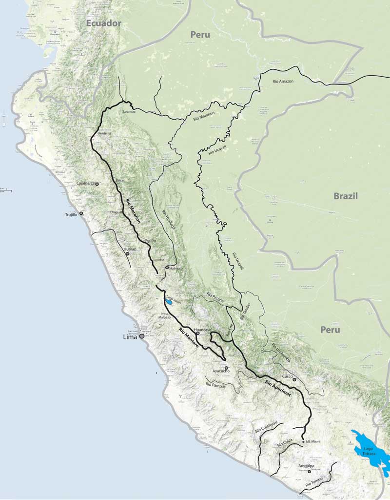
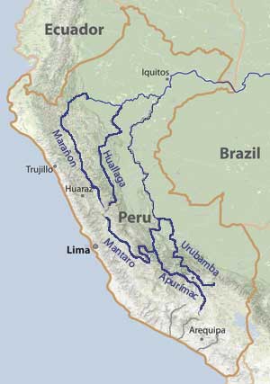
APURÍMAC: The Apurímac is considered the headwater stream of the Amazon with the actual source point up by Mt. Mismi or Mt. Quehuisha. We will start kayaking on Río Hornillos in May and take ~16 days to travel ~630 km down to San Francisco. There are some difficult class V sections in the and the Acombamba Abyss, in addition to the excellent first and second class III-IV rafting section. My partners will be James Duesenberry and Boris Trgovcich, and we may meet Kurt Casey, Leonardo Gonzalez, and/or Gian Marco Vellutino for parts.
MANTARO: Although Río Mantaro is one of the biggest and longest rivers in the Andes, nearly all of it remains obscure to the boating community. The only part that has been paddled and described at all is the lower 140 km, when Richard Pethigal made a descent in October 2001. However, he and his two partners portaged a ~15 km box canyon that spooked them due to the big water, vertical walls, and class IV-V rapids they were already encountering. We plan to paddle through not just this unrun box canyon, but also hundreds of kilometers of unrun river upstream. My main partner will be James Duesenberry, with Boris Trgovcich and Max Chmielinski joining us for some of the upper parts.
MARAÑON: Río Marañon was considered the headwater source stream of the Amazon for over 200 years, and it has a good claim to the title as it carries the most water of any branch if one progresses upstream on the Amazon from the mouth. The river has seen two nearly complete descents (Wasson et al., and Biggs et al) - but neither of these groups started on Río Lauricocha, the uppermost source of the river. Kurt Casey describes much of the upper Marañon. James Duesenberry and I will paddle the class V uppermost section of the Marañon in kayak, while for the class IV section from the Puchka confluence down we will have more ofa Grand Canyon-style raft-support trip with Barbara Conboy, Boris Trgovcich, Amie Begg, and possibly others along. This trip is open for others to join, so please check out the info and let me know if you're interested.
HUALLAGA: Río Huallaga is nearly as long as the Marañon and nearly as voluminous, so it was considered the headwaters stream by various individuals and organizations in the 1800s through the 1950s. The majority of whitewater and gradient on the river are in the first 400 km above Tingo Maria. We plan to paddle a first descent on the uppermost extension of the Huallaga on a branch called Río Huertas. We also plan to paddle through Huánuco and the Great Bend, which was only first descended completely in 2009 by Matt Wilson and friends. THere is a chance we will run a raft or fast-kayak trip down the lower Lower Hallaga, which is mostly flat moving water but does have some class II-III rapids and canyon sections.
URUBAMBA: Río Urubamba is the most sacred river of the Inca, flowing close to Cusco and by the citadel Machu Picchu. The river starts up by Lago Sabinacocha as Río Salcca and continues as Río Vilcanota before taking on the name of Urubamba near the eponymous town. The Urubamba was considered the headwaters source stream of the Amazon by various individuals starting in the late 19th century and through the 1960s before the Apurímac became established as the longer stream and therefore the true source. We plan to paddle most of the Urubamba from Río Salcca down to Kiteni (the lowermost easy road access point and end of the majority of whitewater). Joining me on the tougher class V sections will be James Duesenberry, Leonardo Gonzalez (in May: Tonontei Gorge/MachuPicchu section), while the easier sections I plan to complete with Erik Weihenmayer+friends/family (in August: Valle Sagrado and Quillabamba sections).
PLANNED ITINERARY
Apr26: Arrive Lima late
Apr27-29: Look for raft frame parts, buy food; deal with other logistics in Lima: others arrive
Apr30-May18: Mantaro (full descent)
May19-21: Travel to Arequipa (1 day to Ayacucho; 7hr to Pisco; 13hr to Arequipa)
May22-25: Tambo
May27-Jun13: Apurímac (630 km; Hornillos to San Francisco)
Jun14-16: travel to Ayacucho, Huancayo, Yanahuanca
Jun17-23: Huallaga
Jun25-30: Upper Manañon (Lauricocha to Puchka confluence)
Jun30-Jul24: Main Marañon (Puchka confluence to Chiriaco/Nieva)
Jul25--28: visit Keulap; return to Lima; maybe other
Jul29-Aug21: to Cusco; Machu Picchu/Río Urubamba
Aug22-Sep3: AMAZON EXPRESS : guide West Hansen down whitewater
SPONSORS
CanoAndes: CanoAndes and main member Piotr Chmielinski are supporting the expedition. Piotr was the first man to ever paddle the Amazon source-to-sea and is quite interested in the Headwaters of the Amazon expedition and supporting it both financially and in many other ways.
National Geographic: The financial and media support from National Geogrphic for one part of the overall expedition is greatly appreciated.
MORE DETAILED MAP: