|
SALWEEN (THANLWIN): Great Canyon of Burma |
|
390 km (242 miles), class II-III (IV) 12 days [first descent!] |
| departure: Mar14 (2020) RESERVE |
| OTHER TRIPS |
The Salween River (also called Nujiang or Thanlwin) is one of the major rivers emerging from Tibet, flowing into Myanmar (Burma) through one of the longest canyons in the world. On this journey we will be on a huge volume river but with very low gradient, with only occasional class II and III rapids (though there may be some IVs). We will camp on fine beaches, play in the warm clear side streams, meet the Shan, Wa, Pa-o, Karenni, Karen, and Palaung people who live nearby, and admire the interesting flora and fauna. In 2018 we will complete the first descent of the final gorge with its huge rapids.
The Salween River (called Thanlwin in Myanmar) is one of the great rivers emerging from Tibet. It passes through Yunnan and Burma (Myanmar) enroute to the Indian Ocean through one of the longest canyons in the world. The river in Myanmar is generally flat moving water in a canyon with occasional class II and III rapids, and a few IVs. In 2016, we rafting the middle ~300 km section of the river in Myanmar (see slides3 and slides4). In 2018, our itinerary will be to raft down this incredible river on what will be the first descent of the Lower Gorge section, which has >40 big water rapids (avg. flow 5000 cms or 170000 cfs) and is the reason that no motorboats go upstream from Karmarmaung near the coast.
Join us for a raft/kayak descent of this Grand Canyon-style river in Myanmar and experience one of the few tropical wilderness rivers that remain in the world! Paddle through the monsoon jungle and see the interesting flora and fauna along the way. Help us in our mission to publicize the plight of this incredible river with the series of proposed megadams to be constructed. Sign the PETITION and come see for youself what an incredible river the Salween is. For more info, email an inquiry to reservations@sierrarios.org.
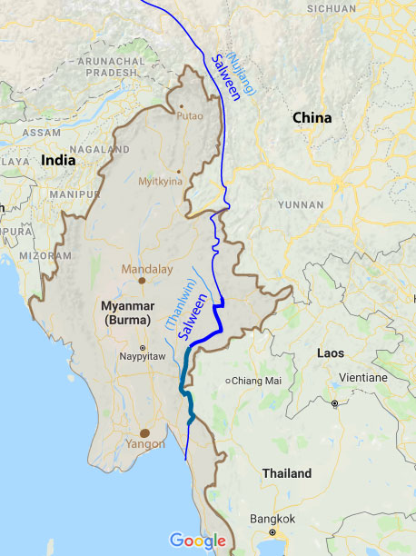
Note: The map to the right shows the middle sections highlighted (dark blue) - from NawngAwn-to-TarSang and TarSang-to-Ta HsopTeng. The first descent trip in 2018 will cover the final section of the canyon from TaHsopTeng to Karmarmaung (teal blue). We also plan to paddle the NamPang again and the final gorge of the NamTeng.
| Photos of rivers in Myanmar: | NamPawn (2016) |
| Doktawaddy1 (2015) | NamTeng (2016) |
| Doktawaddy2 (2016) | NamPang (2016) |
| NamPang (2015) | Thanlwin3 (2016) |
| NamTu/NamMa (2015) | Thanlwin4 (2016) |
SALWEEN SECTIONS:
The Salween can be divided into several sections based on access points:
| section | km | days | class | elevation | m/km | fpm | note |
| 1_Border | 144 | 4 | III-IV | 570m-450m | 0.83 | 4.6 | 35 km along border with some big rapids; then class II-III |
| 2_Upper | 375 | 5 | IV | 450m-260m | 0.51 | 2.8 | beautiful canyon with occasional class II and III; NEVER PADDLED! |
| 3_TarHsai | 132 | 6 | II-III | 260m-206m | 0.41 | 2.3 | easy section with some rapids; NamPang layover/hike is a highlight |
| 4_TarSang | 154 | 6 | III (IV) | 206m-132m | 0.50 | 2.6 | many rapids, including Granite Nautiloid (IV+) ; one of the funnest! |
| 5_TaHsopteng | 154 | 5 | II | 132m-100m | 0.21 | 1.2 | easy section; mostly flat moving water; NEVER PADDLED! |
| 6_FinalGorge | 236 | 7 | III (IV) | 100m-13m | 0.37 | 2.0 | Final gorge with dozens of rapids; NEVER PADDLED! |
====================================================================================
1_Border section
class III-IV
144 km ; ~4 day
Myamar border (570 m) to Kunlong (450 m)
0.83 m/km (4.6 ft/mile)
avg flow ~2000 cms (70000 cfs)
The Border section has not been rafted or kayaked as of 2018, aside from the intial part that was descended by raft in May2017 coming down from China (Rocky Contos, Martin Brenner, and Lolita - see Video). It is difficult to access the border area, but once there, it should not be a problem continuing down to Kunlong, where there is major highway access to the river and a bridge.
2_Upper section
class III
375 km ; ~10 days
Kunlong (450 m) to NawngAwn (260 m)
0.51 m/km (2.8 ft/mile)
avg flow ~2500 cms (89000 cfs)
This section of the Salween goes through the more troubled Northern Shan State where there has been conflict in the recent past and past decades. There are Wa, Northern Shan State, and Kachin soldiers in the area. The rapids seem to be interspersed through the section with mostly class II and III, and it looks to be ideal for a longer rafting expedition.
3_TarHsai section
class II-III
132 km ; ~6 days
NawngAwn (260 m) to TarSang (206 m)
0.41 m/km (2.3 ft/mile)
avg flow ~3000 cms (106000 cfs)
This section has easy road access from Inle Lake/Kunhing to the bridge at NawngAwn, but as all of the river, it is in restricted area so you need special permits to arrive. The river starts out with good current and some smaller rapids of class II and III difficulty in a pretty canyon down to the highlight of this trip: the confluence of the NamPang (called Tar Hsai). The NamPang is a clear travertine-depositing tributary entering on RR with one of the biggest river beaches in the world formed by a massive eddy at high water. It is always a delight to spend a full day here getting to know the local Shan people and taking a hike (possibly with kayaks) up the NamPang and paddling down the final few kilometers of falls and rapids. The NamPang enters the Salween in a bang with either a major class IV rapid or a ~8m waterfall, both of which are runnable. After the confluence, the river continues pretty flat through a lovely canyon (Asian elephant spotted in here) to the road and bridge access at TarSang. Throughout this section one will find gold-dredging barges, often manned by illegal Chinese who split the earnings with rebel armies. The first descent by raft or kayak was completed in May 2016 by Rocky Contos, Kurt Casey, Josh Fisher, Vern Nelson, Matt O'Brien and Htet Ye Aung (Chris).
See a slideshow of the first descent of this section: Slideshow: THANLWIN (TarHsai section) [2016]
4_TarSang section
class III (IV)
154 km ; ~6 days
TarSang (206 m) to Ta Hsopteng (132 m)
0.51 m/km (2.6 ft/mile)
avg flow ~3400 cms (120000 cfs)
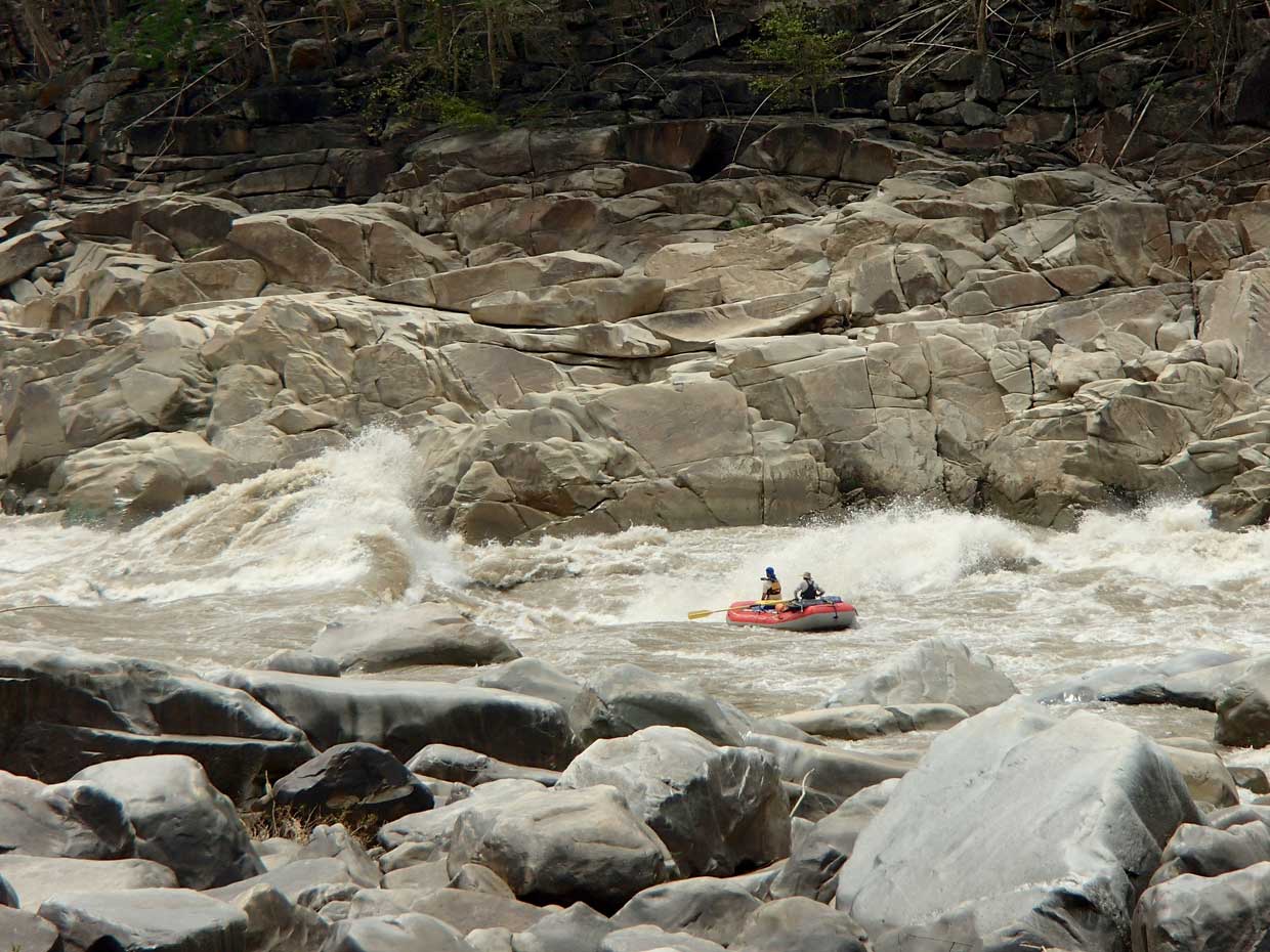
The TarSang section starts at the TarSang bridge where one of the megadams is planned for the Salween. Only 20-30 km downstream enters one of the roudiest sections of the Salween in Myanmar, with over a dozen rapids of class II, III and IV. The toughest rapid is the Granite Nautiloid, a class IIV-V that can be skirted on the RL side by kayaks and rafts. The huge waves and holes on the RR side can easily flip even 20+ ft rafts and are equivalent to Crystal on the colorado at 50000+ cfs (see Video). There are incredible giant beach camps and interesting people to meet along the way, including the Wa and Pa-o, in addition to Shan. Don't venture down here without permission from the Wa, or you'll be detained indefinitely. The section ends at Ta Hsopteng, the confluence with the Nam Teng river, where a road descends from Langkho and a ferry crossing is manned. The first descent by raft or kayak was completed in May 2016 by Rocky Contos, Kurt Casey, Josh Fisher, Vern Nelson, Matt O'Brien and Htet Ye Aung (Chris).
See a slideshow of the first descent of this section: Slideshow: THANLWIN (TarSang section) [2016]
5_Ta Hsopteng section
class II
154 km ; ~5 days
Ta Hsopteng (132 m) to Hpasawng (99 m)
0.21 m/km (1.2 ft/mile)
avg flow ~4000 cms (142000 cfs)
The Ta Hsopteng section begins at the confluence of the Nam Teng river, and if starting here, it might be nice to paddle the final class II-III section of the tributary before entering the huge easier Salween. The river continues through canyon but with few rapids - some that might be class II. As of March 2018, this section has NEVER BEEN PADDLED. We intend to raft and kayak the first descent in Apr-May2018 should we get the permit.
6_Final Gorge section
class III (IV)
236 km ; ~6 days
Hpasawng (99 m) to Karmarmaung (13 m)
0.37 m/km (2.0 ft/mile)
avg flow ~4500 cms (160000 cfs)
The Final Gorge section of the Salween passes through the final canyon and gorge on the river before it empties into the Indian Ocean. It straddles the border with Thailand for about 30 km and a national park there. The main rapids are located in the final ~80 km of the river and have never been paddled by modern whitwater boaters. These rapids present a major obstacle to anyone attempting to navigate the river upstream from the ocean, and have isolated most of the river and its beautiful canyon for centuries. This is possibly the nicest section of the river to paddle in Myanmar, and perhaps one of the finest in the world. With a massive average flow of ~4500 cms (150,000 cfs) it is sure to have some amazing whirlpools, currents, waves, eddies and beaches. Clear sidestreams with waterfalls should be a delight to visit and wash/bathe in. There are Karen and Karenni people living along the way, as well as Thai and many others. A giant dam is planned for the gorge that would flood these amazing and fun rapids and negatively affect the residents in the area. Sign the PETITION. Join us and be the first to navigate one of the most impressive rivers in the world!! As of March 2018, this section has NEVER BEEN PADDLED. We intend to raft and kayak the first descent in Apr-May2018 should we get the permit.
7_Coastal Plain section
class I (flat)
157 km ; ~3 days
Karmarmaung (13 m) to Indian Ocean (0 m)
0.08 m/km (0.5 ft/mile)
avg flow 5000 cms (170000 cfs)
The Coastal Plain section is the final section of the Salween (Thanlwin) before it empties into the Gulf of Martaban (Indian Ocean). It is flat moving water and subject to tides in the lower part. About 100 km downstream of Karmarmaung, the river passes the major city of Mawlamyine, which can be a take-out point, but you can also continue 40-60 km further to the actual Gulf, where you'll have to find a road to the beach to take you back to Mawlamyine and Yangon.
====================================================================================
PRIOR DESCENTS:
The Salween in Myanmar has been in restricted territory since the 1950s when the military junta took control of the country and ethnic peoples in the surrounding areas of the territory formed militias and armies. These standing armies are still in existence and at odds with the main Burmese army (Tatmadaw). Although many areas are at peace with cease-fires, in order to pass in this zone one needs permits from the central Myanmar government, as well as permission from each of the ethnic rebel groups. Due to the difficulty of obtaining such permissions, no modern rafting or kayaking groups had descended the river until 2016 when permission was sought and obtained for Rocky Contos with a group organized through SierraRios to raft and kayak the middle section of the river (May2016). This first descent journey was the first foray into the Thanlwin in Myanmar, during which it was determined that despite the low gradient, there are plenty of interesting rapids on the river, and the isolation and lack of development makes it one of the most special places in SE Asia. The river needs to be publicized, more people brought to it, and a movement started to help the local people oppose the series of mega-dams that Chinese and Thai private interests seek to construct. Sign the PETITION against these dams.
Personality/Experience/Leadership:
Participants need no prior rafting experience as a passenger but everyone on the trip should be comfortable camping with an easygoing attitude in order to get along with a diverse group on a multi-day trip for an extended period. All participants should be in good physical condition. We welcome competent boaters, but if you want to paddle or row, you need to be an experienced class III or IV kayaker or oarsman with adequate experience. If you are in charge of your own kayak or raft, you are responsible for what happens to you on the water and for the equipment you use. Every participant must sign a liability waiver.
Everyone joining SierraRios trips should have an interest in river conservation and help us on our mission to document the river further, talk to residents, and publicize the planned dams. You should plan to help facilitate the trip in any way possible, including transport of some gear into the country and to the river if necessary. Please sign the PETITION against the dams and invite your friends to also do sign.
RENDEZVOUS POINTS/TRANSPORTATION
INLE LAKE: Our main rendezvous will be Inle Lake (Nyuangshwe) which has domestic flight service from Yangon and Mandalay (to HeHo airport). After meeting the group and organizing the gear, we will contract a vehicle to take us to the put-in, rig and stat on our journey.
YANGON: At the end of a Lower Gorge trip, we will have vehicle transport arranged to take us back to Yangon (RGN). This is the biggest city in Myanmar and where most international flights land.
Air travel to and within Myanmar: International flights will generally land you in Yangon (RGN). Within the country, there are a number of domestic arilines that service many of the cities for reasonable rates. See:
GoldenMyanmar AsianWings MyanmarAirways AirMandalay
AirBagan KBZ YangonAirways
TENTATIVE ITINERARY:
The proposed rivers to raft and kayak avoid areas that have had problems in the recent past. We plan to spend a few days doing a full descent of the Nam Pang in kayaks and inflatable kayaks before embarking on the raft-support first descent journey on the Salween (Thanlwin). We will always converse with local officials and abide by their recommendations to pass safely.
Day1 Arrival to Yangon; meet Set; Bamboo Palace Hotel (Yangon)
Day2 Food shopping; flight to Nyaungshwe; GoldenHouse Hotel (Nyaungshwe)
Day3 Prep in Nyaungshwe; buy/pack food; contract vehicles; get gear ready; GoldenHouse Hotel (Nyaungshwe)
Day4 Drive to Kunhing: finish packing and drive to/check-in at Kunhing (7 hr); Mt Shan Guesthouse (Kunhing)
Day5 Nam Pang1: kayak Haipa cascades area (680 m to 500 m); camp Haipa
Day6 Nam Pang2: kayak/raft Haipa area (~500 m); camp
Day7 Nam Pang3: kayak/raft 57 km from ferry crossing (590 m) to Kunhing (491 m) Mt Shan Guesthouse (Kunhing)
Day8 Nam Pang4: kayak/raft 43 km from Kunhing (491 m) to JienKham (302 m); camp JienKham
Day9 Nam Pang5: kayak 10km Jien Kham (302 m) to Tar Hsai/Thanlwin (236 m); hike back; Mt Shan Guesthouse (Kunhing)
Day10 Drive Kunhing to Ta Hsopteng: check-in at Ta Hsopteng; kayak final section of NamTeng; hotel Ta Hsopteng
Day11 Thanlwin(Day1): rigging rafts; kayak final part NamTeng; launch: (133m elevation); [km0-20; 125m]; camp
Day12 Thanlwin(Day2): raft ~40 km; [km20-60; 120m]; camp or village stay
Day13 Thanlwin(Day3): raft ~50 km; [km60-100; 110m]; camp or village stay
Day14 Thanlwin(Day4): raft ~40 km; [km100-140; 100m]; camp or village stay
Day15 Thanlwin(Day5): raft ~40 km; stop in Hpasawng (km 154; 99m); continue 10km further; camp or village stay
Day16 Thanlwin(Day6): raft ~40 km; [km10-50; 90m]; camp or village stay
Day17 Thanlwin(Day7): raft ~40 km; [km50-90; 80m]; camp or village stay
Day18 Thanlwin(Day8): raft ~40 km; [km90-130; 70m]; camp or village stay
Day19 Thanlwin(Day9): raft ~40 km; [km130-170; 50m]; camp or village stay
Day20 Thanlwin(Day10): raft ~30 km; [km170-200; 30m]; camp or village stay
Day21 Thanlwin(Day11): raft ~36 km; [km210-236; 13m]; arrive Karmarmaung (13m; km 236); derig; Hotel (Yangon)
Day22 sort/clean gear; hotel Yangon; Hotel (Yangon); possible flights out
Day23 flights out
Expected Progress:
We will generally paddle from ~9 am to 4 pm with some stops for side excursions. At normal dry season flows (Dec-Apr) the river still has a good current and ~40-50 km/day can be traversed. In May the river is coming up a lot from snowmelt in Tibet and should be at medium levels. Rains may be starting. Stops for hikes, scouts, talking to officials and local people, raft flips, and water collection do cause signficant delays, but we should still easily cover the full distance in the allotted time.
Maps:
If you have provided a deposit for the trip, you can access printable maps of the river with appropriate pass codes. Topo maps span the entire river with roads, rapids, features and potential beach camps marked. Otherwise, if you would like access to the maps, you can pay a donation to SierraRios specifying you're interest in Myanmar, and you'll receive immediate access to the maps (book later).
CLIMATE AND BUGS:
The trip occurs at tropical latitudes in one of the most contrasting and intense monsoon climates in the world. There is a very defined change from dry season to rainy sesaon in Yangon each year in May - usually around May20. The water in the river is usually warm (20-25oC) so usually not even a paddle jacket is necessary, but if it is raining, it can be chilly.
CLIMATE: The climate averages for Yangon (10 m elevation) which is more representative of the Final Gorge climate, and Lashio (830 m elevation) which is near the Salween in northern Shan State (but considerably higher in elevation so a bit cooler).
| Yangon (10m) | Jan | Feb | Mar | Apr | May | Jun | Jul | Aug | Sep | Oct | Nov | Dec | Avg/Total |
| AvgHigh(°C) | 32 | 34 | 36 | 37 | 33 | 30 | 30 | 30 | 30 | 31 | 32 | 32 | 32 |
| AvgLow(°C) | 18 | 19 | 22 | 24 | 25 | 25 | 24 | 24 | 24 | 24 | 22 | 19 | 23 |
| AvgPrecip(mm) | 5 | 2 | 7 | 15 | 303 | 547 | 559 | 602 | 368 | 206 | 60 | 8 | 2681 |
| Lashio (830m) | Jan | Feb | Mar | Apr | May | Jun | Jul | Aug | Sep | Oct | Nov | Dec | Avg/Total |
| AvgHigh(°C) | 25 | 27 | 31 | 30 | 29 | 29 | 30 | 29 | 30 | 29 | 26 | 24 | 90 |
| AvgLow(°C) | 5 | 6 | 10 | 15 | 19 | 22 | 22 | 22 | 21 | 18 | 13 | 8 | 73 |
| AvgPrecip(mm) | 6 | 7 | 9 | 61 | 141 | 205 | 230 | 293 | 188 | 151 | 69 | 18 | 1378 |
| ------------- | ---- | ---- | ---- | ---- | ---- | ---- | ---- | ---- | ---- | ---- | ---- | ---- | ---- |
| ------------- | ---- | ---- | ---- | ---- | ---- | ---- | ---- | ---- | ---- | ---- | ---- | ---- | ---- |
| Yangon (10m) | Jan | Feb | Mar | Apr | May | Jun | Jul | Aug | Sep | Oct | Nov | Dec | Avg/Total |
| AvgHigh(°F) | 90 | 94 | 97 | 99 | 92 | 86 | 86 | 86 | 85 | 87 | 89 | 89 | 90 |
| AvgLow(°F) | 64 | 67 | 71 | 76 | 76 | 75 | 75 | 75 | 76 | 76 | 72 | 73 | 73 |
| AvgPrecip(in) | 0.2 | 0.1 | 0.3 | 0.6 | 12.0 | 21.5 | 22.0 | 23.7 | 14.5 | 8.1 | 2.4 | 0.3 | 105 |
| Lashio (830m) | Jan | Feb | Mar | Apr | May | Jun | Jul | Aug | Sep | Oct | Nov | Dec | Avg/Total |
| AvgHigh(F) | 76 | 81 | 87 | 90 | 89 | 86 | 84 | 84 | 85 | 84 | 79 | 76 | 83 |
| AvgLow(F) | 41 | 43 | 50 | 59 | 67 | 71 | 71 | 71 | 69 | 65 | 56 | 46 | 59 |
| AvgPrecip(mm/in) | 0.2 | 0.3 | 0.4 | 2.4 | 5.6 | 8.0 | 9.0 | 11.5 | 7.4 | 5.9 | 2.7 | 0.7 | 54 |
BUGS / UV / SILT: UV rays from the sun are intense so it is recommended that you use sunblock liberally. This trip has few or no biting midges. Mosquitos appear at night and you shoudl protect yourself by sleeping in a tent, using repellent and wearing light clothes that cover your body. Aside from the main dry cooler season (Dec-Apr) the river runs with some silt. We will collect and use clear side stream water for filtering/drinking, dishwash rinse, and handwash. In the event we do not have such clear water, we will use alum to settle out the silt from river water.
COST
This trip is being run because it is one of the most incredible in the world and more paddler visitation is needed to help raise awareness. More ecotourism income to the region and appreciation of the natural resource will help stop the river's destruction with dams. See current pricing and what's included at the following link: TRIP COST
Special discounts are sometimes offered to folks on our email list, so you are encouraged to sign up (Email List info).
RESERVATIONS/PAYMENTS
If interested in joining the trip, you'll need to send a note (reservations@sierrarios.org) and provide a deposit of $500. See PAYMENTS for payment options and cancellation policy. Full contribution must be received >2 weeks before the trip. Trips may be cancelled 2 months before launch if there is not enough interest (4 full-paying participants will assure a trip occurs).
TRIP LEADER AND TEAM MEMBERS:
(1) Rocky Contos (scheduled trip leader), holds first descents on more rivers in Myanmar than anyone, including the Nam Pang, Doktawaddy, Nam Pawn, Nam Teng, and Thanlwin(Salween) [NawngAwn and TarSang sections]. In 2017, he also led a first descent through the final gorge of the Salween in Yunnan (see video). Rocky has also paddled most rivers in Peru and Mexico, and has first descents on rivers in Central America, Bolivia, Ecuador, Argentina and Ethiopia as well. Rocky discovered the most distant source of the Amazon [see articles C&K, Outside, Nat.Geo, FoxNews, LaRepublica] and completed the first full descent of this river (Mantaro) as well as the other three main headwaters of the Amazon (see Headwaters of the Amazon expedition). Rocky is fluent in Spanish, trained in swiftwater rescue (SRT-PRO) and as a Wilderness First Resonder (WFR). Several articles have featured Rocky (American Whitewater; Kayak Session; Canoe & Kayak). For more info, see Bio_Rocky.
(2) Burmese guides: Other guides are to be decided, but we will likely have Christopher Ted with us, as well as possibly Myo Set.
(3) All oarsmen will be experienced river runners and raft captains guides with extensive experience. Non-experienced and less-experienced participants are welcome to inquire about joining as raft paddlers/passengers.
SAFETY / HEALTH / INSURANCE
A major aspect of safety on this trip is prevention of sickness and accidents. It is of utmost importance that you take all precautions necessary to avert sickness and complications while on the trip. See the CDC page on Myanmar . For example, it is a good idea to be vaccinated against Hepatitis A, Typhoid, and Tetanus [however, no vaccines are required].
You should also consult the US Dept. of State page on Myanmar to be aware of current conditions in Myanmar. This is a country with various political situations that can cause restrictions of visitors and us possibly not realizing our intended itinerary. We will alwyas do our best to provide the service (or something comparable) to that intended. However, if circumstanes out of our control result in us not being able to paddle the river in full or part, we are not responsible for refunds. Because of this unstable situation, we require all paying particpants to have a travel insurance policy to cover unexpected changes in itinerary or cancellation of trip/permits for our groups: see travel insurance policies at Squaremouth, Tavelguard, or Travelsafe.
All participants must assume responsibility for themselves and sign a liability waiver before the trip. We cannot guarantee against accidents. If you're an inexperienced boater, the trip leader and guides will advise you on saftey issues. If you are an experienced boater in control of your craft, you must accept the responsibility for what happens to you on the river. It is the experienced boater's responsibility to make appropriate decisions whether to run the rapid or not and to stay close to someone who can watch and oversee you. A certain level of freedom will be provided, but each such person must abide by trip leader requests, which may mandate not paddling certain rapids. If an accident occurs, we will do all in our power to help you, see that proper care is rendered, or evacuate you if need be.
We will have an Inmarsat satellite phone ($1.50/min for calls) and possibly a SPOT or Garmin InReach device.
The Salween (Nujiang or Thanlwin) is one of the major rivers of the world and ~3800 km long. Only the final ~1300 km is in Myanmar. From near Liuku (Yunnan) to the end of the canyon in Myanmar, the volume of the river nearly triples. In all sections, flows increase dramatically in the warm rainy season (May-Oct) both from snowmelt and runoff. In the section in Yunnan, the river averages ~1700 cms (61000 cfs) but the average flow varies from a low of ~450 cms (~16000 cfs) in Jan-Feb-Mar to a high of ~3500 cms (~130,000 cfs) in Jul-Aug-Sep-Oct. In Myanmar at the end of the Final Gorge, the river averages ~4600 cms (160000 cfs) and always has a large flow, but it varies greatly from its low of ~1100 cms (~39000 cfs) in Jan-Feb-Mar to a high of ~10000 cms (~300,000 cfs) in the main rainy season months of Jul-Aug-Sep-Oct.
| Station | Ene | Feb | Mar | Abr | May | Jun | Jul | Ago | Sep | Oct | Nov | Dic | - | Avg | |
| Nujiang (Liuku) | cms | 450 | 450 | 600 | 900 | 1600 | 3100 | 3800 | 3600 | 3000 | 1800 | 900 | 550 | - | 1730 |
| cfs | 16000 | 16000 | 21000 | 32000 | 56000 | 110000 | 135000 | 128000 | 107000 | 64000 | 32000 | 19000 | - | 61400 | |
| ----------------------- | ----- | -------- | -------- | -------- | -------- | -------- | -------- | -------- | -------- | -------- | -------- | -------- | -------- | - | -------- |
| Karmarmaung | cms | 1100 | 1100 | 1300 | 1600 | 2600 | 6000 | 8000 | 10000 | 9000 | 8000 | 4000 | 1500 | - | 4600 |
| cfs | 39000 | 39000 | 45000 | 56000 | 92000 | 210000 | 284000 | 350000 | 320000 | 284000 | 142000 | 53000 | - | 160000 | |
| ----------------------- | ----- | -------- | -------- | -------- | -------- | -------- | -------- | -------- | -------- | -------- | -------- | -------- | -------- | - | -------- |
BOATS AVAILABLE IN MYANMAR:
Boats available in Myanmar can be viewed at BoatsMyanmar:
A FEW COMMENTS FROM PAST PARTICIPANTS:
"The Salween is incredible - even with the low gradient, it still has many rapids, and nothing too difficult or dangerous for seasoned class IV big water boaters to pass. The wildlife was interesting and the people so friendly and eager to know Westerners. Bugs were almost non-existent on the first half of our trip, and then only a few mosquitos were present at night in the lower half. The beaches were some of the largest and most majestic I've ever seen. I loved every day of the Salween trip!."
Rocky Contos, class V explorer who did first descents on the NamPang, Doktawaddy, and Thanlwin (Salween).
"The NamPang is one of the most incredible rivers in the world. Similar in many ways to Agua Azul, but bigger with warmer water and even more options to take the rapids and drops."
XX, class V explorer who did first descents on the NamPang, Doktawaddy, and Thanlwin (Salween).
"."
Kurt Casey, class V kayaker/explorer .