|
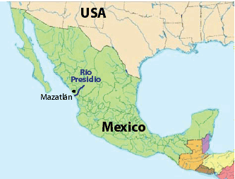
RÍO PRESIDIO: Mexico's Second Deepest Canyon |
| 110 km (70 miles); class IV, 6 days |
| Aug-Sep: rendezvous in Mazatlán. RESERVE NOW |
Join a kayak/raft expedition on Río Presidio starting at a remote road access point just past several unrunnable chasms. We will face numerous class IV rapids through the second deepest canyon in North America, including in the initial 14 km of virgin river never paddled before!! Use your boat or ours. We welcome anyone: kayakers, rafters, and raft passengers/paddlers. Another 3 days of class IV may be available afterward (Río Baluarte).
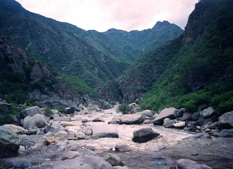
Río Presidio is a whitewater river gem flowing from remote areas in the heart of the Sierra Madre Occidental into Sinaloa. It passes through the second deepest canyon in North America and eventually debouches into the Pacific just south of Mazatlán. Aside from the spectacular scenery and side-canyon hiking possibilities, this trip should be very appealing to the whitewater enthusiast due to numerous class IV rapids and the potential for adding some class IV-V paddling at the start. Our descent will begin below the unrunnable chasms that were tackled by Stookesberry and crew in 2010 (read a little blurb and see a teaser video clip). They took out where we will put in.The first 14 km of our journey is almost certainly a first descent. It appears to contain numerous class IV rapids that are open and not obstructed with boulders, but with a gradient of 15 m/km (80 fpm), the potential exists for one or two of them to have class V holes/hydraulics. Compared to the neighboring Piaxtla, the Presidio trip has tougher whitewater, fewer calm days, and is more remote - we will not pass any towns on our journey (only a few houses at a place called "El Palmarito"). Unfortunately, the lower part of this free-flowing river was drowned by Presa Los Picachos in 2009. We still can enjoy the main whitewater-filled section of the river and take out at the head of the reservoir.
TENTATIVE ITINERARY:
Day 0: rendezvous with participants in Mazatlán
DAY 1: drive to put-in (~8 hr; 4WD): 760 m elevation
DAY 2; rig; recon section above the put-in; class IV-V; 5 km
DAY 3; first descent class IV rapids; explore side canyons; ~15 km
DAY 4; main Presidio canyon; one potential P; class IV; ~30 km
DAY 5; class III-IV; beautiful canyon; ~35 km
DAY 6; class II; arrive at take-out by reservoir ~15 km
DAY 1: Most of our first day will be spent driving up into the mountains and then descending a dirt road to the river. The scenery should be amazing. We will camp by the river.
DAY 2: We will rig the boats and explore the upper sections of the river, hiking upstream on a trail from where we camped the previous night to a point about 6 km upstream where an interesting side canyon enters. Both the side canyon and a bedrock waterfall in the river should be enough to warrant the hike, but as an added benefit, if you carried your boat up, you'll be able to enjoy the class IV-V rapids getting back to camp. We will load up the rafts at that point and head a few kilometers downstream into the virgin 14 km section, tackling the first big rapid on the run.
DAY 3: Very soon after launching, we will face a number of difficult class IV rapids and decide what they should be called. [In 2010, Ben Stookesberry, Rafa Ortiz and crew took out at our put-in spot. On Rocky's pioneering first descent in 2000, the put-in road did not exist, so he hiked into Palmarito.] We will only cover about 15 km this day due to frequent scouting of the difficult rapids, a potential portage, and the presence of two other side canyons that look interesting to explore. We will pass El Palmarito and set camp downstream where the river enters more isolated canyon.
DAYS 4: Soon we will descend into a boulder-strewn section and face "Cascada Exageración" the toughest rapid in this section that was rated easy class V by Rocky on the first descent. It may merit a portage. We will attempt to make our 4th camp still within the more narrow confines of the main canyon. On Day 5 we will
DAYS 6-7: On DAY 6 we emerge from section where the river is narrowly confined and will cruise on class II-III water to a nice sandy camp. On Day 7, we will arrive at the backwaters of Presa Los Picachos, a reservoir completed in 2009 and now flooding its maximal amount at 80 m high. A short paddle across the initial parts of the reservoir should land us at a take-out road where we will meet our shuttle drivers and head back to Mazatlán.
NOTE: Although Rocky did this trip in 2000 (paddling all the way to Mazatlán), he started at Palmarito and does not have many good photos of the trip. He recalls it as one of the best class IV journeys in the Sierra Madre and suitable for rafts. Part of the point of the trip is to get better photos and video of the river, explore the upper section around the put-in road, and hash out the current logistical details.
.
COST
This trip is being run to increase appreciation of the river and foment opposition to the planned dams. We welcome everyone: raft passengers, raft paddlers, raft rowers, kayakers, IKers, and guides. No prior rafting experience is required to join a trip. We offer professional level service similar to other established outfitters. The general costs of this and other trips is listed at: COSTS
Special discounts are sometimes offered to folks on our email list, so you are encouraged to sign up (Email List info).
RESERVATIONS
If interested in joining a trip, start a discussion by sending a note stating how you found out about the trip and a little background info about you and your paddling experience, what dates might work for you, and what sections of the expedition you are most interested in joining. Once you get the go-ahead, you will need to provide a deposit to reserve your place on the trip. The balance must be received prior to trip commencement. See PAYMENTS for payment options.
TRANSPORTATION
We will have a vehicle to pick you up in Mazatlán and transport you to the river and back. Depending on the number of paying participants, this vehicle might be a large pickup (5-person capacity), Suburban (7- or 9-person capacity), or combination of the two. We plan to charter a flight from San Ignacio up to Tayoltita or a point on the rim and make our way back to San Ignacio and then all the way to the ocean. The planes can handle 6 passengers each.
SAFETY / HEALTH
(click here)
FOOD/ALCOHOL/WATER
(click here)
CHORES, TOILET AND BATHING
(click here)
WHAT TO PACK
(click here)
SAFETY
The violence in Mexico surrounding the drug was has been in the news a lot in the past three years. The violence is confined to drug traffickers (narcos) and those associated with them, including law enforcement. In addition, the river we will be journeying down did not have any marijuana cultivation visible near it, and we are likely to encounter few residents. Locals from Sahuaripa will accompany us to the put-in and from the take-out, facilitating positive interactions. We may even have one such person in guide training on the raft. As such, we are not likely to be harassed or molested in any way related to the drug war. For further discussion of the drug war and safety concerns, click here.
Independent of the drug war, there has always been potential danger for assault in Mexico by armed bandits (bandidos). This is not different now as it was 5 years ago or 10 years ago or 20 years ago. Such risk is common in any third world country where citizens are very poor. In the event of assault, we will do all we can to protect our clients and ourselves, but may have to sacrifice our possessions. Since we can never guarantee against such assault, you must agree not to hold us liable for consequent personal injury/damage/loss you sustain on this outing.
The other aspect of safety is prevention of accidents. It is of utmost importance that you take all precautions necessary to avert injury, sickness, and complications while on the trip. As guides, we are there to help get you safely to the river, down it, and back out, but cannot guarantee against accidents. You must accept the responsibility for what happens on the river if you are in control of your craft. If you are concerned about the whitewater or other aspects, it is your responsibility to make appropriate decisions whether to run the rapid or not and to stay close to someone who can watch and oversee you (if you desire that level of protection). If an accident occurs, we will do all in our power to help you, see that proper care is rendered, or evacuate you if need be. Rocky was trained as a Wilderness First Responder and can administer appropriate emergency medical care if needed. We will have two basic first aid kits available. We will also carry a satellite phone for emergencies and changes of plan.
WATER LEVELS
We have timed this trip to coincide with highest probability of encountering good river flows in the Presidio. In September, flows average ~100 cms (3500 cfs) at Siquieros. Water levels can fluctuate rapidly due to spotty intense thunderstorms that are characteristic of the monsoon season in the region. At low water the river may not seem as difficult. At high water, the water moves faster and big hydraulics develop. It is important that rafts be tied up well so they don’t drift away in a rising tide on the river. Equally important, the camp must be set at a high enough location so it will not be flooded. We may encounter rapidly rising river that reaches camp (usually in the evening). If this happens and you are the first to notice, please wake the guides first, and we will assess the situation. It may be necessary to move camp higher.
NOTE:There are several take-out opportunities between 56-80 km after the upper La Petaca put-in at the Las Habitas Diversion Dam. Our trip may be as short as 56 km. Also, with enough expert clients, there may be an option for class V kayakers to run the section above our put-in on the first day and meet us at our camp (this would be the lower Río Los Laureles