|
RÍO GRANDE-COLORADO: Best Expedition in Argentina! |
|
310 km (192 miles), class III-IV (P), 12-14 days (half-trip possible) |
| launches: Jan22 Dec4 Dec21 (2024) Jan8 RESERVE |
| OTHER TRIPS |
Río Grande-Colorado offers the best expedition river trip in all of Chile and Argentina, passing through beautiful higher elevation Andes canyon and the Reserva La Payunia with its eerie lunar volcanic landscape. We'll paddle through plenty of fun class III and IV rapids, spend nights on fine beach camps, feel the wind blow us downstream, and finish on Río Colorado at the northern border of Patagonia as we also explore hot springs, side canyons, waterfalls, and volcanic craters. Each participant will see what will be lost with a series of planned dams that will drown most of the upper river. Help us Save Río Grande-Colorado. [Nearby trip: Río Neuquén.]
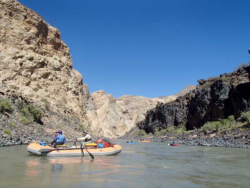
Río Grande-Colorado begins its raftable stream about 70km upstream of the highway connecting Bardas Blancas (Argentina) to Talca (Chile). The river is fed by springs and snow accumulated from winter storms and melted during the warm spring season. Being the northernmost boundary of Patagonia and on the dry east side of the Andes, sunny weather and warm temperatures are the norm in late spring and summer. The first 6 days of this expedition will have class III and IV as we progress down to and through the Portazuelo del Viento where the largest dam is to be built. After a flat open section of ~60 km, we get to the unraftable La Pasarela basalt gorge (portage with vehicle help), followed by 2 days of incredible whiewater and then a more remote ~5-day wilderness class III canyon section by the eerie volcanic Payunia Reserve. The reserve is currently under consideration as a UNESCO World Natural Heritage Site due to its unique concentration of volcanic cones/craters and flora/fauna, and the Argentinian government is seeking to expand the protected area. Some trips may continue an additional 3-4 days on Río Colorado (class II) down past Rincón de los Sauces through the final beautiful basalt canyon of the river to the town of 25deMayo. For a slideshow with captions, see PHOTOS. For a video, see VIDEO(drone).
Join us for a raft/kayak descent of this river and experience one of the last remaining raftable whitewater rivers that remains undammed in Argentina. See the scenery change as you descend from nearly 2000 m elevation down through eerie Mars-like basalt lava desert canyons of La Payunia reserve. Navigate challenging rapids and see the nature of the Cuyo and Patagonia. Help us in our mission to publicize this river's wonderful canyon to keep the river free-flowing without the dams that have been proposed (and one already approved for construction). Read more about this issue and sign a petition at: PETITION.
You might also consider joining a similar raft/kayak descent on the fine rafting river just to south: Río Neuquén.
GRANDE-COLORADO SECTIONS:
The Río Grande-Colorado can be divided into five sections: Upper Grande, Bardas Valley, Wilderness (Volcanic) Grande, Main Colorado and Lower Colorado. Most trips will cover the first four sections while others may cover all five sections or shorter parts. The Upper Grande is the most threatened with a series of 5 dams (the Portezuelo del Viento complex), whose construction was approved in Jan2018. The Wilderness Grande is the section that flows through the Payunia Reserve and is the most remote. The river has many access points possible aside from the Wilderness Grande section.
| section | km | days | class | elevation | m/km | fpm | note |
| UpperGrande | 120 | 5-6 | III-IV | 2120-1420 m | 5.8 | 32 | fun whitewater; great hikes/scenery; road access lower parts |
| BardasValley | 60 | 1-2 | II | 1420-1225 m | 3.3 | 18 | easy desert valley section ending with volcanic lava flow on RL |
| WildernessGrande | 118 | 4-6 | III-IV | 1225-785 m | 3.7 | 20 | remote canyon; great hikes/scenery; Payunia Reserve; one V; one P |
| Main Colorado | 87 | 2 | II | 785-585 m | 2.3 | 13 | desert to Rincón de los Sauces; downstream winds; nice crater hike |
| Lower Colorado | 140 | 2-3 | II-III | 585-350 m | 1.7 | 9 | beautiful basalt canyon; downstream winds; to 25 De Mayo |
PRIOR DESCENTS:
Several Argentinian kayakers descended the ~30 km section betwen La Pasarela (P) and El Zampal (class V). There were no reported descents of the rest of the long remote Wilderness Grande or Upper Grande sections by 2015. Rocky Contos and Tomás Binimelis paddled much of the section in Oct2015. In Dec2016, Rocky led the first full raft expedition group through the first four sections of the river (SierraRios trip). Additional SierraRios expeditions were completed Dec2017. Dec2018, and Jan2019. The Lower Colorado has been descended by numerous individuals at times due to its easy nature and frequent access/proximity to Rincón de los Sauces and Veinticinco de Mayo.
Personality/Experience/Leadership:
Participants need no prior rafting experience as a raft passenger/paddler but everyone on the trip should be comfortable camping and have an easygoing attitude in order to get along with a diverse group on a multi-day trip for an extended period. All participants should be in good physical condition. We welcome competent boaters to paddle or row this river, but you need to have adequate and recent experience on comparably difficult rivers. If you are in charge of your own kayak or raft, you are responsible for what happens to you on the water and for the equipment you use. Every participant must sign a liability waiver.
Everyone joining SierraRios trips should have an interest in river conservation and help us on our mission to document the river further, talk to residents, and publicize the planned dams. You should plan to help facilitate the trip in any way possible, including transport of some gear down to the destination if necessary. You don't need to be bilingual but it is helpful and more fulfilling to communicate with local residents when we meet them.
The trip leader will have main authority when it comes to decisions for the group regarding river progress, camp, and other decisions affecting the group. If a participant has overestimated their ability to row or kayak, he/she may be mandated to ride on a raft, sit out days, and/or be assessed other penalties and in severely incompetent situations, not allowed on the multi-day part of the trip. Trip leader decisions can be vetoed by a majority vote of the group. Any participant always has the right to leave the trip if they so desire but refunds are at the discretion of the owners.
DAMS and PETITION:
The Grande in Argentina has a series of 5 dams planned on the upper river (upstream of Bardas Blancas) called the Portezuelo del Viento project. The lowermost dam would be the largest and is designed to generate hydroelectricity and also divert ~35 m3/s of the river into the neighboring Atuel drainage (going down to San Rafael) where it can generate power through two more powerplants and provide more irrigation water to the area's farms. We encourage everyone to sign a PETITION stating that you do not support this project. The project is contentious, and government leaders need to hear that there is growing support to keep the river free-flowing for recreational and environmental use.
UPDATE: The project was approved in early 2018 by the federal government and Mendoza government despite strong opposition from the people of the province of La Pampa, who will lose a lot of water in the Colorado that they rely on for irrigation. As of Jan2021, construction has not started and the project may not be started for another year or two.
https://es.wikipedia.org/wiki/Proyecto_hidroeléctrico_Portezuelo_del_Viento
http://www.laarena.com.ar/avances/mendoza-confirmo-intencion-de-avanzar-con-portezuelo-y-potasio-rio-colorado
http://www.losandes.com.ar/article/nueva-puja-por-portezuelo-del-viento
RENDEZVOUS POINTS/TRANSPORTATION
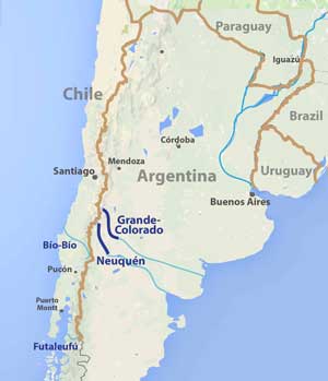
MENDOZA/SAN RAFAEL: Our main rendezvous will be San Rafael, located in Mendoza province. San Rafael is a 3 hr drive to the southeast of the city of Mendoza and also in the main wine country. San Rafael has ~200,000 people, while Mendoza has roughly 1.1 million people in its metro area. The city of Mendoza is the capital of the eponymous province, known for its robust red wine often made from Malbec varietal grapes. Tourists to Mendoza or San Rafael often spend at least one day visiting wineries or other sites in the area (the Río Atuel is a popular day excursion close to San Rafael). Mendoza has an airport with service to Buenos Aires and Santiago, while San Rafael has service to Buenos Aires only. Other paddling opportunities in the area exist on Río Mendoza (IV), Tunuyan (III and IV), Diamante (V), Atuel (II or IV), and the Vavarco-Neuquén (II to V).
Air travel: The best airports to fly into are Mendoza (MDZ) or San Rafael (AFA). Try using a general search engine such as www.google/flights or www.kayak.com to find flights. Sometimes it can be cheaper to book a flight to one of the major airports nearby - either Santiago Chile (SCL) or Buenos Aires (BUE or EZE) and then getting to San Rafael via local flight or bus. The Santiago-Mendoza flight is often very inexpensive (see SkyAirlines), while domestic flights from BUE-AFA or BUE-MDZ are more costly (see AerolineasArgentinas). Alternatively, a less costly but longer option is to take a bus from Santiago to Mendoza (7-8 hr; ~$25USD) or from Buenos Aires to Mendoza or San Rafael (14hr-16hr; ~$60USD).
TENTATIVE ITINERARY:
Grande-Colorado; 14 days
Day0 rendezvous in SanRafael; meet participants; Hotel Complejo Mi Sueño
Day1 to Grande put-in (270km paved + 70km dirt; 5hr); start rigging; car camp
Day2 Upper Grande: hike in Valle Hermoso; rig and launch; into Cajón Grande; km 0-15; 15 km class III-IV
Day3 Upper Grande: through Cajón's toughest rapids (IV); km 30-55; 25 km class IV
Day4 Upper Grande: gorgeous scenery and continuous II-III; camp Portazuelo del Viento; km 55-85; 30 km class III-IV
Day5 Upper Grande: hike to cerro Portazuelo del Viento; to Bardas Blancas camp km 85-121; 36 km class III
Day6 Bardas Valley: optional excursion to Cueva La Bruja or paddle Bardas Valley section; km 101-161; 60 km class II
Day7 Wilderness Grande: portage LaPasarela(P); camp in gorge section; hike; (km 162-172); 10 km class III(P)
Day8 Wilderness Grande; hike and enjoy volcanic gorge; km 172-191; 20 km class III-IV
Day9 Wilderness Grande; arrive to and walk passengers around Zampal (V); km 191-211; 20 km class III-IV(V)
Day10 Wilderness Grande; narrows hike at camp; km 211-241; 30 km class III;
Day11 Wilderness Grande; to past the Barrancas confluence; km 241-281; 40 km class II-III
Day12 Colorado; km 281-330; waterfall canyon hike; 49 km class II
Day13 Colorado; km 330-380; into more open terrain; possible take-out; 50 km class II
Day14 Colorado; km 380-410; Volcán Los Loros crater; to Rincón de los Sauces; dinosaurs; return San Rafael; 30 km class II
If the water levels are low (Feb-Mar), trips may only cover a total of ~310 km to El Portón and have the portage of La Pasarela on Day 8. Other trips may be converted to Río Neuquén depending on flow and group.
Expected Progress:
We will generally paddle from ~9 am to 4 pm with some stops for side excursions. At normal higher spring season flows (Oct-Dec) the river is very fast so it is usually quite easy to cover 10 km/hr of class III water even in rafts as long as we are on the water focusing on downstream progress. Stops for hikes, scouts, flips, and water collection do cause signficant delays, but we should still easily cover the full distance in the allotted time if flows are average and we do not have unplanned delays. With average flows there should be plenty of time in camp. If flows are abnormally low, there may be less time for such activities. With extra time, we may arrange additional excursions.
Maps:
If you have provided a deposit for the trip, you can access printable maps of the river with appropriate pass codes. Topo maps span the entire river with roads, rapids, features and potential beach camps marked. Otherwise, if you would like access to the maps, you can sign up as a member of SierraRios specifying you're interest in Argentina.
COST
This trip is being run because it is one of the most incredible in the world and more paddler visitation is needed to help raise awareness. More ecotourism income to the region and appreciation of the natural resource will help stop the river's destruction with dams. Our general pricing guidelines are found at the following link: Contribution guidelines: General
Special discounts are sometimes offered to folks on our email list, so you are encouraged to sign up (Email List info).
RESERVATIONS
To join a trip, email a note of your interest (email to reservations@sierrarios.org), and make a deposit to reserve your place on the trip ($500). Full contribution must be received before the trip. See PAYMENTS for payment options and cancellation policy. Trips may be cancelled 3 months before launch if there is not enough interest (6+ paying participants will assure a trip occurs).
GUIDES (may include the following):
(1) Rocky Contos, kayaked the Upper Neuquén and Grande-Colorado in Oct 2015 and led the first group rafting trips on these rivers in Dec2016 and will be leading trips in Dec2018. Rocky has been certified in swiftwater rescue (SRT-PRO) and is a wilderness first responder (WFR). He also has an incredible CV of first descents and leading large group trips. Rocky founded SierraRios with the goal of conserving the rivers of Latin America, and hopes that increased awareness and enjoyment of the resource will lead to protection. He is organizing all aspects of the trip. He likely will be kayaking but may row a raft.
(2) Luciano Lázaro is our main Argentinian guide who will guide or co-guide most trips. Luciano lives in San Rafael and is a river guide on the Atuel typically and has guided several seasons on the Futaleufu. He has certifications in swiftwater rescue and first aid and helped guide the first full raft descent of the river Dec2016 and led the trip in Dec2017.
(3) Other guides/trip leaders are to be decided, but likely will be selected from other SierraRios and Argentinian/Peruvian/Chilean guides: Ariel Diaz, Antonella Urbina, Tomás Binimelis, and Pedro Peña.
BUGS / UV / SILT / WIND: UV rays from the sun can be intense so it is recommended that you use sunblock liberally. On the middle and lower elevation areas in late spring into summer, sometimes we encounter a lot of tábanos (deer flies) that are generally easy to swat but can get the better of you causing a temporary painful bite. It is best to cover up and liberally apply repellent where they may be present. During spring and summer there is often a strong wind blowing from west to east (coming down the Andes from Chile) that will often be a downstream wind as these rivers head in a southeast general direction. However, in some river sections where it flows due south, this can be a cross-breeze making naviation a bit more difficult. We generally select camps that have protection from the wind. Winds tend to be strongest in the Portazuelo del Viento to La Pasarela section of the Grande, and in the Andcollo-to-ChosMalal section of the Neuquén. The rivers are often flowing with clearish water when low but when high (Nov-Dec) often will contain some silt. However, there is little habitation in the drainages, meaning the water is relatively free of pollutants and little trash is found along the sides and in eddies.
The trip occurs at temperate austral latitudes starting in relatively arid country at moderate elevation and ending at lower elevation full Patagonian desert. The weather is usually sunny and warm - phenomenally nicer than the cool, rainy summer weather of the Futaleufú -= and much sunnier/warmer than the even the weather along the Bío Bío. Average temperatures and/or river flows for several locations are presented below. Trips are generally scheduled Nov-Feb which is the spring to summer dry season with warm temperatures. Although it can be cool in October and even November, from Nov-Jan it will generally be hot in the day and cool at night. The water in the river is often cold (10oC often at the start but warming to 20-23oC by the end) so usually a drytop will make kayaking more comfortable during bigger rapid days on the upper sections, and a paddle jacket and pants will make rafting more comfortable. As one progresses to lower elevations, the temperatures increase. Winds can be strong at times, but the prevailing direction is to the east so they will often be blowing downstream.
Water in Ríos Grande-Colorado and Neuquén in spring to early summer comes mostly from snowmelt but also from springs. The snowpack in the region is a good predictor of general flow levels through the main season. The 2011-2017 spring seasons have had lower than average flows, and sometimes very low such as spring 2016. Flows during the spring snowmelt period fluctuate with temperatures as well as with the occasional rains. Warm temperatures, long days, and high flows are desirable on these expedition trips, prompting our trips to generally be scheduled November to February, but launches in October and March are also possible.
| Station | Ene | Feb | Mar | Abr | May | Jun | Jul | Ago | Sep | Oct | Nov | Dic | - | Avg | |
| ChosMalal (974m) | temp(C) | 31 | 30 | 27 | 22 | 17 | 13 | 13 | 15 | 18 | 23 | 27 | 29 | - | 72 |
| temp(C) | 12 | 11 | 8 | 5 | 3 | 1 | 1 | 1 | 3 | 6 | 9 | 11 | - | 56 | |
| precip(mm) | 10 | 10 | 11 | 17 | 42 | 36 | 32 | 30 | 15 | 13 | 10 | 9 | - | 237 | |
| ---------------------------- | -------- | -------- | -------- | -------- | -------- | -------- | -------- | -------- | -------- | -------- | -------- | -------- | -------- | - | -------- |
| temp(F) | 88 | 87 | 81 | 72 | 63 | 56 | 55 | 59 | 65 | 73 | 80 | 85 | - | 72 | |
| temp(F) | 54 | 52 | 47 | 41 | 38 | 34 | 33 | 34 | 37 | 42 | 48 | 51 | - | 56 | |
| precip(in) | 0.4 | 0.4 | 0.4 | 0.7 | 1.7 | 1.4 | 1.3 | 1.2 | 0.6 | 0.5 | 0.4 | 0.4 | - | 9.1 | |
| ---------------------------- | ----- | -------- | -------- | -------- | -------- | -------- | -------- | -------- | -------- | -------- | -------- | -------- | -------- | - | -------- |
| Grande (BardasBl.) | cms | 169 | 100 | 67 | 54 | 55 | 57 | 54 | 55 | 66 | 123 | 222 | 249 | - | 108 |
| cfs | 6000 | 3500 | 2400 | 1900 | 1900 | 2000 | 1900 | 1900 | 2300 | 4400 | 7900 | 8800 | - | 3800 | |
| ---------------------------- | ----- | -------- | -------- | -------- | -------- | -------- | -------- | -------- | -------- | -------- | -------- | -------- | -------- | - | -------- |
| Colorado (ButaRanquil) | cms | 231 | 140 | 96 | 78 | 81 | 83 | 77 | 79 | 89 | 159 | 294 | 318 | - | 144 |
| cfs | 8200 | 5000 | 3400 | 2700 | 2800 | 2900 | 2700 | 2800 | 3200 | 5600 | 10400 | 11300 | - | 5100 | |
BOATS AVAILABLE IN ARGENTINA:
See boats available in Argentina. We will be augmenting the fleet later this year with more kayaks and rafts.
A FEW COMMENTS FROM PAST PARTICIPANTS:
"The Río Grande had all the elements of a great multi-day trip and then some. I loved starting high up in the Andes floating through braided alpine channels, then descending into steep walled canyons, and finally the surreal lava canyons near the end. The whitewater was exciting, side hiking spectacular and the Argentinian guides kept everyone in good spirits. I would strongly recommend this trip to people who looking for a off-the-beaten path river. The Río Grande joins the slew of other rivers facing imminent threat from dams. I of course am strongly opposed to most dams as they irreversibly damage the ecosystem and bring with them many other negative effects. Too often the energy companies sell it as ‘clean’ energy, but they don’t tell the other side- the side that treasures will be lost, habitat destroyed, homes flooded, and so on. I hope that more Argentinians can see what a magnificent place this is before they consider damming it for energy and losing a part of their natural heritage."
Sam Morrison; Participant on Dec15 (2016) Grande-Colorado expedition
"It’s a world class trip in five star scenery."
Eva Appenzeller; Participant on Dec23 (2017) Grande-Colorado expedition
"Without doubt the trip was great, from the landscape to the whitewater to the nature makes the trip is a life time experience for all the participants."
Roberto Rodas; Helper guide on Dec23 (2017) Grande-Colorado expedition
"I thought the difficulty ratings were on par with how we rate rivers here in the PNW. Given that the portages were relatively straightforward around the bigger class IV drops, this trip would probably be comfortable for Class III kayakers or IK’ers. Side hikes were great and indeed, we may have gotten in another one or two if the group chose to rally... Generally speaking, the camps were pretty decent... I was impressed with the logistics and with the timely arrival of El Senor (the goat rancher), with his truck and helping hands on the mandatory portage. Food was well done and tasty. I felt completely safe and that we exercised good safety practices... I think Argentinians (at least where I went) were some of the warmest and friendliest people I’ve ever encountered. ."
Ken Bender; Participant on Dec15 (2018) Grande-Colorado expedition
"Preparation, logistics, and gear were great. The food was amazing and the chefs very top notch...Safety and sanitation were also well handled... There was a phenomenal amount of bird life on the river... Both ‘Lucho’and ‘Pedrito’ were great guides and complimented each other very well. Pedrito is highly organised and very good with a wide range of personalities. Lucho is much more low key but holds lots of knowledge when asked. He made an amazing Asado and picked great spots to stop and engage with locals both going to the river and coming back.
Michael Wilkes; Participant on Jan6 (2019) Grande-Colorado expedition