|
BLUE NILE: The Grand Canyon of the Nile (Last Descents!) |
|
up to 793 km (492 miles), class III-IV(V), 12-14 days each Upper/Lower) |
| launches: Oct20U Nov4L [2024] RESERVE |
| OTHER TRIPS |
The Blue Nile in Ethiopia passes through the bona fide Grand Canyon of Africa as it descends from Lake Tana to the desert in Sudan enroute to Egypt. Join our raft/kayak group as we paddle through the length of the canyon in Ethiopia with challenging rapids, cool side hikes, beautiful beach camps, and interesting geology, people and wildlife. In 2018, you will be one of the last people to float through the Western Cataracts and Lower Gorge sections before they are drowned by the Grand Ethiopian Rennaissance Dam. Help us SAVE THE REMAINING GRAND CANYON OF THE NILE!
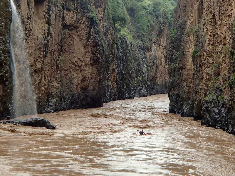
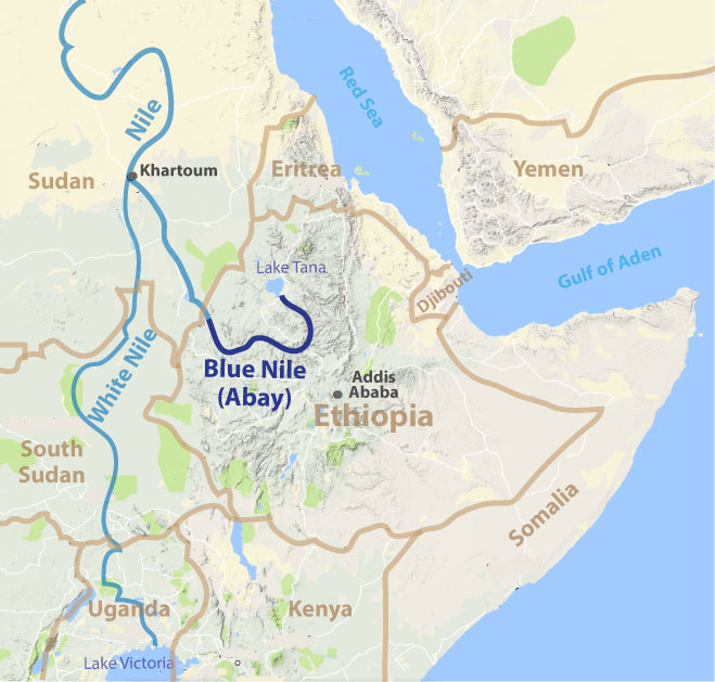
The Blue Nile (Abay) is one most incredible rivers in the world and the source of most of the water for the Nile in Egypt. On these expeditions, we’ll be rafting down the river in Ethiopia where it has carved the bona fide Grand Canyon of Africa. Our main "Grand Canyon Nile" trips are appropriate for anyone. No prior whitewater experience is necessary on a raft, and anyone can remain safe from crocs and hippos on these large boats. Although the Grand Ethiopian Rennaissance Dam (GERD) started flooding in 2020, the extent of the reservoir when full will only flood the lowermost 220 km of river (up to 50 km of the Western Cataracts) which likely will occur in 2026. Even then, most of the Grand Canyon of the Nile will remain free-flowing (696 km of the original 916 km or 76%; similar to what remains of the Colorado's Grand Canyon with flooding by Hoover Dam). On the Blue Nile, we have three options for trips:
Bashilo-Blue Nile (class III; ~20 days; 763 km),
Upper Blue Nile (class IV-V; ~14 days; 331 km)
Lower Blue Nile (class III-IV; ~12 days; 462 km)
Sign up as an individual or group on any general trip. Or as a private group, we may be able to schedule special trips - either as a fully guided trip or a Outfitting Service trip for experienced boaters.
EMAIL LIST: Sign up for our email list (send an email) and you'll be advised of upcoming trips and often special lower rates compared to the general TRIP COST.
| MORE INFO: | |
| OVERVIEW MAP (of Blue Nile drainage) | |
| TOPO MAPS (of river) | |
| Ethiopia Info | |
| BoatsAvailable_Ethiopia | |
| BELES RIVER video (first descent) |
TRIP OPTIONS
We generally offer three options for trips: Bashilo-Blue Nile (~20 days), Upper Blue Nile (~14 days), and Lower Blue Nile (12-14 days), described below:
BASHILO-BLUE NILE + LOWER BLUE NILE (class III; 18-20 days total; 886 km) trips are scheduled only at higher water (mid-July though late-September launches) and are based out of Addis Ababa. The initial part of the expedition is on the class III Bashilo River which joins the Blue Nile in the Gorgeous Gorge. It is an alternate high water option to the Upper Blue Nile trip and covers most of the same section except for the class IV-V TisAbay and Northern Gorge sections, and still allows participants to go through the deepest and most beautiful part of the Grand Canyon Nile. High water allows much faster progress.(usually 12-16 km/hr). After rafting 142 km through the Bashilo's Gorgeous Canyon (see Photos2019 trip), the trip continues through 159 km of the Blue Nile through its GorgeousGorge and InnerCanyon to the Rennaissance Bridge where we generally have resupply food and ice delivered. All Bashilo-BlueNile trips continue through the Lower Blue Nile section (Black Gorge and Western Cataracts- also see Photos2019), covering that section in 7-9 days (high water).
launches: Sep5 (Bashilo)
UPPER BLUE NILE (III-IV with several Vs; 331 km; ~14 days at medium levels) trips cover the initial 331 km of the Blue Nile (TisAbay, NorthernGorge, GorgeousGorge, and InnerCanyon). Launches are only scheduled at medium water levels from mid-September through mid-November (when safe and not too low). Trips are based in Bahir Dar and start with a flight from Addis Ababa to Bahir Dar and a hotel, then an initial excursion on Lake Tana and another day to visit Tissisat Falls (or kayak the Tis Abay section) before starting on the general raft-support trip through remote areas. With rafts, we pass through the challenging class IV-V Northern Gorge (the class Vs are generally walked by participants), followed by the easier Gorgeous Gorge and Inner Canyon (class II-III). Usually 2 layover days are planned on the trip, including one at the Gauntlet when we spend the day ghost-boating the rafts through a difficult and dangerous class V+ gorge, and another in the Gorgeous Gorge. We also usually spend a full day just getting through Blackwall Cavern rapid. At the end point (Rennaissance Bridge), we do a major food resupply usually by driving back to Addis Ababa for a layover day in hotels before continuing on the Lower trip. Participants continuing on the Lower Blue Nile can go to Addis Ababa for a hotel or stay at the camp for the layover day. The expedition then continues with the Lower trip.
launches: Sep28, Oct31 (2023)
LOWER BLUE NILE (III-IV; 462 km; 12-13 days at medium levels) trips are scheduled any time of the year (and always after Upper Blue Nile trips and as part of Bashilo-Blue Nile trips), starting at Rennaissance Bridge and continuing to Sirba at the end of the Western Cataracts. The group passes through the class III-IV Black Gorge and then the class II-III Western Cataracts (trips used to pass the Lower Gorge but this section is flooded as of 2022, so trips will end at Sirba). These trips can be safely and comfortably done both at high water and low water [the river never gets too low in the dry season (Dec-May)], but time to complete the trip varies based on water level: at high water, trips are completed in 8-10 days; at medium levels 11-13 days; and at low levels ~14 days. Not all of this section is river with current because some of the section (including all of the Lower Gorge and within a few years, half of the Western Cataracts) has started to be flooded by the GERD in the 2020 season. All Lower Blue Nile trips starting in 2023 will stop at the end of the Western Cataracts due to the Lower Gorge section flooding behind the GERD. Starting in 2023, the lower part of the Western Cataracts section will end in the reservoir created by the Grand Ethiopian Rennaissance Dam (GERD) with 10-20 km of slackwater to get through in 2023, ~30 km of slackwater in 2024, ~40 km of slackwater in 2025 and up to 51 km of slackwater starting in 2026. Thus, starting in 2023, we plan to have a motorboat arrive and tow our rafts across the slackwater to Sirba.
launches: Oct13, Nov14 (2023)
A full Grand Canyon Nile expedtion (Upper + Lower) used to cover 916 km (568 miles), but starting in 2023 will only cover 737 km. We always have resupply and possible passenger exchanges at Rennaissance Bridge - and sometimes at Mota/2ndPortugueseBridge (end of Northern Gorge) and Bure Bridge (end of Black Gorge). To get a better idea of all the sections, see the Overview Map and read about the individual sections below.
BLUE NILE SECTIONS:
The "Grand Canyon of the Nile" (coined by Snell's expedition in 1968) refers to the profound canyon section of Blue Nile in Ethiopia where it cuts a canyon through a high raised tableland. The canyon extends >800 km from Tissisat Falls to near the Sudan border and is generally 1200-2000 m (4000-6600 ft) deep on both sides throughout its length. Although there are similarities to the Colorado's Grand Canyon, the Nile's Grand Canyon has less limestone and consequently fewer vertical walls. Access points divide the river into various sections called TisAbay, Northern Gorge, Gorgeous Gorge, Inner Canyon, Black Gorge, Western Cataracts, and Lower Gorge sections. Each section has numerous rapids and other features/side excursions/villager contacts. Aside from the TisAbay and Northern Gorge (with many class IVs and several class Vs) and Black Gorge (with several class IVs), most of the river is class II and III in difficulty and comparable to the difficulty of the Grand Canyon of the Colorado. A full Blue Nile expedtion (Upper + Lower) covers 916 km (568 miles) and passes various access points, but we generally only have passenger exchanges at Rennaissance Bridge. To get a better idea of all the sections, see the Overview Map. The access points are:
2nd Portuguese Bridge (km90): involves a hike of ~10 km from near Jaragedo
Merto Bridge (km220): ~9 hr drive from Addis Ababa
Rennaissance Bridge (km 331): ~6 hr drive from Addis Ababa
Bure Bridge (km 524): ~10 hr drive from Addis Ababa
Sirba Abay (km 800): ~18 hr drive from Addis Ababa
| section | km | days | class | rapids | scenery | hikes | cultural | note | |
| Gilgel Abay | 200 | ~5 | IV-V | +++++ | ++++ | ++ | ++++ | section from source to Lake Tana | |
| Lake Tana | 50 | ~2 | 0 | + | ++ | ++ | ++++ | monasteries on the islands of the lake | |
| ------------ | -- | -- | ------ | ------ | ------ | ------ | ------ | ------ | |
| TisAbay section | 40 | ~2 | IV(V) | +++++ | ++ | + | ++ | exiting Lake Tana but often little water now | |
| Northern Gorge | 50 | ~5 | V | +++++ | +++++ | ++++ | ++ | very difficult; class Vs at Gauntlet, Cave, BadSeeds | |
| Gorgeous Gorge | 130 | ~4 | III | +++ | +++++ | +++++ | +++ | incredible scenery and side canyons | |
| Inner Canyon | 111 | ~3 | II-III | ++ | +++ | +++ | +++ | nice scenery; more wildlife | |
| Black Gorge | 195 | ~6 | III-IV | ++++ | ++++ | ++ | + | fun rapids; hotter; remote with wildlife; crocs | |
| Western Cataracts | 267 | ~6 | II-III | +++ | +++ | ++ | +++++ | Gumuz native tribes; remote jungle with wildlife | |
| Lower Gorge | 179 | ~4 | II-III | ++ | ++ | + | ++++ | hot; some rapids; soon to be flooded by GERD | |
| Sudan | 756 | 10+ | I-II | + | + | + | ++ | Roseries Dam; then flat, open & hot to Khartoum | |
| -------------------------- | -- | --- | --- | --- | --- | --- | --- | -------------------------- | |
| TOTAL | 1978 | ~45 | - | - | - | - | - | for entire Blue Nile descent source-to-Khartoum | |
| TOTAL nice rafting | 916 | ~30 | - | - | - | - | - | full Blue Nile descent |
Tis Abay section (Lake Tana outflow)
class IV (V)
40 km (24 miles); 1-2 days
Lake Tana (1790m) to Tissisat Falls (1640m)
3.5 m/km (20 ft/mile)
avg flow August: 80cms (2,600cfs); avg flow January: 40cms (1200cfs)
The Tis Abay section from Lake Tana to Tissisat has a number of class II, III, IV, and V rapids but is generally in open country with a wide riverbed and the river often divides into many channels with several options available. The first major rapid about 6 km downstream from the lake is called Jordi Falls (IV) followed a few km downstream by the steeper Arafami Falls (V). There are many more drops with multiple channels on the way to Tis Abay (Tisissat Falls). The flow out of the lake is controlled by a regulating dam. During the years 2001-2012, the river usually had a constant ~110 cms released into it (+tributary addition) to generate power at the Tis Abay powerhouse all year long. However, now due to the Tana-Beles hydro diversion project removing water from Lake Tana all year into the Beles River, this section gets only an average of ~30 cms - with levels dependent on overall lake levels. Nowadays, during much of the year, the upper part of the run will not have enough water to raft. The best time of year to likely find fun flows in the upper ~25 km is Sep-Nov when releases from the lake will lilkely be 30-70cms (1000-2300 cfs), while the lower ~15 km should have good flows Jul-Dec from a combination of outflow and tributaries entering. The section ends at Tisissat Falls, a ~40 m two-tiered drop and the iconic symbol of the Blue Nile. A dirt road leads to the powerhouse and falls from near the lake - and continues beyond it about 2 km, so it is easy to skip this section and put in downstream, avoiding a potentially boney section of river if there is inadequate release from the lake (it also avoides the portage of the falls and the difficult gorge just downstream). We generally start our raft trips just downstream of the falls by the Tul confluence.
See slideshow of BahirDar/LakeTana (late July2017)
See slideshow of Tis Abay section (late July 2017)
====================================================================================
Northern Gorge (Grand Canyon Nile)
class IV (V)
50 km (31 miles); ~6 days
Tissisat Falls base (1600m) to 2nd Portuguese bridge (1380m)
4.4 m/km (24 ft/mile)
avg flow August: 200cms (7,000cfs); avg flow January: 50cms (1700cfs)
The Northern Gorge section of the Grand Canyon of the Nile is the most feared section on the river due to a series of difficult class IV and V rapids and has some very challenging rapids that can be difficult to pass with rafts - THIS SECTION SHOULD ONLY BE DONE WITH RAFTS AND EXPERT GUIDES - BEST WHEN WATER IS LOW-MEDIUM. The section starts at the base of Tisissat Falls (road access) where electricity is often generated by diverting the water out of the river above the falls and into one or two powerhouses. However, since 2016, water from Lake Tana (about 70cms out of an average 116cms) is preferably diverted into the Tana-Beles hydroelectric project with a larger elevation drop. There is still a mimimum flow required to be released to go over Tisissat Falls for ecological and tourist purposes during the daytime - this flow is highest in the traditional high water months of Sep-Oct-Nov. Aside from the water entering the Northern Gorge from Lake Tana, there are a number of tributaries that augment the flow appreciably during the rainy season, but provide little extra flow during the dry season. The rapids in the Northern Gorge start in a narrow gorge just downstream of Tissisat Falls with some class IV rapids leading down to the First Portuguese bridge (Alata bridge). We generally start with rafts at a point downstream of the bridge near the Tul confluence. From Tul confluence down to the Abaya confluence there are numerous difficult passages, the toughest of which are Zemocha (III-IV), Catfish Falls (IV), Gauntlet (V), Fich (III-IV), Crux (IV), Blackwall Cavern (V+), ZigZag (III-IV), and Bad Seeds (V), with many other IIIs in places. The toughest rapids end at the Abaya river confluence (entering RR and boosting the flow in the river substantially in the rainy season) with some fun class IIIs in the last kilometers down to the 2nd Portuguese bridge (a.k.a. Andabit bridge).
See slideshow of Northern Gorge (Aug 2017)
See slideshow of Northern Gorge (Oct 2017)
====================================================================================
Gorgeous Gorge (Grand Canyon Nile)
class II-III
130 km (81 miles); ~4 days
2nd Portuguese Bridge (1380m) to Merto Bridge (1200m)
1.4 m/km (8 ft/mile)
avg flow August: 1000cms (35,000cfs); avg flow January: 80cms (2700cfs)
The Gorgeous Gorge section of the Grand Canyon of the Nile is one of the most scenic sections of the river in a basalt gorge/canyon. The section starts at the 2nd Portuguese Bridge (Andabit Bridge or Broken Bridge) which was a pedestrian/mule bridge until it was partly destroyed by fleeing rebellious Ethiopians when they were being pursued by the Italians in the 1930s. Just after the turn of the millenium, the group Bridges to Prosperity repaired the bridge enough so it could be used by the local population to cross the river, but this repair had since fallen apart as well (current state of the bridge can change). Starting in 2020, a dirt road was completed arriving to the top of the gorge by the bridge, making access here easier (though a ~1 km hike is still required to get to the river). Downstream of the bridge, the Abay river moves swiftly among basalt cliffs (and some pillars) with frequent class II rapids (and a few IIIs). There are plenty of interesting side hikes on this section of the river - with perhaps the nicest scenery and most interesting natural features to explore along the entire river - including slot side canyons, natural arches, waterfalls, springs, and caves. One major tributary enters in this section: the Bashilo (RL), which during the rainy season generally will have 50-80% of the flow of the Blue Nile. The nights are still fairly cool at these elevations. Due to the interesting side excursions possible and easy floatability, this is a great section to spend some extra time and layovers. There are numerous inhabitants in the canyon here, but they tend to live in the higher elevations, coming down to the river to graze livestock, fish, or cross from Gojjam (west side) to Bejemder (east side)/Shoa (south side) or vice-versa. The section ends at the Merto Bridge (vehicle access possible).
See slideshow of Gorgeous Gorge (Aug 2017)
See slideshow of Gorgeous Gorge (Oct 2017)
===================================================================================
Inner Canyon (Grand Canyon Nile)
class II-III
111 km (69 miles); ~3 days
Merto Bridge (1200m) to Rennaissance Bridge (1030m)
1.5 m/km (8 ft/mile)
avg flow August: 1700cms (60,000cfs); avg flow January: 120cms (4000cfs)
The Inner Canyon section of the Grand Canyon of the Nile passes through the deepest part of the canyon and is next to the Gorgeous Gorge, is probably the next most scenic section of the river. The section starts at the Merto Bridge which was constructed in 2012 and is a ~1 hr drive from Merto Le Maryham (and ~10 hr from Addis Ababa). The river moves swiftly in a beautiful canyon with limestone, sandstone, and igneous basalt layers and frequent class II rapids. There are several interesting side hikes on this section of the river into side canyons and up to rims with grand vistas of the canyon. Two major tributaries enter in this section: the Walaka (RL) and Jemma (RL) rivers as well as a number of smaller tributaries on the right. There continue to be residents in the initial half of this section but not many in the lower half. The section ends at the Rennaissance Bridge (Shefartak Bridge), as part of the main highway between Addis Ababa and Bahir Dar (the two largest cities in Ethiopia). It is ~4 hr drive from Addis Ababa to this bridge. On our trips we often have a layover day at the bridge with most of the group going up to Addis Ababa for resupply and night in hotel with shower. This is the end point of the Upper Blue Nile trip, and the start of the Lower Blue Nile trip.
See slideshow of Inner Canyon (Aug 2017)
See slideshow of Inner Canyon (Oct 2017)
====================================================================================
Black Gorge (Grand Canyon Nile)
class III-IV
195 km (150 miles); ~6 days
Rennaissance Bridge (1030m) to Bure Bridge (800m)
0.9 m/km (4.8 ft/mile)
avg flow August: 2500cms (80,000cfs); avg flow January: 170cms (6000cfs)
The Black Gorge section of the Grand Canyon of the Nile is named due to the black rock on the sides of the gorge that extend much of the length of this section. Although this section has lower gradient compared to the Inner Canyon section, the river is much more voluminous and the rapids are tougher, especially at low flows when more features like waves and holes develop. The gorge starts after the Muger river enters (RL) and before the Guder river enters (RL). Near the start of the gorge is an interesting ruin called Castanio's Bridge (with the abutments still present from 1903, but the bridge and roads to it never were completed). Rapids get tougher after the Guder, with numerous class III rapids and several that can be class IVs. The class IVs that may be encountered include Rubin, Fincha-a, 200m Eddy, and Dumb. Most rapids are located where tributaries or gullies have deposited debris in the riverbed (similar to the Colorado in Grand Canyon). This section has few to no people living near the river and therefore you are more likely to encounter wildlife such as crocodiles, bushbuck, kudu, baboons, and hippos. It is important to take precautions against crocodile attacks (throw rocks to chase off pursuing crocs; one notorious large dark croc near the start of the gorge has been encountered on several trips, the "Gatekeeper"). Being at lower elevation and with dark rocks nearby radiating the heat absorbed during the day, this section can get very hot when there isn't much cloud cover. Ths section will not be impacted by the GERD dam.
See slideshow of Black Gorge (Aug 2017)
See slideshow of Black Gorge (Oct 2017)
====================================================================================
Western Cataracts (Grand Canyon Nile) [LAST 10-25 km FLOODED BY GERD IN 2023 SEASON]
class II-III
267 km (166 miles); ~6 days
Bure bridge (800m) to Sirba access (610m)
0.71 m/km (3.9 ft/mile)
avg flow August: 4200cms (130,000cfs); avg flow January: 230cms (8000cfs)
The Western Cataracts section of the Grand Canyon of the Nile was named by the 1968 British expedition due to their encounter of a number of rapids in the section at high flows. In general, the river is very voluminous here and the canyon is going into more densely-vegetated area that appears more like jungle in the rainy season and through the end of the year (Jun-Dec). Rapids tend to be located at curves or where tributaries enter and have deposited debris, and at medium and higher flows often have large roller-coaster type wave trains. The upper part of this section has people living near the river (Gumuz) who are a darker and of more central African origin compared to the Amharic and Oromo peoples who reside in the highlands (and the majority in Ethiopia). The people in this region have different customs compared to more typical Ethiopians. In the unpopulated lower part of this section, wildlife is particularly abundant with numerous crocodiles and frequent sightings of hippos. Being at low elevation, this section has warmer evenings but side canyons with clear water offer refreshing breaks to cool off and bath, and in particular a Waterfall Camp offers a wonderful layover with short hike to a series of clear pools and falls. Starting in 2023, the lower part of the Western Cataracts section will end in the reservoir created by the Grand Ethiopian Rennaissance Dam (GERD). By late 2022 the reservoir level reached 605 m elevation, which is to a point on the river ~10 km downstream of Sirba (note that the dam is located where the river is at 500 m elevation). By the late 2023, the reservoir will probably reach 620 m elevation, in 2024 probably 630 m elevation and in 2025 or 2026 probably reach the full level of 640m elevation. When full, the reservoir will extend to a point about 51 km upstream of Sirba [i.e. to a point 17 km upstream of the Didessa confluence]. In 2023, there will probably be ~20 km of reservoir slackwater to Sirba, in 2024 probably 30-35 km of slackwater, and in 2025 40-45 km of slackwater. Starting in 2023, we plan to have a motorboat arrive and tow our rafts to Sirba from a point soon after slackwater is encountered.].
See slideshow of Western Cataracts (Aug 2017)
See slideshow of Western Cataracts (Oct 2017)
====================================================================================
Lower Gorge (Grand Canyon Nile) [ENTIRELY FLOODED IN 2023 BY THE GERD DAM]
class II-III
179 km (111 miles); ~4 days
Sirba (610m) to Yarenga bridge (500m)
0.61 m/km (3.4 ft/mile)
avg flow August: 5000cms (170,000cfs); avg flow January: 250cms (8500cfs)
The Lower Gorge section of the Grand Canyon of the Nile is the section where the canyon opens up and ends, but the river is often in a gorge (most apparent at medium and low water) and there continue to be fun rapids. The flora changes with baobobs and palms becoming more common. The "Palms Section" has a number of class IIs and IIIs and is particularly enjoyable, but the toughest rapids (including a IV called "Island") are actually are located just upstream of where they are constructing the GERD (Grand Ethiopian Rennaissance Dam). The section will start flooding in 2018 after they close the gates of the GERD and start filling the reservoir. It is unclear how much of the Lower Gorge will be flooded initially, but it is likely that at least some of this section is flooded by the end of the rainy season 2018 (we will have an outboard motor to traverse any lake water we find on our trips). The river is very voluminous here and the canyon is wide and opening up. There continue to be Gumuz people to meet in this section, some of whom are being relocated due to the GERD reservoir - and who may harbor bad feelings toward ferenjis (foreigners) coming into their area. There are still encounters with wildlife on this section but fewer crocodiles to be concerned about. A convenient access point is at the Yarenga bridge located only 5 km downstream of the Beles river confluence, which is where we generally end out trips. The GERD dam site is 35 km downstream of this bridge. THIS SECTION HAS FLOODED BY 2023 BY THE GERD DAM
See slideshow of Lower Gorge (Aug 2017)
See slideshow of Lower Gorge (Oct 2017)
Literature & prior descents:
We completed 6 full descents of the Blue NIle between July2017 and December2018 and have the most experience running trips on this river (in fact, there are no other rafting outfitters in Ethiopia). The Blue Nile has had over a dozen partial descents since paddlers started trying in the 1950s. The first successful complete descent was by a British expedition during high water July-August 1968 led by John Blashford Snell. They used army rafts to get from Lake Tana through the Northern Gorge and Inner Canyon, and before that, used motorized larger boats to go from Shefartak Bridge to Sirba (Mendi). Other near-complete or complete descents were done by Arne Rubin (1965 from Shefartak to Khartoum), Sobek crews in the 1970s, by some groups in the 1990s, by Pascuale Scaturro (2004), Mark Tanner et al (2004), and John Blashforn Snell again (2005). To prepare a bit more for your Blue Nile expedition, you may wish to watch some films and purchase/read some of the books:
Films/videos:
CzechPaddlers_2007UpperSectionVideo [shows paddling from LakeTana to ShefartakBridge]
MysteryOfTheNile_2004Scaturro [shows a lot of the river from LakeTana to Tissisat and a little bit downstream]
ItalianKayakers_OndaSalvaggia_1995 [shows from Tissisat to 2ndPortugueseBridge in November; also LakeTana-Tissisat]
Ethiopia_BlueNile_2010Documentary [shows more the source and culture around the BlueNile than the river]
GrandEthiopianRennaissanceDam [describes the project briefly]
Books (river expeditions):
Mystery Of The Nile (2005) [Richard Bangs]- describes a 2004 Blue Nile descent from the source using kayaks (to Lake Tana) then rafts (Lake Tana to Sudan and all the way to the Mediterranean; but using motors after Gumare Bridge)
Blue Nile: Ethiopia’s River of Magic and Mystery (2000) [Virginia Morell] - describes a Blue Nile raft descent in Sep-Oct 1998; hiking until 2nd Portuguese Bridge; then rafting to Sudan border
Alone on the Blue Nile (1973) [Kuno Steuben] - story of a solo descent with homemade raft
The Blue Nile Revealed: The Story of the Great Abbai Expedition, 1968 (1969) [Richard Snailham] - classic account of first full descent of river from Lake Tana to Sudan
The Lost River: A memoir of life, death, and transformation on wild water [Richard Bangs] - Richard Bangs autobiography about Sobek and the initial expeditions in Ethiopia including the Blue Nile; death of Lew Greenwald
Books (general):
Blue Nile (1963) [Alan Moorhead] - classic historical account of events, wars and theories surrounding the Blue Nile
On the Run in the Blue Nile (2014) [Gizachew Tiruneh] - Ethiopian man sought by the red emperor; politics, culture & history
Dam:
Grand Ethiopian Rennaissance Dam (Wikipedia)
ArticleOnDam_Apr2017
DamSiteAttackEPRDF_Mar2017.
Personality/Experience:
No river rafting experience is required to join a trip. However, you should be comfortable camping and in good physical condition, and also should have an easygoing attitude in order to get along with a diverse group on a Grand Canyon-style trip for an extended period. If you are concerned about the latter issue, consider arranging a private trip, or if you're an experienced group, contracting our Outfitting Services. Note that in most sections of the river, it is essential to have bilingual guides who can communicate with the residents to ensure friendly interactions. Every participant must sign a liability waiver.
Everyone joining these trips should have an interest in river conservation and help us on our mission to document the river further, talk to residents, publicize the planned dams, and help train local guides. We welcome competent boaters. If you want to kayak, you must have adequate class IV experience and a solid roll. If you want to row a raft, you must have adequate experience rowing class IV rivers. Comparable rivers are the Colorado (Grand Canyon), Middle Fork Salmon (high water), Thompson, Futaleufu, Karnali, or Sun Kosi. In general, the pace is relaxed with layover days planned, but there may be some long days on the water.
The policy we will take on the trip is that the trip leader will have main authority when it comes to decisions for the group regarding river progress, camp, etc. If a participant has overestimated their ability to row or kayak, he/she may be mandated to ride on a raft and/or be assessed other penalties. Trip leader decisions can be vetoed by a majority vote of the group. Any participant always has the right to leave the trip if they so desire, but no refund is due.
HIGH WATER TRIP ITINERARIES (late July through mid-Sept):
BASHILO-BLUE NILE (high water trips) 18-20 days:
Itineraries and camps may vary slightly from this :
Day0 Rendezvous in Addis Ababa; hotel
Day1 Drive Addis Ababa to Dessie (hotel; ~9 hr); hotel; km0
Day2 Bashilo; drive to put-in; rig; orientation and safety talk; launch from Bashilo Bridge (km0); camp; km15
Day3 BashiloCanyon; class III; km60
Day4 BashiloCanyon; class III; km100
Day5 BashiloCanyon; to BlueNile confluence & Alcove Camp ; class III; km142 (from Bashilo start; km171 from LakeTana)
Day6 GorgeousGorge; Layover; Alcove Camp (km171); class II-III; km171 (km142)
Day7 GorgeousGorge; pass Merto Bridge (km 220); class II-III; km230
Day8 InnerCanyon; to Jemma confluence; class II; km301
Day9 InnerCanyon; pass Rennaissance Bridge (km 331); resupply food/beer; passenger exchange possible; km360
Day10 BlackGorge; pass Gatekeeper into Black Gorge proper; class II; km420;
Day11 BlackGorge; main rapids: Rubin, Finchaa, 200m Eddy; class III-IV; km480
Day12 BlackGorge; more rapids: Dundee, Dumb, Blind; pass Bure Bridge (km 524); class III-IV; km540
Day13 WesternCataracts; Gumuz village visit; class II; km600
Day14 WesternCataracts; into isolated wild jungle canyon section; class III; km660
Day15 WesternCataracts; beautiful jungle canyon with rapids; to Waterfall Side Canyon Camp; III; km720
Day16 WesternCataracts; Layover; Waterfall Side Canyon Camp; km720
Day17 WesternCataracts; pass Didessa confluence; to start of reservoir and down to a camp; class II; km760
Day18 WesternCataracts; meet motorboat for tow-out; arrive Sirba access point (km791); derig; start drive; hotel
Day19 DRIVE; finish drive to Addis Ababa; END OF SERVICE
Note on high water trips: mid-July through mid-September are high water so we will avoid the Northern Gorge. Instead, we will be launching on the Bashilo river, a large tributary that enters the Blue Nile in the Gorgeous Gorge. The GERD may be filling in its reservoir by this time, so we may need to use an outboard motor through the final part of the Lower Gorge (up to 100 km).
MEDIUM AND LOW-WATER TRIP ITINERARIES (late-Sept through Jan):
UPPER BLUE NILE (medium water trips) ~14-days:
Itineraries and camps may vary slightly from this :
Day1 Morning flight Addis Ababa to Bahir Dar (1 hr); Lake Tana; monastery; start of Blue Nile; hippos/tankwas; hotel; km0
Day2 TisAbay: drive to put-in and start rigging; kayakers can paddle TisAbay; visit TissisatFalls; all meet/stay in camp; km42
Day3 NorthernGorge: finish rigging; launch in afternoon; make it 5-15 km; km 48
Day4 NorthernGorge: Catfish Falls (IV; km53); to Gauntlet (V; km70); km70
Day5 NorthernGorge: morning getting through Gauntlet (V); then Fich (III-IV);Crux (III-IV); to Blackwall Staging Camp; km81
Day6 NorthernGorge: Blackwall Cavern (V+); portage or ghost-boat; km83
Day7 NorthernGorge: ZigZag Gorge (III-IV); Bad Seeds (IV-V); camp near Abaya confluence; km89
Day8 GorgeousGorge; pass 2ndPortugueseBridge (km90); camp near basalt pillars or Gonj; class II; km128
Day9 GorgeousGorge; slot canyon hike; to Alcove Camp near Bashilo confluence (km170); class II-III; km171
Day10 Layover; morning hike to arches/viewpoint; km171
Day11 GorgeousGorge; pass deepest point; class II-III; km215
Day12 InnerCanyon; pass Merto bridge (km220); class II; km260
Day13 InnerCanyon; to Jemma river; class II; km310
Day14 InnerCanyon; arrive to Rennaissance Bridge (km 331); some drive to Addis Ababa; km331
Day15 Midway Layover at Rennaissance bridge (km 331); resupply shopping; meet Lower particpants; km331
LOWER BLUE NILE (medium or low water trips) ~13-days (+/- up to 2 days):
Day1 (16) All return from AddisAbaba by noon; repack; launch; BlackGorge; class I-II; km340
Day3 (17) BlackGorge; pass Gatekeeper; class II; km390
Day4 (18) BlackGorge; main rapids: Rubin, Finchaa, 200m Eddy; class III-IV; km440
Day5 (19) BlackGorge; more rapids: Dundee, Dumb, Blind; class III-IV; km480
Day6 (20) BlackGorge; pass Bure bridge (km 524); class III; km530
Day7 (21) WesternCataracts; class II; km590
Day8 (22)WesternCataracts; Gumuz village visit; class II; km630
Day9 (23) WesternCataracts; class II; to Waterfall Camp; class III; km680
Day10 (24) Layover; clear water side stream with falls; hikes; km680
Day11 (25) WesternCataracts; pass Didessa confluence; to start of reservoir and down to a camp; class II; km760
Day12 (26) WesternCataracts; meet motorboat for tow-out; arrive Sirba access point (km791); derig; start drive; hotel
Day13 (27) DRIVE; finish drive to Addis Ababa; END OF SERVICE
Note on medium and low water trips: October and November have medium water levels so moving quickly downstream will be fairly easy (9-12 km/hr) but not nearly as fast as at high water (12-15 km/hr). It is fairly safe to pass the most difficult rapids (Gauntlet and BlackwallCavern) but we sometimes portage or line the rafts which can cause delays - particpants generally always walk around both these. It is possible to join only the Upper or Lower trip, as during our main midway resupply, we will be back in Addis Ababa for a day (2 nights). Participants on the full trip (Upper + Lower) can come back to Addis or remain camping at the layover camp by the bridge. Either Upper or Lower trip itinerary may be +/- up to 2 days depending on water levels and group. The Lower trip starting in 2023 will end at Sirba due to the GERD reservoir reaching into the Western Cataracts section.
Maps:
We will have a complete set of marked topo maps for our river navigation. See TOPO MAPS BLUE NILE .
WILDLIFE
There is a lot of wildlife to view along the Blue Nile. The most common animals to see are many bird species, olive baboons, grivet monkeys, dik-dik, kudu, bushbuck, warthog, hippopotomaus and Nile crocodiles - moreso in the unpopulated sections of the Black Gorge and Western Cataracts. There are ample fish in the river, and catching vundu catfish can be satisfying and fun to cook and eat (use high test with a strong hook and cheese or meat that sinks to the bottom). We’ll have a fauna guidebook along on the trip.
Birdlife: We will see large variety of African birds,. Common are fish eagles, kingfishers, bee-eaters, storks, weavers, vultures, and herons (goliath, grey, and green-backed). Various doves, sparrows, and swifts are very common, and sometimes we see the interesting red-billed hornbill, raucous silvery cheeked hornbills, and Abyssinian ground hornbill. We will have a bird identification guidebook with us (Birds of the Horn of Africa) and note the birds that we spot.
Crocodiles: The Nile crocodile poses a threat to kayakers on this river as on most rivers in sub-Saharan Africa, but on large rafts all particpants can remain safe. Although there are very few crocodiles on the Tis Abay, Northern Gorge, and Gorgeous Gorge sections, the frequency of sightings increases downstream of the Merto bridge with the most frequent sightings (as well as largest specimens) found in the unpopulated sections of the Black Gorge and the Western Cataracts. Often crocodiles will sink out of sight upon the approach of people and boats, and you can scare any away that may be lurking near the shore by slapping a paddle or throwing rocks into the water. However, larger crocs may swim toward a boat or person and consider an attack. You can almost always see an approaching croc charging toward you and chase it away by throwing rocks or making other counter aggressive displays. While there is always the threat of a surprise attack in calmer water where crocs may be lurking, everyone can remain safe on the large rafts.
HIppopotamus: Many hippos are generally observed around the shores of Lake Tana, and a few in the first few (flat) kilometers of the Blue Nile as it emerges from the lake. However, after that, there are generally no hippos in the river until the unpopulated section of the Black Gorge, where some live, and then in the unpopulated section of the Western Cataracts (fairly numerous numbers). Hippos are often frightened at the sight of humans and boats and will try to flee (espcially from groups of us). However, some may display aggression and attack. Hippos can pose a threat to boaters. If a hippo appears angry and ready to attack or is charging you, the best thing to do is to try and get away as soon as possible - either paddling (on the water) or running (if you’re on land).
COST
This trip is being run to increase appreciation of the river and protect what remains of the Grand Canyon of the Nile. We welcome everyone: raft passengers, raft paddlers, raft rowers, kayakers, IKers, and guides. No prior rafting experience is required to join a trip. We offer professional level service similar to other established outfitters in the Grand Canyon (USA). The general costs of this and other trips is listed at: TRIP COSTS
Special discounts are sometimes offered to folks on our email list, so you are encouraged to sign up (Email List info).
RESERVATIONS
If interested in joining a trip, send a note stating how you found out about the trip and a little background info about you and your paddling experience, what dates might work for you, and what sections of the expedition you are most interested in joining (also see above at COSTS). Once you get the go-ahead, you will need to provide a deposit to reserve your place on the trip. The balance must be received prior to trip commencement. See PAYMENTS for payment options.
A minimum of 8 full-rate guests will assure a general SierraRios trip occurs. We may allow trips with fewer folks depending on circumstances. If interested in doing a trip on a date not listed, send a message about optimal scheduling as well as a little info about you. We may list the launch date, and if enough folks sign up by the 2-month cut-off, we'll organize it.
TRIP LEADERS AND TEAM MEMBERS:
(guides may include the following)
(1) Rocky Contos is the main organizer and actively explores rivers, organizes trips, and works on conservation of rivers for a living. He descended the entire Blue Nile in Ethiopia in Jul-Aug 2017, led the Sep-Oct 2017 trip, and led the initial part of the Dec 2017 trip. He completed a first descent of much of the Beles river in Dec2017. Rocky is owner of SierraRios LLC, has >200 first descents on rivers in Mexico, Peru, Bolivia, Ecuador, Argentina and Myanmar, and started and led all international expeditions for the company. He is organizing most aspects of the trips and will lead some but not all. For more info on Rocky, see Bio_Rocky.
(2) Alex Aitkin will be trip leader on many of the Blue Nile expeditions. Alex has worked on rivers for decades and his life's work is almost entirely devoted to training guides, teaching swiftwater rescue, as well as guiding trips. Alex calls Spain his home base when not guiding rivers in Switzerland, Kenya or South America. See his webpage at www.rivergurus.com
(4) Local Ethiopian guides. All trips will have at least one bilingual Ethiopian guides along with the group to communicate effectively with most people that we meet along the way and try to keep the group safe and without threats of assault/attack. In some cases we may employ local armed security as well to accompany the group (depending on threat).
WATER LEVELS
The Blue Nile at the end of its Grand Canyon averages roughly 4X as much water as the Colorado at the end of its Grand Canyon. It reaches an average of 195,000 cfs in August, the highest water month. This is >5X as much water as the White Nile's maximum month with the average yearly flow ~2X as much.
At Rennaissance bridge, the Blue Nile has on average 1.3X the volume of water of the Colorado through Grand Canyon, but also displays a greater seasonal variation, with high water months of Aug-Sep averaging about 2000cms (70000 cfs) but dropping to only ~100 cms (3500 cfs) during the lowest water months of Feb-Apr. The average at the 2nd Portuguese bridge accounts for withdrawals from Lake Tana for the Tana-Beles project (prior to this, flows were ~70 cms higher in all months).
| river | Jan | Feb | Mar | Apr | May | Jun | Jul | Aug | Sep | Oct | Nov | Dec | Avg | |
| Blue Nile (2ndPortug) | cms | 68 | 57 | 57 | 57 | 59 | 70 | 125 | 223 | 182 | 141 | 87 | 74 | 100 |
| cfs | 2400 | 2000 | 2000 | 2000 | 2100 | 2500 | 4400 | 7900 | 6500 | 5000 | 3100 | 2600 | 3500 | |
| ---------------------------- | ----- | -------- | -------- | -------- | -------- | -------- | -------- | -------- | -------- | -------- | -------- | -------- | -------- | -------- |
| river | Jan | Feb | Mar | Apr | May | Jun | Jul | Aug | Sep | Oct | Nov | Dec | Avg | |
| Blue Nile (RennaissB) | cms | 120 | 90 | 90 | 90 | 100 | 200 | 1300 | 2000 | 1300 | 700 | 300 | 160 | 550 |
| cfs | 4000 | 3000 | 3000 | 3000 | 3300 | 7000 | 45000 | 70000 | 44000 | 25000 | 10000 | 5600 | 19500 | |
| ---------------------------- | ----- | -------- | -------- | -------- | -------- | -------- | -------- | -------- | -------- | -------- | -------- | -------- | -------- | -------- |
| river | Jan | Feb | Mar | Apr | May | Jun | Jul | Aug | Sep | Oct | Nov | Dec | Avg | |
| Blue Nile (GERD site) | cms | 320 | 270 | 270 | 270 | 340 | 630 | 2600 | 5480 | 4420 | 2270 | 840 | 470 | 1515 |
| cfs | 11400 | 9600 | 9600 | 9600 | 12100 | 22400 | 92300 | 194500 | 156900 | 80600 | 29800 | 16700 | 53800 | |
| ---------------------------- | ----- | -------- | -------- | -------- | -------- | -------- | -------- | -------- | -------- | -------- | -------- | -------- | -------- | -------- |
| river | Jan | Feb | Mar | Apr | May | Jun | Jul | Aug | Sep | Oct | Nov | Dec | Avg | |
| Colorado (LeesFerry) | cms | 148 | 188 | 259 | 560 | 1188 | 1476 | 597 | 293 | 234 | 234 | 175 | 163 | 486 |
| [pre-dam flows 1922-1962] | cfs | 5300 | 6700 | 9200 | 19900 | 42200 | 52400 | 21200 | 10400 | 8300 | 8300 | 7500 | 5800 | 16480 |
BOATS AVAILABLE IN ETHIOPIA:
[current list available]
A FEW COMMENTS FROM PAST PARTICIPANTS:
"On the Blue Nile trip, we went through a variety of canyons and topography - multiple sections of very deep canyons with really spectacular walls , some deep gorges, and different kinds of rock formations which were pretty interesting. We had a variety of rapids, including some of the toughest that I've ever run, with the Northern Gorge section especially were challenging. The day after the Blackwall Canyon portage was phenomenal boating with waterfalls coming into the canyon on both sides, some big pools in the river, big boulders and rocks to get around, and big hydraulics in places. Other sections of the canyon had pretty flatwater and a lot of rowing but mostly good current and we made a lot of miles on many days (70 km/day). Some sections had no people, some had a lot, but we had a couple stops where we had pretty good interactions with people in villages ! We saw pretty good wildlife on the trip - lots of birds, baboons, quite a few crocodiles, and a few hippos - not as many hippos as I was hoping to see but still some pretty good encounters... The crocodiles were usually medium sized but some were large and an occasional one seemed interested in us, but overall not really aggressive..... The Omo River had more variety with people encounters, with different tribes and certainly more hippos and crocodiles. But I think that the Blue Nile has much better rapids - especially the section at the top. "
Tony Stearns; Oarsman on Sep27 (2017) BlueNile expedition (has rowed Colorado GC >20X, Omo, many long rivers)
"I think in the end that I had been too worried about wildlife and that it wouldn't be something that I would be worried about if I were to do [the trip] again. I think I may have over-exaggerated my nervousness and I would probably share the same opinion as you - that in numbers and on a raft, it's pretty safe. Never was I nervous about the whitewater. I felt that the ones we ran were doable and the ones we went around I felt confident in portaging. I was at times nervous with the local people. It wasn't so much for violence but possibly stealing... I am saddened by all of the dams being built still. I am grateful to see these rivers before they are under water and wish that others may see them as well to see what should be protected... I wish I was able to afford to go back again before the dam is built...."
Messa Rasmussen, River guide; oarsman/participant on Sep27 (2017) BlueNile expedition.
"There aren’t many other trips in comparison to the Blue Nile. At first I was hesitant about the variables that we did not know about such as people and wildlife. I was very anxious before the trip that these dangers could result in something serious happening. Being on the initial decent, there was some variables that needed to be sorted out before getting on the river however, from the very beginning, like always, I was eased by the logistical astuteness that Rocky provides for these trips. His attention to detail, research and understanding he puts into an area to provide trips is far superior to anyone else I have ever worked with. His calm demeanor makes the overall experience very pleasurable as its not always easy putting different personalities together for extended periods of time. This river is some of the most beautiful scenery I have seen on a river. The picturesque view you have daily in of itself makes this trip worthwhile. Although, during the monsoon season, when I was there, the chocolate colored river was not the optimal water quality as sediment and dirt found its way into every crevice of every piece of equipment you have. At first, beaches and camping areas were fairly easy to find, but as the trip continued these dwindled. We did find it easy to flatten brush and make our own camping areas which allowed us to find optimal areas above the river, safe from rising water levels and potential creatures. We did encounter quite a few crocodile and hippos, but we found they were typically not a direct threat to us, and if they were near us, slapping paddles on the water and making loud noise scared them off. There was plenty of opportunity to sit on the raft also, which was nice on days that the crocodile sightings seemed to increase. The river in many areas was so wide that there was plenty of space and time to navigate out of reach of any dangerous animals. Most of the people we encountered seemed very friendly and curious of us. Some gave us corn for our trip. They were mostly intrigued by our presence."
"This is such a unique trip and river experience. I would suggest this trip for any adventurous person, even if they aren’t a kayaker. Sitting on a raft and experiencing the culture, scenery and wildlife sightings is something that many would enjoy."
Amie Begg; Participant on Jul28 (2017) BlueNile expedition
The Blue Nile is both an epic journey in river and self. I was challenged daily with anxieties about the whitewater, the remoteness, and the wildlife, only to be rewarded with these same aspects at every turn of the river. The diversity of the landscape and the wildlife are so special to Africa and rivaled the beauty of any other river I have enjoyed. I would recommend this trip to others who seek the adventure of a new river in a foreign land. As much as possible, put your worries aside, and go with the flow. There are not many trips left in this world that few have done, but this is one of them. As a good friend told me, it is a trip that everyone should do once in their life, and I thank him for that advice.
Nina Landes; Participant on Sep24 (2018) BlueNile expedition